Topic
Ohlone Regional Wilderness Trail – Family Friendly BPL outing over Labor Day Weekend (8/30 – 9/2)
Forum Posting
A Membership is required to post in the forums. Login or become a member to post in the member forums!
Home › Forums › Campfire › Hiking Partners / Group Trips › Ohlone Regional Wilderness Trail – Family Friendly BPL outing over Labor Day Weekend (8/30 – 9/2)
- This topic is empty.
-
AuthorPosts
-
Jun 4, 2013 at 3:17 pm #1303784
After participating in last weekend’s family friendly BPL outing to Hoover Wilderness, Michelle and I decided to take the initiative and organize another family friendly BPL outing.
We were looking for something that would
- be local to the Bay Area
- allow a somehow big group to participate
- give the option to do only one half (either leave after the first half or join for the second half)
- include lots of geocaches for the kids
- give the feeling of achieving a long trek
- be in the wilderness
So here is what we came up with: Ohlone Wilderness Trail
- It is right here in the Bay Area and runs between Livermore and Fremont
- We reserved campsites for 24 people for Friday night, Saturday night and Sunday night
- People can hike
- all the way from Del Valle Reservoir (Livermore) to Mission Peak (Fremont) from Friday to Sunday/Monday
- hike from Del Valle Reservoir (Livermore) to Sunol from Friday to Saturday/Sunday
- join us Saturday/Sunday to hike from Sunol to Mission Peak (Fremont)
- There are around 40 geocaches along the trail
- The complete trail is roughly 28 miles long
- It is as much wilderness as you can get in an urban area

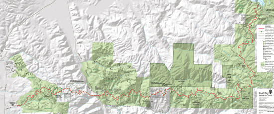
Picture 1: Map of Ohlone Wilderness TrailWe booked 24 spots each at
- Stewart’s Camp for Friday night (6.7 miles from Del Valle Reservoir) for Friday night
- Star’s Rest in Sunol’s Backpack Camp (9.7 miles from Stewart’s Camp) for Saturday night
- Eagle Spring Backpack Camp (8.2 miles from Star’s Rest) for Sunday night
Monday we will hike the remaining 4 miles over Mission Peak and do some more geocaching along the Horse Heaven Trail down to the trail head at Stanford Ave. After that we can have a big celebration meal somewhere in Fremont.
Please reply to this message if you would like to participate. You don’t need to have children to come along – just be family friendly and have patience with kids who are slower or want to take some extra time to look for a geocache. I will maintain a list of participants in this post. To cover the cost for camp sites and permits we ask $20 from adults, $10 for youth twelve and older and $0 for children under twelve.
We will provide four Garmin Rino (GPS + Walkie Talkie) that will allow several sub-groups to hike at their own speed and still stay in contact with each other. That way everyone can see on their display where the other groups are and people can talk to each other. The units will have all geocaches along the route pre-loaded so the kids can have some extra fun with geocaching along the trail.
Best Regards,
Manfred & Michelle
Participants:
Manfred – adult (paid $20)
Michelle – adult (paid $20)
Cassandra – youth (paid $10)
Elisabeth – youth (paid $10)
Hannah – child (paid $0)
Natalie – child (paid $0)
Jane – adult (paid $20)
James – adult
Becky – adult
Olivia – child
Al – childJun 9, 2013 at 9:07 pm #1995155If you are new to BPL and don't have a membership that allows you to post on here, you can just PM me. Just click on my name on the left and send me a personal message.
Best Regards,
Manfred
Jun 20, 2013 at 7:55 pm #1998565Please tentatively sign up me, my wife Becky, and our two kids, Olivia and Al. Will need to double check the work schedule as the time gets closer.
Thanks,
JamesJun 20, 2013 at 11:21 pm #1998619if the Ohlone is anything like mt diablo (which it is..), it will have some ticks. this is not a huge deal, but one might be advised to be aware of them.
the trails are very open (being dirt roads the most part) and nice.cheers,
v.Jun 20, 2013 at 11:48 pm #1998624Ohlone is a little like Mount Diablo in its climate (and therefore its flora and fauna) but the similarity stops there.
Ohlone is SO much more removed and remote. I see bald eagles every day, looking over my bowl of Cheerios in Kenai Alaska, but in the Bay Area, it is dang cool to see a bald eagle fly by. Waterfalls. Being miles from anyone. Hours, potentially days between seeing anyone else. It really is an amazing resource so close to such urbanized areas.
I was working in a backpacking store in the early 1980's, talking to many of the people who were instrumental in establishing the trail and I know a lot of people who took some of the very first (legal) trips through there. (I also knew people who did commando trips in that area before all the deals were hammered out with the Water District).
I've done it myself, much more recently and referred uber-outdoorsy Californians, Slovakian Forest Rangers, and others to it and no one has been disappointed.
Aug 14, 2013 at 4:06 pm #2015315I talked this week two times with the East Bay Regional Park District. There seems to be a problem with the water supply at Eagle Springs Camp. At this point it is unclear whether the spring is dry or the valve is blocked.
I went ahead and booked camps for Skyline-to-the-Sea for the same dates. The itinerary would look as follows
Friday: Castle Rock Trail Camp (2.3 miles from parking)
Saturday: Waterman Gap Trail Camp (7.6 miles from Castle Rock Trail Camp
Sunday: Jay Camp (8.4 miles from Waterman Gap Trail Camp)
Monday: Hike to Waddell Beach (either 8.9 miles via Mt. Mc Abee or 12.3 miles via Golden Cascade, Silver Fall and Berry Fall)People can hike all the way from the Skyline (Castle Rock) to the Sea (Waddell Beach) or decide to join us Saturday evening at Waterman Gap or even Sunday evening at Big Basin (Jay).
I was only able to reserve 12 spots for Skyline-to-the-Sea. As we are right now at 11 people that should be no problem. Can everyone please let me know your thoughts before I cancel the camps for Ohlone.
Thanks,
Manfred
Aug 26, 2013 at 8:59 pm #2018888Today I talked again with the East Bay Regional Park District and canceled our reservation for the Ohlone Wilderness Trail due to lack of water.
However we have backup plans and we will now hike the Skyline-to-the-Sea trail instead. Please PM me if you would like to reserve a spot.
Best Regards,
Manfred
-
AuthorPosts
- You must be logged in to reply to this topic.
Forum Posting
A Membership is required to post in the forums. Login or become a member to post in the member forums!
Our Community Posts are Moderated
Backpacking Light community posts are moderated and here to foster helpful and positive discussions about lightweight backpacking. Please be mindful of our values and boundaries and review our Community Guidelines prior to posting.
Get the Newsletter
Gear Research & Discovery Tools
- Browse our curated Gear Shop
- See the latest Gear Deals and Sales
- Our Recommendations
- Search for Gear on Sale with the Gear Finder
- Used Gear Swap
- Member Gear Reviews and BPL Gear Review Articles
- Browse by Gear Type or Brand.
