Topic
Hiking in Tokyo? [pics]
Forum Posting
A Membership is required to post in the forums. Login or become a member to post in the member forums!
Home › Forums › Campfire › Photo Gallery › Hiking in Tokyo? [pics]
- This topic is empty.
-
AuthorPosts
-
Apr 16, 2007 at 4:25 am #1222830
This are a few pics from a day hike last Sunday. A shakeout for my new GraniteGear Nimbus Meridian, which I am taking on an alpine mountaineering trip in May.
The hike is about 6 hours in duration, between two approximately 800m high hills in Tokyo; Takao-san and Jimba-san; about 2 hours from down-town.If anyone is actually going to Japan, I can email details of this convenient Tokyo hike which is in a very rural area. Or, details are in the lonely planet guide, Hiking in Japan.


 Apr 21, 2007 at 4:33 am #1386826
Hi
I have both LP books on Japan and keen to get back, it's been years. If you ever want to share any type of information about Japan I'd be glad to have it. Blogs, walks/hikes, sites etc.
[email protected]Cheers
Apr 21, 2007 at 5:34 am #1386828Hi Brett
Is that Takao-san?
It's a pity that the LP guide is the only real guide book available on Japan because there were serious flaws in nearly every walk I did out of it over a period of 5 years – well, in the Kanto section anyway. As an example, at the end of the Takao-san to Jimba-san walk you are directed down a narrow, busy and dangerous road – I kept having to climb over the guard-rails, above a fairly steep slope, so I wouldn't get hit by cars and trucks. I'd been walking with a lot of Japanese who I suddenly noticed had disappeared – they, following their far more sensible Japanese guidebooks, had turned off before Jimba-san on to a quiet footpath that runs down a valley to the bus stop that LP was trying to get you to. This path is actually marked on LP's map but not recommended. On several occasions before going on big walks I checked LP's route descriptions with a Japanese friend who is a guide and owns an mountaineering shop and got one of those "who-the-hell-wrote-that?" kind of looks. But the highpoint was the description of Kitadake-san which seemed, seriously, to have been written by someone who had never been on the mountain. I don't know how good your Japanese is, but if at all possible do what I did and get one of the Japanese guide books. Because they're so pictorial, it's usually easy to work them out even if you're not au fait with kanji.
Apr 21, 2007 at 8:38 am #1386842Damian, yes it is Takao-san. I edited my post to mention that. In fact, I took that "quiet footpath that runs down a valley to the bus stop" you mentioned because it time was running out and it was faster to the bus stop. We two hikers were the only ones on the trail at that location.
You are right about getting local information before hiking. I use at least two sources.. LP tells me which hikes are popular, then I buy a Japanese magazine or book on the area, and do some research on the web. A friend who speaks Japanese helps me of course.
The LP book has been great at identifying classic hikes; and I do recommend it as the best English starting point.
PM me if you want to talk further about past/future travels in Japan?Apr 21, 2007 at 11:02 am #1386861By far the best series of guidebooks for hiking in Japan are those by the publisher Shobunsha, their "Dokodemo Outdoor" series. The maps are outstanding (coupled with some of the best printing technology in the world) as well as the elevation information. They are updated every year, with very detailed information on trail times, water sources, mountain huts and campsites, dangers, alternative routes, and things to keep an eye out for. For a great starting book try the "Kanto no Yama Aruki 100 Sen", which has a very good representation of the best walks in the Kanto area. I highly recommend these books and after using them, even though they are in Japanese, you'll find yourself never using the LP books again, except for general pointers.
Apr 21, 2007 at 10:42 pm #1386912I will look for those at kinokunia. Have you found any map series with latitude/longitude lines drawn on the map? GPS is not widely used here evidently.
Apr 22, 2007 at 4:03 am #1386920My Japanese maps and guide books are in storage in Yamanashi so I can't check the publishers etc. In any case, as you say Kinokuniya should have a good range of maps and guides. Some of the maps have the names of the main peaks in both kanji and Romanji which is useful. There was also a series called "Bird-eye view" which were useful and the various guides to the Hyakumeizan ("100 Famous Mountains") had lots of useful info. One thing to be wary of is the annual guide (called "Alps 200x" I think)in an A4 magazine format produced by a company which owns the huts around Kitadake, the private road to Hirogawara (at the base of Kitadake) and the buses which are the only vehicles allowed on that road: they managed to not mention that there was a public road to Hirogawara, even when my wife rang them to check. So I caught a train and bus which took the best part of a day whereas my father in law could have driven me there in an hour.
For nearly all of the time I was in Japan I was the only person posting from there at TLB, although Areality had also spent quite a lot of time there (in fact, unbeknownst to either of us we were on Kitadake at the same time 2 years ago). It's great that you and Miguel are around. Perhaps we should be posting trip descriptions to build up a database of accurate info? I had wanted to write my own guidebook but neither my career nor my young family are conducive to that …
Apr 22, 2007 at 4:48 am #1386921Brett,
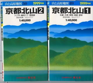
I did a little hiking north of Kyoto a few years ago. These Maps were recommended to me. They are nice but my 1999 versions had no Longitude/Latitude lines. I am sure you have seen these.

This site has GPS printed on several things they sell:
The Book Store where I got my Maps had others but I don't remember if they had L/L lines on them.
There is a bit of Geo Chaching (not sure that is spelled correct) going on in Japan.
Apr 22, 2007 at 6:00 am #1386924I have the 3D maps: my kids use them as a flying game because you can "fly" over the terrain at your choice of speed, inlcuding mach 1.5. Not sure why that's an option for hikers but it does look cool.
Apr 22, 2007 at 7:06 am #1386925Turns out my map series is Shobunsha. Thanks for all the tips, guys.. Bill, I hope I can finance a hiking trip to Kyoto, it must be really beautiful there. I was surprised you had also visited Japan; on Active Duty I suppose?
Here's the program I'm using to help plan my next trip. Input age, stride, weight, speed, etc., and then draw your course. It tells you how long it will take, and how many snacks it will take to fuel your caloric needs.
For example, the default triangle picture at bottom right if you open the link are rice balls, good for an hour of hiking, or about 160 calories. Other choices are ice cream cones, pankakes, even beers(as in the picture)! Some items are easier to pack than others.. Try it, you can hack through the buttons without knowing the kanji.
http://www.mapion.co.jp/c/f?uc=1&nl=36/14/5.085&el=137/38/4.681&grp=route&scl=70000
As an example, this course would require about 1 beer.. but I had the wrong body weight inputed..
 Apr 22, 2007 at 7:35 am #1386931
Re:
"Have you seen this interactive map site?"
Those are the official Japanese survey maps which are what I used a lot of the time. But I didn't know that they were available on-line. The commercial companies use this data and add the extras like where to view flowers etc.
D.W.
-
AuthorPosts


- You must be logged in to reply to this topic.
Forum Posting
A Membership is required to post in the forums. Login or become a member to post in the member forums!
Our Community Posts are Moderated
Backpacking Light community posts are moderated and here to foster helpful and positive discussions about lightweight backpacking. Please be mindful of our values and boundaries and review our Community Guidelines prior to posting.
Get the Newsletter
Gear Research & Discovery Tools
- Browse our curated Gear Shop
- See the latest Gear Deals and Sales
- Our Recommendations
- Search for Gear on Sale with the Gear Finder
- Used Gear Swap
- Member Gear Reviews and BPL Gear Review Articles
- Browse by Gear Type or Brand.
