Topic
Backcountry Beach Camping in Channel Islands National Park
Forum Posting
A Membership is required to post in the forums. Login or become a member to post in the member forums!
Home › Forums › Campfire › Member Trip Reports › Backcountry Beach Camping in Channel Islands National Park
- This topic is empty.
-
AuthorPosts
-
Oct 19, 2012 at 4:51 pm #1295275
I'm really fortunate to live where I do… If I walk out my front door and start heading south, I can walk to the beach in a few minutes. If instead I turn to the north, I can walk back into my local ~2 million acre National Forest (just shy of half of which is Federally designated wilderness). Needless to say, I spend a lot of free time at the beach and a lot of my hiking time in Los Padres NF.
But there's a whole 'nother grouping of Federally-owned public land nearby that I don't get to visit as often and that largely passes under the radar of most backpackers and hikers. Just 20 miles or so offshore from me sits a collection of five islands (mostly) owned by the National Park Service. I'd of course be talking about Channel Islands National Park: one of the least visited National Parks in the entire park system despite its close proximity to the Southern CA megalopolis.

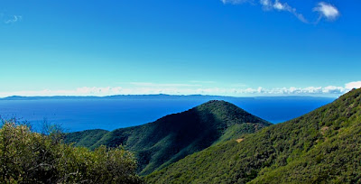
(Santa Cruz Island, which is the largest of the islands that comprise the Park sits on the horizon just offshore, as viewed from a ridgeline in Los Padres NF.)The islands themselves range in size from as little as roughly one square mile (Santa Barbara Island) to just shy of 100 square miles (Santa Cruz Island). Each of the islands offers opportunities for camping and hiking; most of which is limited to staying in a designated walk-in campground and simple day hikes on a handful of established trails and/or old ranch roads. A couple of the larger islands do however, have some opportunities for backcountry camping. On Santa Cruz Island, hikers can get dropped off at one end of the Park Service-owned portion of the island, hike to the backcountry "Del Norte" camp for the night and then hike over to the main walk-in campground the next day. It's a scenic 16-mile or so one-way hike and it's fun to do once or twice but that's it at the moment for the largest of the islands. The other option… the less visited and more logistically challenging but arguably more rewarding option is to apply for a permit to go backcountry beach camping on 83-square mile Santa Rosa Island.
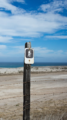
Santa Rosa Island is considered one of the outer islands of the chain. It sits both farther offshore and a bit farther up the coast toward Point Conception, a prominent bend in the coast of CA where ocean currents meet and the shoreline goes from facing generally due west to due south instead. The outer islands are harder to get to (fewer, seasonally limited boat trips offered) and are exposed to a lot more weather. High seas batter most sides of the island and strong winds tear across the ridges, valleys and beaches often blowing in excess of 30 mph. Visiting remote areas of the island is further confounded by various seasonal closures for marine mammal pupping seasons and nesting seabirds.

(You don't want to mess with these guys! Elephant seals, which can get up to 14' long and 4,000 lbs, are amongst the marine mammals that occupy many of the beaches around SRI most of the year, rendering the beaches off limits.)If you can find a narrow window when the closures are lifted, the concessionaire boat is running and the weather cooperates, you can gain permission to camp on some of the beaches around the island.
Here's a few photos with captions from our trip:

CA Sea Lions warming up on the bell buoy outside the harbor entrance.
We travelled around the backside of Santa Cruz Island to say in the lee of the island and get out of the wind and swell for a bit. Not long after taking this photo, we left the sheltered backside of the island behind and entered the white capping, churning and rolling channel between Santa Cruz and Santa Rosa Islands.
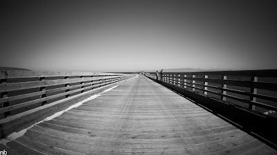
Having survived the lumpy channel crossing, we arrived at the landing pier on SRI.
And promptly got on with our walk.
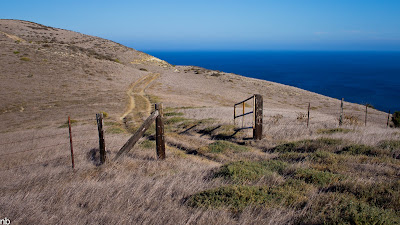
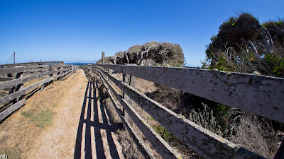
Up until recently, the island was a privately-owned and operated cattle ranch. Miles of fencing can still be found all across the island along numerous historic barns, corrals and other structures.
Looking back across the channel toward Santa Cruz Island.
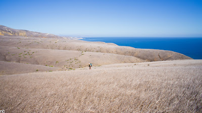
The old ranch roads comprise most of the trails around the island these days although pretty much the entire island is open for cross country hiking.
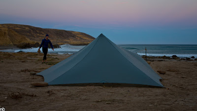
Battening down the hatches for the night. The wind is unrelenting. 40+mph gusts blasted us all day and into the night. Even being tucked up near the toe of the coastal bluff wasn't enough to shelter us from the wind. Gusts would bend over and around the headlands and down the canyons, often blasting us from two different directions at the same time. It's the only time I've ever heard the guylines on my Trailstar start to whistle!
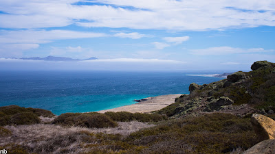
Sunrise on our own private beach for the next few days.
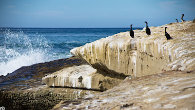
The Channel Islands are called by some the Galapagos of North America. The islands are home to numerous species of flora and fauna found nowhere else as well as abundant marine life and sea birds. Here a few pelagic cormorants and a brown pelican (in the background) take a breather in between fishing ventures.
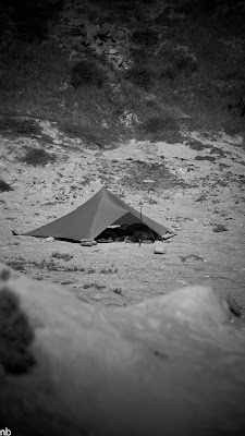
Another view of camp. With the strong multi-directional winds, the other shelter we had with us didn't prove to be up to the challenge so all three of us had to crowd under the Trailstar. By offsetting the center pole to one side, it was doable if a bit cozy, but it got all three of us out of the wind and helped to keep us away from the skin exfoliating blasts of sand that battered the side of the shelter all night.
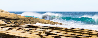
The ocean was downright beautiful at times when the winds would calm a little. Other times it looked torn up and angry.
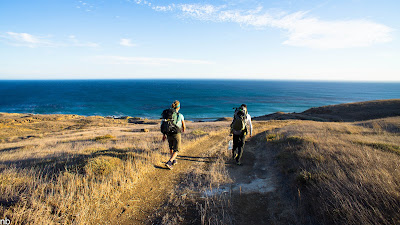
We spent a bit of time hiking up and down the coast exploring other small coves and beaches.

Fresh water on the island is tricky… there's a few reliable improved sources near the walk-in campground and one developed spring. Depending upon your location and the season, it's possible to find other "wild" sources of water around the island. We lucked out and found a freshwater seep in a cliff near camp that we could draw from… at a pace of about a liter every five minutes. Still, it saved us a five mile round trip hike to the next nearest reliable water source we could find.
No fires allowed on the island, so meals were cooked with the Tri-ti caldera and alcohol stove. After building a small wind break, the stove worked great. Without the break, it became an exercise in keeping the various parts of the kitchen from blowing away. As it is, I lost a stuff sack and almost lost a shoe to a couple of strong gusts.

Waking up to another golden morning.
On our way back to the pier, we visited some other off trail beaches and coves. This beach was perfect for a swim and lunch. It didn't seem like a good place to camp however as the high tides came up to the cliff face.
After a bit of beach hiking, we turned up a canyon, managed to find a little trickle of water to filter and then began a cross-country climb back toward the interior of the island where we would pick up another of the old ranch roads to lead us back to the landing pier area.
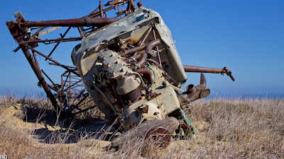
Along the way, we stopped to check out an old plane wreck site I had been told about.
Another relic of the island's ranching history weathering away.
The hills turn gold as the sun starts to slip low in the sky.
For our last night, we opted to stay in the main walk-in campground. Each of the 15 sites has its own windbreak shelter and table. The campground also has potable water, showers and the nicest, cleanest campground bathrooms I've ever seen anywhere!
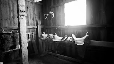
We spent our last afternoon poking around the campground, hanging out at the beach and exploring some of the old ranch buildings around the landing cove.
Hikers and campers are treated just like the cattle that used to roam the island… they send you right through the cattle chute and onto the pier, ready to load you up and send you off.
I'd give the trip a gold star!
Our last walk down the pier, awaiting our ride home.Oct 19, 2012 at 5:02 pm #1922988I've only dayhiked there (Anacapa and Santa Cruz) but it's a wonderful place! Especially in late March when everything is blooming, especially the coreopsis and ceanothus. I enjoyed your post!
Oct 20, 2012 at 9:40 am #1923140Loved seeing your photos and reading your account of camping on the islands. I have enjoyed short hikes on San Miguel, Santa Barbara and Santa Rosa because for the past three years I have gone with a group of painters (led by David Gallup) aboard an 85 foot dive boat which anchors off the islands while we hike, scuba, snorkel, kayak and paint the islands.
We've anchored off of Anacapa and Santa Cruz and have done the kayaking, painting and snorkeling thing but we haven't been able to land and hike. (Swimming alongside great groups of sea lions is REALLY a great experience.)
Next year we'll spend the whole trip off of Santa Cruz and spend some time on land as well so I'm looking forward to some hikes, there too.Thanks for sharing your experiences!!
Oct 21, 2012 at 4:43 am #1923325Nice job Nick (or whoever you are now). Lots of great pictures there. I really liked the cormorants, but there were so many others. You and few others on this site (Jake, Dondo, Gordon) have inspired me to stop taking pictures and to start thinking more seriously about photography. As I drowned my point and shoot camera last week, now seems like a great time to upgrade.
Oct 21, 2012 at 6:25 pm #1923519Thanks for the comments everyone. This was a fun trip… something a little different from the norm.
There's a lot of hassles to put up with to pull off this trip, but it was worth it. It was great to get back out to the island after quite a few years away.
Ike, when you're ready to talk about a new camera, let me know and I'll try to give you some thoughts. I'm by no means an expert or the most qualified person on the forum to talk all things camera, but I'd be more than happy to share my $0.02 with you.
Cheers,
Nick
Oct 21, 2012 at 6:38 pm #1923523Wow!
Where did you depart by boat from the mainland?Oct 21, 2012 at 6:42 pm #1923527The company that has the island transport concession (Island Packers) leaves from Ventura, CA.
-
AuthorPosts


- You must be logged in to reply to this topic.
Forum Posting
A Membership is required to post in the forums. Login or become a member to post in the member forums!
Our Community Posts are Moderated
Backpacking Light community posts are moderated and here to foster helpful and positive discussions about lightweight backpacking. Please be mindful of our values and boundaries and review our Community Guidelines prior to posting.
Get the Newsletter
Gear Research & Discovery Tools
- Browse our curated Gear Shop
- See the latest Gear Deals and Sales
- Our Recommendations
- Search for Gear on Sale with the Gear Finder
- Used Gear Swap
- Member Gear Reviews and BPL Gear Review Articles
- Browse by Gear Type or Brand.
