Topic
7 Days Solo Wind River Range Cook Lakes – Titcomb
Forum Posting
A Membership is required to post in the forums. Login or become a member to post in the member forums!
Home › Forums › Campfire › Member Trip Reports › 7 Days Solo Wind River Range Cook Lakes – Titcomb
- This topic is empty.
-
AuthorPosts
-
Sep 9, 2012 at 2:54 pm #1293898
This was just my second major backpacking trip. I had done several overnights here in Florida, and then did a 5 day trip to Rito Alto Lake in the Sangre De Christo Mountains in CO last year. This trip took place August 25 – 31st.
Day 1: Elkhart Park to Somewhere on the Monument Creek Cut-off. I started off around 9:00 AM. I was quickly joined by two really nice guys from Wisconsin (who I met earlier in the parking lot). They were hiking back to Hobbs Lake to help a 70 year old guy from their party carry his stuff out. They walked and talked for at least the first 3 miles. At some point they stopped to talk to another group and I kept going. Just then I saw the 70 year old they were talking about. I knew it was him right away by the way they described him- a mane of near shoulder length white hair coming down from his hat and he was carrying an off white canvas bag. He seemed to be handling the weight of his pack pretty well. I said “pleased to meet you, I’ve heard all about you on the way up. Your friends are just couple hundred yards behind.”. Just then the guys from WI spotted us and started yelling. They thanked me and wished me a great trip. Nice guys and a great way to start a trip.
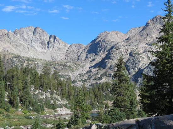
I continued on in silence for quite a while. The trail is pretty easy and uneventful to Photographers Point. Once I got there the peaks were hard to see due to smoke. Still of all the pictures I’ve seen, none of them did the view justice. You have to be there.
I continued on to the Pole Creek trail and wanted to try the Monument Creek Cut-off. About a mile after Mary’s Lake I stumbled into it. I was running low on water and feeling a bit fatigued at this point. I stopped at a stream near the “Y-shaped Pond” to get water. For some reason my gravity filter was running real slow. I took me more than an hour to get what I needed. By this time it was after 5 PM.
I had already made my first mistake of the trip, actually happened weeks before- when I decided I could make it to my intended campsite at upper Cook Lake the first day- 11.5 miles. Coming from Florida the altitude has an undeniable effect.- as do the elevation gains. I should have learned from my CO trip the year before, but this trail had much less elevation gain- I CAN do it! Well the Monument Creek Cut-off had more ups and downs than I anticipated from the topo maps and I was really dragging. Before long it was 7:00 PM, I was low on water again and needed to make camp before dark. I stopped at a flat area near a pond. I was beat. I set up camp, got some water going, and it was dark. I jumped in my bag without eating anything (altitude killed my appetite) . I was thirsty, sore, and tired. I over did it for the first day and new it, yet I was only about 1.5 miles from my goal. I was very frustrated. In my tent I tossed and turned and wondered WTH am I doing?
Day 2: The Cut-Off to Upper Cook Lake. I woke up around 6:30 AM. It seemed a bit brisk so I put on my insulated coat, gloves and hat. I stepped out to frost.. On the ground, my tent, my backpack. Checked my Bruton instrument- 27* ! My thoughts quickly turned to my water filter. I checked it and water was still trickling through it, didn’t seem frozen at all. Better than that I had nearly three liters of clean water.
While checking on my water I spooked a large mammal out of the woods. I saw it run into the clearing about 40ft from my tent- a female moose. I thought it would keep running but it stopped, and stared at me. I had my bear spray handy just in case. I moved toward my pack slowly and got out my camera. I was able to take some shots but the light was still slow. The moose would not leave. It would take a few steps and then stop and stare at me. I was ready for it to go at this point. I tried kneeling, moving behind a tree, banging my trekking poles together, nothing worked… Moose just stared.. It moved to my right and I thought this time it was leaving- until it turned and took a few slow lumbering steps toward me. I moved back and to the left and was standing partially behind a tree. I talked to it, but it just stared.. Finally after 20 minutes it seemed to lose interest, and lumbered partially down a hill. I got back to clearing camp and packing up- always keeping my eye on the moose. Eventually it strolled out of site.

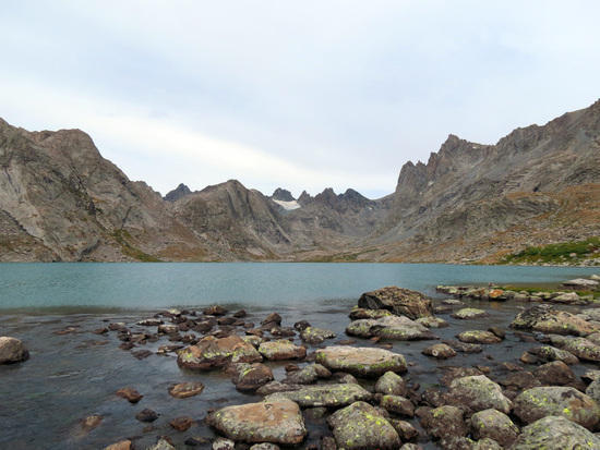
I gave my tent a chance to dry out, forced myself to eat a nutrigrain bar, and was on my way toward Cook Lakes. I was fatigued and sore, but anxious to get to Cook. It took me two hours to get to my campsite. What a great campsite it was- flat short grass, a giant flat rock about 4 ft high, perfect bear bagging tree, easy water access.. I set up camp, relaxed, ate and was lazy. I walked around the lake a bit, taking in the scenery and catching a few brook trout.
Day 3: Cook Lakes. I woke up feeling pretty good. I planned to day hike towards Wall Lake to see how the pass and off trail route to Island Lake looked. I fished my way around Upper Cook Lake, catching several small brook trout (all caught fishing deep), and got a look at the area, but did not feel like going all the way to Wall Lake.

On the way back I ran into a backpacker at the South end of the lake. Steve had been to this spot many years before and was bringing a friend to hike and fish. He said his friend was very slow. He walked with me for a half mile or so looking for a good campsite. He was in communication with his friend via small radio and his friend found several nice spots so Steve bid me farewell. I went back to camp, showered, ate, and fished some more. I saw heavy rain clouds near the Wall Lake area . It looked like it was raining pretty good. I got a few sprinkles but nothing more.
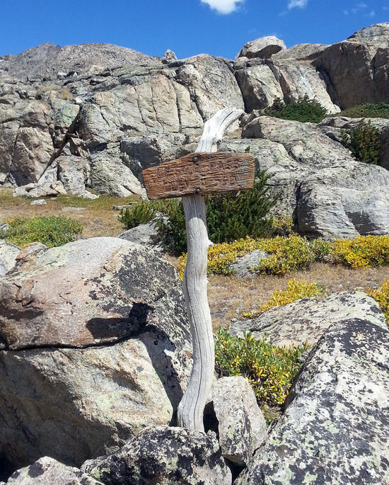
Day 4: Cook Lakes to Island Lake. I planned to take the classic Wall Lake to Island Lake route but as I was about to leave I noticed clouds gathering near Wall Lake and remembered the heavy rain the day before. I looked at my map and decided I would take the Highline trail over Lester Pass to the Indian Pass trail. It couldn’t be much worse could it? Mistake number two! About halfway up the Highline trail I notice the skies are clear all around.. I should have taken the Wall Lake route! The hike up to Tommy Lake felt strenuous but I was still optimistic. I took a short break to eat some lunch and saw a hiker go by. As I approached Tommy Lake I noticed it was Steve. He and his friend were day-hiking to Tommy Lake to fish. We talked for quite while. He planned to head out on a Sierra club trip the day after this trip ended! We talked about his trips to the Beartooths and both our experiences in the Sangres. I knew I had a tough hike over the Pass so I moved on with renewed energy.
Lester Pass was tough. There are few switchbacks coming from the East and it is steep. I was really cursing my decision to take this route. At one point I only went 20ft or so between stops to catch my breath and let the burn escape from my legs. After some of the toughest hiking I’d experienced I made it to the top of the pass. I walked to the west side and put down my pack. The view was amazing. It looked like a giant painting. I could see the Seneca Lakes and some of the peaks and glaciers of Titcomb. I admired the beauty for a while, but vowed this would be my last trip up Lester Pass from the east.


As I made my way down I thought the west side seemed like it would be an easier climb. From there the hiking was easy until I hit the small pass just to the N of Little Seneca Lake. Steep, rocky, and the trail is not in the best of shape. I had to stop 4 or 5 times to let my body catch up before reaching the top. I was getting pretty tired at this point and grumbled as I made my way up the last hill before Island Lake. I made my way to the top of the hill and stopped to admire the view of Island Lake.
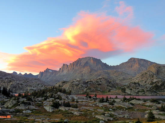
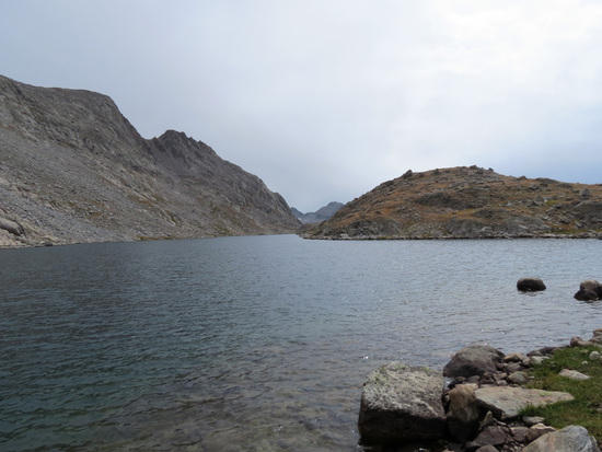
I planned to camp somewhere towards the N end of the lake. As tired as I was getting I should have settled for the south ¼ of the lake, but I proceeded to take the trail that runs along the shoreline towards the North. Mistake #3. The trail has plenty of ups and downs and eventually gets narrow with a steep drop on the right as you head North. There were several large downed trees obstructing this unmaintained trail. The trail continued to get worse and I decided to head back South. What’s another ½ mile? At this point I was very tired and my legs were cramping a bit. I found a flat spot above a pond just off Island Lake and set up camp. Eventually I noticed someone camped above me and lots of traffic below . I knew I’d be moving tomorrow. I enjoyed some water, jerky, dried fruit and admired the sunset.
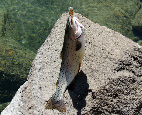
Day 5: Island Lake. Wow.. I woke up stiff, sore, and with zero energy. I boiled some water and had Mountain House Scrambled Eggs and Bacon. Not bad.. I knew I was day hiking to Titcomb the next day so I decided to take it easy and eat as much as I could to recover and have some energy for the next day. I moved camp to a nearby area with a little more privacy. I did walk all the way out to the last island, rock hoping between islands. The lake was down about 2 feet allowing me to get out there. I caught a nice cutt fishing from the last island. Other than that I was pretty lazy. I got everything ready for the hike to Titcomb, ate and went to bed.


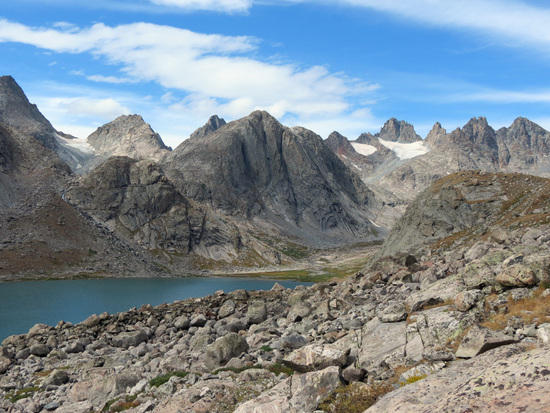
Day 6: Titcomb Basin. I woke up feeling renewed. I was excited! But the sky looked threatening. It sprinkled a bit and the wind was blowing cold. I thought, “If this day is a washout I’m going to be really p#ssed.” Around 9:00 AM there was a break in the clouds. That’s all I needed. I grabbed my lumbar pack, some water, my fishing rod, and I was off. The hike up towards the basin was surprisingly easy. Above the first lake N of Island I ran into a group that was leaving the Indian Basin area. We shared stories of our routes and discussed our campsites. They gave me lots of advice about campsites for next time and which lakes to fish. Everyone in the Winds was amazingly helpful, and I tried to be as much as I could with my limited experience.
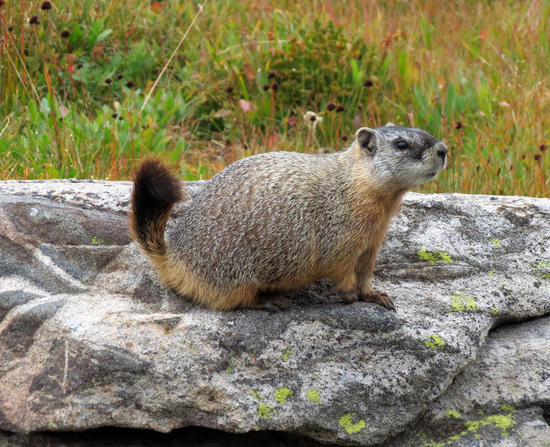
I fished all of the lakes on the way up to the basin and caught absolutely nothing. I saw no signs of fish, and had no strikes. I noticed some weather moving toward the basin as I approached the lower Titcomb Lake. I found a sheltered space between a couple rocks and hung there while it rained. It looked like it was really coming down in the upper part of the basin, only light rain around me. Eventually it slowed to light drizzle. It had become cold and windy. I put on my rain jacket and continued on. Once I reached the first big lake the beauty of the basin began to unfold. Unfortunately the grey skies did not help my pictures. The pictures just don’t do it justice. I continued up to the second lake and rock hoped out into the outlet stream for some pictures of the upper part of the basin.I wanted to fish Mistake Lake and I noticed a trail heading that direction. As I made the steep hike up the trail disappeared. I could see a decent zig zag route up to the top and quickly reached the lake. It was very quiet up there, and out of the wind. I fished for about an hour, trying all depths and retrieves – for absolutely nothing. I did hear a couple fish jump and saw the ripples from the jump. Getting down from Mistake Lake seemed more difficult than going up. The skies were clearing to the north but looked increasingly dark to the south. I decided to head back towards camp and picked up the pace. I met a friendly marmot by the lower lake. I fished a few outlets on the way out, again no sign of any fish.
As I left the basin behind I came to the first large lake to the North of Island and noticed the trail to Island Lake falls so I took it to get a close up look at the falls. After getting a close up look at the falls I walked around the lake back toward camp.
I knew it was my last day at Island Lake.. I had to start heading back, and I needed to allow myself 2 days to do it. It was easily the best day of the trip. The basin was incredible and I think I was finally fully acclimated after 6 days. I showered (using a pocket shower) ate and got my gear ready to pull out tomorrow.
Day 7. Island Lake to Sweeny Lakes (or was it?). It always takes longer to pack up than I think it should. I hit the trail at 9:00 AM. Lots of ups and downs on the way to Seneca Lake, but I felt great. After Seneca Lake There was a long and fairly steep downhill section. I passed several people heading up and they were all hating it. I was happy to be heading down. There were several climbs to come for me, but nothing like that.
Somewhere after the climb out of Hobbs lake I heard thunder. It began to sprinkle, but I couldn’t see the dark stuff – yet. Eventually I rounded a corner and could see it was about to rain, and rain hard. I began looking for a place to bail, but could find no rocks or crevices to hide in. I got under some trees behind a large rock (out of the wind) and it began to rain. I put on the backpack cover and rain jacket. I heard thunder 3 more times, but it wasn’t close. I stayed hunkered down, and mostly dry, for about an hour. Once the rain slowed I continued on. I came to a spot that should be called Photographers Point II. You can see all of the peaks, and what I saw wasn’t pretty- clouds below the peaks and more rain coming. It was then that the idea of hiking all the way out came to mind. I could set-up camp in the rain and possibly spend the rest of the day / night in the tent, or I could hike out and have a hot shower, Wind River Pizza, and a dry, warm bed. What would you do? It was 3:00 PM and I knew I had 5 – 6 miles of easy, gentle downhill hiking to go. I turned it into high gear. I passed the Sweeney Lake trail without slowing down.
When I came to Photographers Point the view was ominous and I thought about getting a photo, but didn’t want to fish the camera out of my backpack in the rain. I kept going.. It would continue to drizzle the rest of the way out. I stopped twice to take a break and still made it out at exactly 5:00 PM. As I was getting my stuff into the rental car it began to rain harder- and I knew I made the right decision. I got a room at the Hampton in Pinedale ( great hotel) showered and got a stuff crust pizza from Wind River Pizza- very tasty!
Summary: I made some mistakes that probably ended up costing me 2 days of day hikes I wanted to do. I am still frustrated that I didn’t take the Wall Lake route, but it didn’t spoil my trip. I love Wyoming and the Winds. Next trip I’m going to take it easy the first day.
I saw, literally, 5 mosquitos the whole trip. I never wore repellant- at all. It was really dry (until the last day), and I had no wet stream crossings. There was no sign of bears. No scat, tracks, or sightings. No one else saw any sign. There was nothing for a bear to eat that I could see. I imagine they were where the food was. The fishing was not that good. Everyone I talked to said it was way worse than usual. They thought it was because of the abnormally hot summer. A guy at the Great Outdoor Store said the same thing before I left.
If you are coming from an area close to sea level like me, the altitude will have an effect on you. As will the uphill hiking. It’s very difficult to fully prepare for Wyoming Mountains when you live in Florida.
It’s hard to believe last week I was in the Winds.. The trip went so fast. I was just hitting my stride and it was time to head out. I miss it, and can’t wait to get back.
Sep 9, 2012 at 5:52 pm #1910691Great report and pics Dan.
I spent a week up that way late in June…we camped at Miller and Island on the way in to Indian Basin w/ a day hike to Titcomb. Lots of snow and smoke on our trip. The snow was great, but the smoke from a fire burning in the Wyoming Range to the West really put a damper on the last few days. We had ash and cinders falling on us up in Indian Basin.
Beautiful country though!
Sep 10, 2012 at 4:48 pm #1911050I didn't have time to read through all of the text yet, but there's some stunning photos in there. Beautiful landscapes. Yours is among a couple of recent posts from trips to the Winds that are driving home the point that I must get out there one of these years to have a look around.
I look forward to coming back and reading the rest of your TR later this evening.
Cheers,
NickSep 12, 2012 at 9:21 pm #1911827Enjoyed your report and photos! I had to cancel this year's trip due to a nasty bout of plantar fasciitis. It is now better (although I'll probably have to keep on doing the extra stretching for life) and I've worked up to a whole 1 1/4 miles of walking. Hopefully by next spring I'll be back in shape!
Although I grew up in Laramie, WY (7,100 ft.) and spent summers in the Colorado Rockies at 10,000 to 12,000 feet, I found that after many years living at sea level (my house is at 300', but close enough) the altitude made things really difficult. I found that it's best to plan several days to acclimatize–gaining altitude gradually and planning very short days at the beginning of the trip. I had the same symptoms as you–fatigue, lassitude, loss of appetite. Of course reactions to high altitude differ with individuals; some get seriously ill at as low as 8,000-9,000 feet while others have waltzed through the Winds with impunity. I'm OK until approaching 10,000 feet, at which the symptoms start hitting.
Sep 19, 2012 at 8:05 am #1913636I was in Wind River Range the same time as you and was camping in Titcomb basin on the night of the amzing sunset (I think it was wed 8/29) and have some similar pics of it. It was my first trip to the winds and it was truely spectacular. Thanks for sharing your trip report.
-
AuthorPosts


- You must be logged in to reply to this topic.
Forum Posting
A Membership is required to post in the forums. Login or become a member to post in the member forums!
Our Community Posts are Moderated
Backpacking Light community posts are moderated and here to foster helpful and positive discussions about lightweight backpacking. Please be mindful of our values and boundaries and review our Community Guidelines prior to posting.
Get the Newsletter
Gear Research & Discovery Tools
- Browse our curated Gear Shop
- See the latest Gear Deals and Sales
- Our Recommendations
- Search for Gear on Sale with the Gear Finder
- Used Gear Swap
- Member Gear Reviews and BPL Gear Review Articles
- Browse by Gear Type or Brand.
