Topic
Piru-Maniacs: Three Back to Back (to Back) Trips Through the Piru Creek Watershed; Ventura County Backcountry
Forum Posting
A Membership is required to post in the forums. Login or become a member to post in the member forums!
Home › Forums › Campfire › Member Trip Reports › Piru-Maniacs: Three Back to Back (to Back) Trips Through the Piru Creek Watershed; Ventura County Backcountry
- This topic is empty.
-
AuthorPosts
-
May 25, 2012 at 1:02 pm #1290331
Part I: To the Headwaters…
Finally, the swelling of my hands and the stinging on my shins (more on this later in part III) has subsided enough that I can sit here and comfortably type out this trifecta of trip reports.
An interesting series of events came together recently providing me a unique opportunity to hike three distinct sections of the Piru Creek Watershed in the Sespe Wilderness within less than a week’s time. Piru Creek runs from near the summit of Pine Mountain generally eastwards to Pyramid Lake before hanging a right hand turn and heading southerly to Lake Piru before whatever water’s left eventually joins the Santa Clara River. Much of the watershed resides within the Sespe Wilderness of the Southern Los Padres National Forest and is currently being considered by Congress for inclusion in the Nation’s designated Wild and Scenic River system. The creek runs for approximately 70 miles and all told, drains an area of approximately 500 square miles. It’s considered to be one of the larger, still mostly natural creek systems left in Southern California.
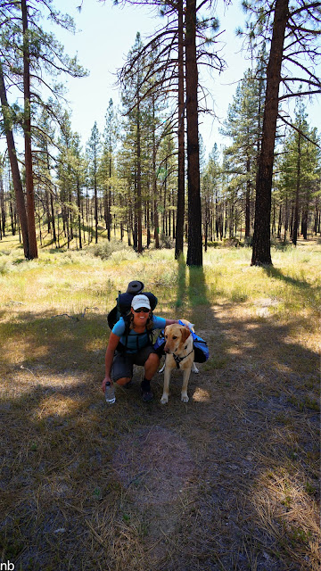
With the recent re-opening of seasonal road closures, my girlfriend and I decided it was time for an easy overnighter in the local mountains. Due to the exceptionally dry winter, our choices of hiking destinations were somewhat restricted by where we could reasonably expect to find reliable water. The hot, dry weather further limited our options as we’d have our pup along with us for the hike and overheating was a legitimate concern for a 95lb waterdog. Ultimately, a quick overnight trip to a popular camp near the headwaters of Piru Creek seemed like the perfect answer.

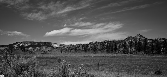
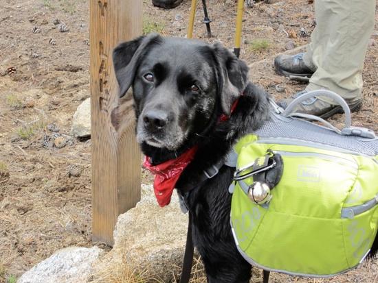
At the trailhead, ready to go.The trail follows the Piru Creek river valley gently upstream approximately 6 miles to a cedar-shaded, creekside camp. The river valley is broad and open, alternately passing through sandy flood plains and pine-spotted grasslands as it meanders along through a series of big sweeping turns. There are numerous criss-crossings of the creek, providing ample opportunities for Bixby to get a quick dip in the water for a cool off.

Downstream view.
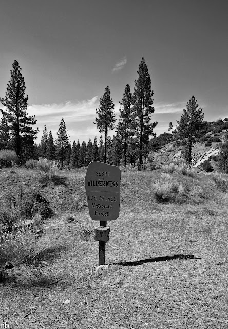
Upstream view.A couple of miles in from the trailhead, we formally entered the Sespe Wilderness boundary although the entire trail is within de facto wilderness. The trail alternates between being well worn single track in places and faint, grown over tread in others. Really though, other than the frequent detours to avoid the numerous (25+) blowdowns across the trail, it’s a simple straightforward walk that never leaves the river valley floor.

Wilderness boundary.
Water stop to cool off and get a couple of treats.
As we approached the camp in the upper reaches of the drainage, the canyon began to narrow in and take on a little steeper profile. The patchy pine clusters and grasslands were replaced with dense riparian brush and the occasional cedar or two towering above. A bit of bushwhacking was required as the well-watered chaparral began to encroach upon the tread. Right as we entered this section we came upon a 50lb bear foraging for food. Upon spotting us, he hightailed up the ridgeline and off into the depths of the woods. Given the bear’s small size, we (safely) figured it was on the verge of still being a cub and paused for a bit to see if mom was around. Not seeing any signs of other activity, we cautiously continued along upstream without any other exciting wildlife sightings.

Our only snake sighting of the trip, a lazy gopher snake hiding out by the water's edge.Upon reaching the camp, we quickly confirmed that we had the area to ourselves and promptly claimed the lower camp set amidst some creekside VW-sized boulders and tall cedars as our spot for the night. We enjoyed a lazy afternoon and evening around camp as we watched the light fade out and night take over.
Setting up camp.
Sawyer Squeeze filter in gravity mode.
Bixo keeping an eye on things.
Camp overview.
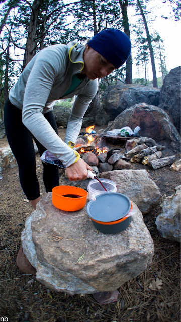
Warming by the fire while the Ti-tri heats up water for dinner.
Trailstar with Bearpaw Wilderness Designs Pentanet 2, big enough shelter for the three of us.
Dinner for the night; pesto couscous with sun dried tomato, pistachio pieces and a salmon packet.
Washing dinner down with a little vino.
A graphic representation of our camp for the night.
Studying the map as we decide whether to make a loop or an out-n-back out of the hike.
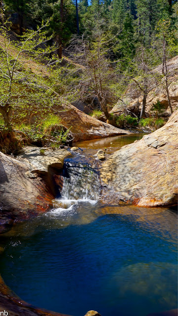
Wrapping up the night around the campfire.The next morning dawned cold and clear as we waited for the sun to creep high enough into the sky to warm up our cam nestled down in the canyon. After breaking camp, we continued over to the upper camp and beyond to a section of the creek that abruptly narrows in as it passes through a sandstone choke point. Set in the middle of this narrows are a couple of deep pools that give the campsite their name. The pools were nice and cool and filled with plenty of water for a quick dip.

Waiting for that sunlight to reach us down in the canyon bottom.
Couple of snowplants poking up through the pine duff.
Bixby presiding over camp.
Warming trend.
Cedars amidst camp.
Namesake swimming holeFrom there, it was just a matter of a simply retracing our steps back down the river valley and to our truck parked at the TH. Trip #1 was in the bag! Trip #2, an ambitious dayhike and peak bagging extravaganza loomed on the horizon for the next day…
CA Alligator lizard sunning
The walk back out
A final view on the drive out.May 25, 2012 at 1:04 pm #1881152Part II: A High Country Romp Amidst Piru’s Peaks
A week or so before the overnighter with my girlfriend, a fellow avid Los Padres hiker and loose acquaintance of mine suggested we team up for a trip sometime. Over a series of subsequent emails, we began to compare notes on our own Los Padres “to do” lists. There were a few hikes and/or destinations that, as of yet, had eluded both of us. One destination in particular, an isolated high peak (by Los Padres standards) way out in the Sespe was high on both of our lists.
It didn’t take much convincing for either of us to decide that a peak bagging, off trail scramble to Cobblestone Mountain and some of its surrounding peaks ought to be the site for our first collaboration. Next thing we knew, we had a date set for what would turn out to be one heck of a day hike!
As the Cobblestone hike immediately followed my overnight trip with my girlfriend, it was a bit of a whirlwind Sunday afternoon unpacking from one trip while simultaneously packing for another. Given the off-trail nature of the impending hike, a smaller, tough, climber’s rucksack was deemed the proper tool for the job rather than the typical UL hikers pack. It would turn out to be mostly loaded down with (not quite enough) water and (too much) camera gear. After getting about 4.5 hours of sleep, I was off at 3:30 a.m. to meet up with my partner for the loooong drive to our trailhead.
Several hours later, after a long, rough and windy 4wd Forest road, we reached the end of the road and our lonely trailhead. This was a new area of the Forest for both of us and the views enjoyed from up above 6,000’ elevation at the trailhead as the sunrise did its thing was a beautiful sight. Right there from the parking lot, in plain view were our peaks for the day. Looming off to the right, mostly by itself was the day’s principal goal: 6,699’ Cobblestone Mountain. As we slung our packs over our shoulders and headed out, I couldn’t help but feel like we were heading out into an area that sees very little use despite the irony of the unexpectedly well-maintained trailhead sign and handicap parking space at the road’s end.
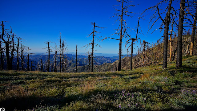
Cobblestone, front and centerThis area wasn’t always so remote and forgotten though… back in the 40s and 50s, a few official hiking and equestrian trails use to cross this landscape, including a couple of different routes up to the top of Cobblestone. By the mid-60s however, those trails had already been abandoned by the FS and left to revert back to the wild. By the 80s, the route to Cobblestone was already taking on a bit of a legend status amongst Los Padres hikers as being a brutal, pain in the a$$ bushwhack and scramble. Things haven’t improved since then… The 2006 Day Fire burned through the area and for a couple of brief years, may have opened up the country a little bit for off-trail travel. However a few healthy years of rainfall and re-growth mixed with unburned swatches of brush and numerous skeletons of trees lost in the fire have subsequently re-consumed the area.
Evidence of the Day Fire abounds. Unfortunately very few new pines are sprouting up to take the place of those lost in the fire.Our first peak for the day was a simple minor detour off the historic trail to the summit of “Sewart” Mountain (apparently the “t” in Stewart was accidentally dropped decades ago and the new name, Sewart, has stuck ever since). Short sections of tread were visible on the approach to Sewart as we quickly stepped over and around more fallen trees than I experienced on the overnight hike just the two days prior. The official summit is nestled amidst some granite boulders a 100’ or so above the trail. We stopped for a brief moment to check out the summit register (it turned out to be ruined by a combination of year’s worth of fire and rain) and pick our route along the ridgelines for the next portion of the hike.
On the way to Sewart Peak.
A nice stretch of tread atop Sewart. Cobblestone and White Mountain are dead ahead.
Panorama from atop Sewart.
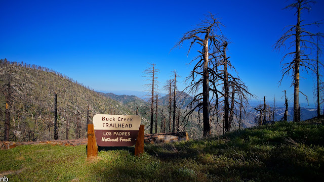
Checking out the trail register… or what's left of it.From Sewart, our route took us steadily downhill toward the top of the Buck Creek drainage. Along the upper rim of the canyon, we cached some water in the hollowed out remains of a burned out tree for the hike out. The area has a reputation for being very hot and dry (there are a surprising number of geographic features in the area with “Devil” in their name), so I packed water accordingly: 3.25 liters to take with me on the walk, 2.5 liters for the cache and another 2 liters, frozen, underneath the truck in the shade waiting for me back at the trailhead. Early in the day, the temps were cool and a refreshing steady wind blew along the ridgelines, but by the end of the day, the temps would climb easily into the low 90s and the wind would turn hot and dry. No reliable water sources are to be found in the area without dropping way down into the canyons below. Even then, reliable water is a bit of a gamble.
The view from our water cache, overlooking Buck Creek.From our cache, we continued our steady descent, climbing over fallen trees, bashing through thick chaparral, getting stabbed by yuccas and trying to dodge the dreaded Poodle Dog bush. Intermittent stops were necessary, when we could actually see out past the immediate brush, to gauge our progress and make sure we’re still headed in the right direction. A few miles in, the route bottomed out where the flank of the Sewart Mountain formation met the start of the White Mountain ridgeline. This point marked the start of our first climb of the day and set the tone for what would come to be a pattern: lose 1500’ of elevation and then gain it back, over and over for 13 miles.
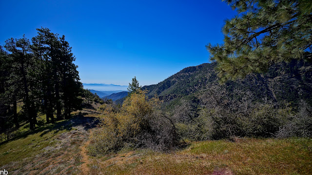
The lower ridge of White Mountain was more of the same thick bushwhacking but somewhere along the way, the brush gave way to a defined ridge covered in (still living!) mature pines and carpeted in grasses and wildflowers. It was a downright sublime setting parked on top of the ridgeline with commanding views. The ridgeline itself, in spring, could be arguably worth the walk.
Serene setting atop the White Mountain ridge.
Walking the ridgeline.It didn’t last long however, before it was time to leave the clear ridge behind and take the plunge off the south face of White Mountain down a steep and loose 45 degree slope, slipping and sliding our way through more scratchy and poky brush to a small saddle 1,000’ below us which would be our approach to Cobblestone.
The view from the saddle, looking into the headwaters of Agua Blanca Creek.
The ridge we descended from White Mountain to the saddle. Our route pretty much followed an imaginary line straight up and down over DS's head.
The saddle was dotted with these delicate, small flowering succulents.From the saddle, there was no discernible route up the 1500’ north face climb of Cobblestone Mountain. Instead, we planned to simply hike straight up the face, detouring around thick brush or rocky faces when necessary.

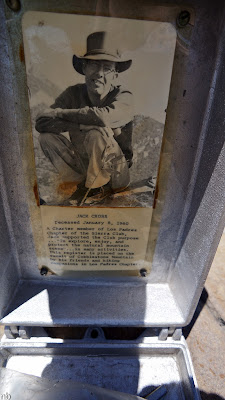
A Panoramic view of White Mountain from about halfway up Cobblestone.While steep, the climb up to Cobblestone ended up not being quite the epic challenge it looked from afar. It wasn’t long before we were making the final approach to the summit proper where a small clearing was dotted with boulders, one of which had a metal Sierra Club register box on it, like the ones found in the Sierra Nevada. This one was dedicated to early Sierra Club member John Cross.
Summit view.
Peak register exterior.
Peak register interior.
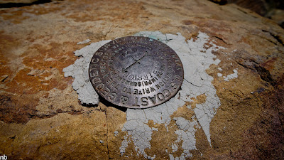
USGS Benchmark.The views from the top of Cobblestone are impressive to say the least. Santa Cruz Island was visible to the west, off in the distance past the Topatopa mountains that frame Ojai and Santa Paula. To the north, Pine Mountain and the rough location of my previous days’ hike were visible. To the south, the 5 freeway and the various peaks and mountains that make up Angeles National Forest were visible, and to the east, way off in the distance we could just barely make out the peaks of the southern Sierra. Below us, we could see some of the canyons that would feed into our next hike along the Piru that would be coming up in a few days. We spent a while on top of Cobblestone, reading through the past register entries and enjoying the views. Turns out we were the first people to reach the summit of Cobblestone in 2012. Judging by the infrequency of visitors, we might also be the last visitors for 2012!
View toward Malibu and the Santa Monica Mountains.
Reading through the registers is always fun. The highlights of this register included a multi-page "ode to cobblestone" poem and a long entry from a multi-time summiter that ended with a "I heart Cobblestone."Having spent enough time on top of the summit, we retraced our route back down to the same saddle. From here we then loosely followed our same route, back up the steep 1000’ face to White Mountain. This loose, brushy and steep climb was made that much harder by the now high afternoon sun beating down on us. It would prove to be, by far, the hardest part of the day’s hike. It was probably also responsible for later troubles to come…
Another view from the saddle before starting the climb back up to White Mountain.Having made it back to the top of the White Mountain ridgeline, we took a well-deserved rest in a shady grassy spot before continuing out along the ridgeline to the proper summit of White Mountain, another mile or so away. The ridge gently dips up and down, staying mostly within a pleasant park-like setting until the final scratchy and sun-exposed bushwhack climb to the summit. The summit was unremarkable in the most basic sense of the word, just a cramped clearing beat down by the sun and ringed by dead burnt brush. A short break here revealed the makings of trouble… We were a good 4 miles from our water cache and I was down to about ½ L of drinking water left. I run hot on even the coolest of days and this day’s heat was already taking an effect on me. Now the added stress of worrying about running out of water would compound my woes.
The pleasant walk toward the White Mountain Summit.
The view from White Mountain summit back to the start of our hike, just on the other side of the peak in the center of the frame.I let my partner know that I was having a bit of trouble with the heat and that I was almost out of water. We planned to take it real slow on the hike back and find a pace I could comfortably hold. This worked for a while until we got down to the base of Sewart Mountain before even this was on the verge of no longer being a viable strategy. I was cooked. My limited ability to think clearly at the time, led me to believe that I was dancing around the edges of heat exhaustion, a serious condition that could quickly devolve into even bigger problems. The last two mile climb back to our cache has to be the slowest, most frustrating hike of my life. I had nothing left for energy and precious little water. I’d trudge along for 15 minutes, stop, and rest, curse myself for not bringing more water or for even attempting this hike this late in the year, and then start over. I ran out of water just before making it to our cache. Totally and utterly spent. I scared myself a bit with this one, letting myself get so run down and close to real trouble.
I collapsed into a pile of hot, sweaty, tired limbs on the ground, stripped off clothes and proceeded to chug down a liter and a half of what turned out to be quite hot water without so much as a pause. I chased it with a ¼ liter more of super concentrated Gatorade which seemed to have brought me back to normalcy a bit. After a bit, we got ourselves recomposed and knocked out the last 1.5 miles back to the truck with (for me) newfound energy. All told, we had covered 13 miles of mostly off trail travel with over 6,000’ of elevation gain and the same in elevation loss. A solid day’s work, especially in the heat!
Final farewell view.Happy to be done and vacillating between some humble pie and a sense of accomplishment, we started in on the long drive back home while laying the groundwork for the final piece of this Piru trifecta which we would tackle a few days down the road.
May 25, 2012 at 1:05 pm #1881153Part III: Down the River
During the same email chain that ultimately resulted in planning the trip to Cobblestone Mountain, I threw out another idea that had been bouncing around in my head for the last couple of years. I had previously hiked another remote stretch of Piru Creek and had been impressed by some of what I'd seen. On that trip, high water made for slow progress and eventually turned me back a bit short of where I had hoped to end up. I'd been meaning to get back there and walk the whole stretch as a proper trip.
My buddy seemed intrigued on the suggestion and after pouring over some maps and doing a little internet sleuthing, we agreed to give it a try. We had a narrow window of time that fit both of our schedules, so we said, "let's go for it!" We knew the hike would be about 25 miles total with about 18 of it being off-trail. We also knew we'd be getting wet and doing a lot of bush-whacking. We thought we might be able to push through it as a day hike but would plan for an overnighter just in case. The rest would be a surprise.
For this third, and final part of the Piru-Maniacs Trip Report, I'm inclined to let the photos tell more of the story…
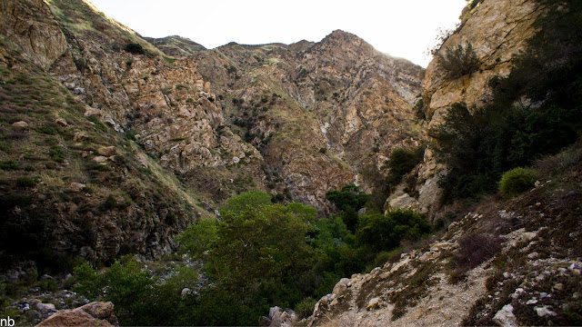
Our walk would pass through this old shut down FS car camp and down the canyon in the center of the photo. We'd pop out of the same canyon about 20 miles downstream.
Close in to the trailhead, there's ample evidence of heavy use by knuckleheads: trash, graffiti and lots of guerilla camps. However once you're more than a mile or two in, all the signs of others vanish and you're left with what amounts to one of the wilder stretches of wilderness I've encountered in Southern CA.
A faint use trail can be followed for the first mile or so…
The canyon makes numerous sweeping turns, doubling back on itself over and over. The walls typically rise up a couple of hundred feet above the creek. For most of the way, the canyon is only around 150- 200' wide. In some places, it narrows significantly as you'll see below.
HUGE(!!!) bird prints; probably a Great Blue Heron.
Once the use trail petered out, we took to following game trails. For much of the way, we were following foot prints of a very large bear. Even in the grass, we could see big, round depressions through the grass. As we came around one corner, we even caught a glimpse of one of the big guys! A big ole shaggy black bear, standing about 4.5' tall at the shoulder stood right across the creek from us! Before either of us could get out a camera, he lumbered off into the bush.
I believe the peak in the center background to be Cobblestone Mountain from our previous hike.
One of the last fire rings we'd see…
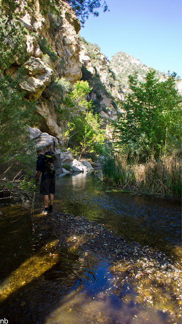
There's no easy way to get through the canyon. We'd pick our way along one bank or the other for awhile until the brush got too thick to go any farther. That was usually our cue to cross to the other side and look for greener pastures, or, like here, just drop down into the creek and walk right down the middle of it.
On one side of the creek or the other, there would often be a high, sandy bench that would allow a brief respite from bush whacking through willow thickets and blackberry brambles. The benches were still thick with brush, especially yuccas and white thorn ceanothus but it was easier to navigate when you could see more than six feet in front of you!
A wide angle fixed lens doesn't allow for the best wildlife viewing, but the small black speck in the sky was one of several condors we saw soaring overhead over the course of the trip.
Native plant, Datura, important in the local Chumash Native American culture.
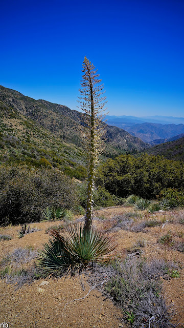
Our Lord's Candles blooming in the canyon.
A panorama showing one of the sweeping turns the canyon takes.
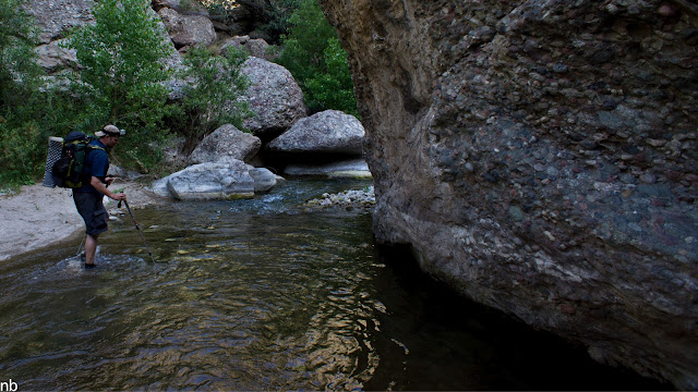
Straight down the middle was sometimes the easiest path, although slippery cobbles and deep pools made for tricky footing.
The amount and diversity of wildlife in the canyon was impressive. Besides the bears, we also numerous species of snake, turtles, frogs, crayfish, trout and an amazing, diverse array of birds, including three different species of ducks, owls, condors, a couple different species of hawks and one of the biggest herons I've ever seen just as we were setting up camp!
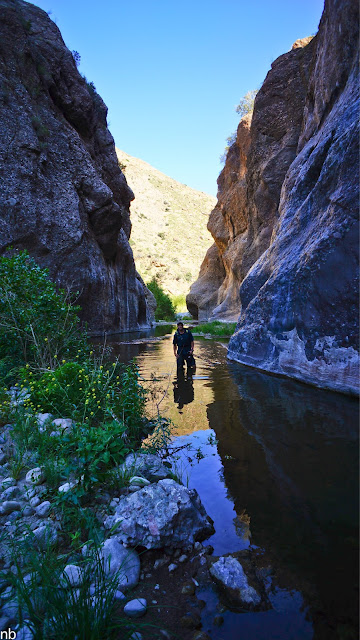
Around halfway into the canyon, the walls begin to rise up and close in.
A rare photo of myself on a hiking trip.
A big, fresh print…
Continuing on, the canyon kept getting narrower and narrower.
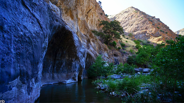
Until we finally reached a point that stopped us in our tracks… A 1/4 mile section of gorge no more than 30 feet wide in some places. This is what we had been hoping for!
The stains on the canyon walls show where the high water level is at times… Yikes!
A small 40 foot waterfall trickles into the narrows onto a sandy beach, providing a great spot for a break.
And to get some clean water. This waterfall drains a basically inaccessible portion of the Sespe Wilderness.
The HMG Porter held up well to the bushwhacking, rock abrasions and occasional mis-step on the deeper creek crossings, keeping everything inside dry and safe.
Leaving the narrows behind, we continued on hoping to reach a junction with another major canyon we wanted to explore. A peak at the topos suggested this side canyon could have some impressive waterfalls of its own.
The canyon walls and bedroom-sized boulders lining the creek are comprised of these beautiful conglomerate rocks, a bunch of smaller cobbles cemented together. The multiple colors, sizes and textures added some major beauty to the scenes.
A peak back at a brief detour around a pair of waterfalls and a deep pool.
Having reached our hoped-for canyon, we were dismayed to find the lower reaches of it dry, which dissuaded us from exploring any farther up it on this trip. Instead we opted to go for a swim, watch the bats flutter around above our heads and enjoy the last moments of sunlight filtering into the canyon.
Best we could do for a clear spot, was a narrow sandy wash. Perfect spot for a cowboy camp.
Sitting around camp, the noseeums took a major liking to me. Poison Oak doesn't bother me, but biting bugs LOVE me. I apparently have some kind of allergic reaction to noseeums because by the end of the next day, my hands and fingers swelled up to cartoon character proportions from all the bug bites. It would take a few days before my hands returned to normal.
Sunrise over the canyon walls.
Continuing on, we soon reached the stretch of canyon I had previously hiked the winter before. The last time I hiked through here, we had swift creek crossings sternum high. The knee high crossings this time and generally, lower, slower water made life quite a bit easier.
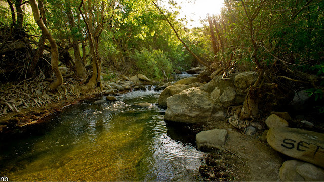
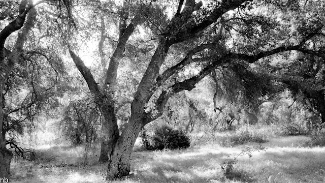
Light filtering through the oaks around an abandoned FS camp.
As we got closer toward the end of the canyon, we began to pick up remnants of an old FS trail that was let go back in the 40s or 50s. It was faint in places, and tunneled through willow thickets and forests of giant rye but it allowed us to pick up the pace. Still, at times, we were better off tromping down the creek.
Our last stop before the canyon opens back up and we join up with a real trail.
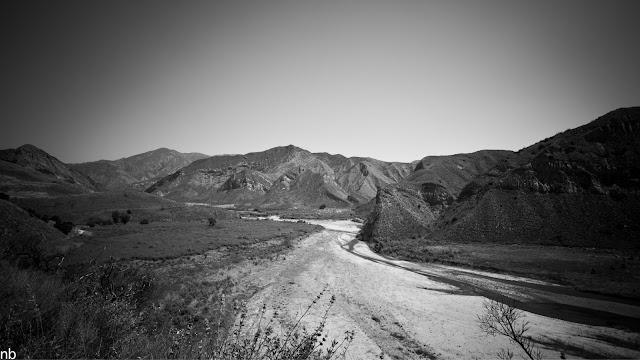
Hiking the sandy plains of the wider river valley, we encountered numerous reptiles warming up in the morning sun.
A somewhat rare Patch Nose snake.
A final look back.May 25, 2012 at 2:48 pm #1881191Nice pics, I love that spot. I've camped there many a time…Water levels look good compared to my last time out.
May 26, 2012 at 4:27 am #1881281Awesome report, Nick. You had so many amazing pictures in there that I don't even know which ones to comment on. The campsite shots in the first series made me want to be there, and I couldn't get over the blueness and clarity of the sky in the second series. Nice job all around.
I'm glad you made it out without mishap. I miscalculated my water supply once on a long trail run and remember how scary it was when I stopped sweating. Looking forward to the third installment.
May 26, 2012 at 11:53 pm #1881444Thanks Craig and Ike for the comments.
I'm learning a new camera; these three trips were my first hikes with it. Overall I'm very happy with the results and willing to accept the weight penalty for greater creative freedom and better quality pics but I'm still making lots of rookie mistakes. For example, during the Cobblestone hike, I inadvertently left the camera saturation and contrast boosted on the camera settings resulting in some over the top bold blue skies! It was clear and bright, but not that bright! Anyway, it's a fun learning experience.
I've posted up the final third part of the series (above). I like to think this last hike is the crown jewel of the three. I know it's the most special for me.
Cheers,
Nick
May 27, 2012 at 5:00 am #1881452Just read the third installment with my morning coffee. This was a perfect blend of pictures and words and it was very easy to picture myself exploring the canyon along with you- and I wanted to be there very much. Thanks for taking the time to put this trilogy together for us. I think it is a huge contribution to the BPL content, and one of my recent favorites.
May 27, 2012 at 8:18 am #1881465What a great series of hikes! Thanks so much for sharing your explorations with the rest of us!
May 27, 2012 at 8:38 am #1881468Great pictures and text of your adventure… thank you for sharing.
May 27, 2012 at 8:47 am #1881470Great stuff I really like the pictures of the reptiles.
May 28, 2012 at 2:23 pm #1881778Thanks for posting your triple reports Nick. The pxts from your new camera are beautiful. I really appreciated the details of the Fish Bowls (can't wait to get out there). Bixby is definitely the MAN.
Jun 11, 2012 at 1:23 pm #1885941Thanks for the comments everyone. Putting the time into the trip reports is a pain, but I enjoy seeing others' stories and adventures from their respective neck of the woods, so I feel obligated to do the same! Plus I like to share some fun CA hikes other than the Sierra.
@ Andy, let me know if you want to do a trip around here this winter. I've got some ideas… Maybe I'll even bring Bixby!
Jun 13, 2012 at 10:51 pm #1886774looks like a great trip!
I just went on my fist backpacking tip with a dog last month to Emigrant. It is definitely a cool experience with one. We went with a black lab who loved the water.
Great pics too!
Madison
 Jun 13, 2012 at 10:59 pm #1886776
Nick,
Simply an amazing collection of photos man. I've gone through a few times now, many gems in here. Thanks for taking the time to do this and to share this with all of us. Looking forward to some hikes in these areas, your report has sparked the fire for sure!Jun 21, 2012 at 7:08 pm #1889101Thanks for the trip report. What trailhead did you park at to get to fish bowls?
Jun 22, 2012 at 9:25 am #1889206For this trip, I left from the Fishbowls Car Camp and TH. You can also get to it from the Cedar Creek TH off the spur road to Thorn Point. These are the two "main" trailheads and are about 1 mile apart, so you can create an easy loop and go in one way and out the other. Of course, as part of a longer trip, you can get to either of these areas as a detour from the Gene Marshall Trail as well.
Jun 23, 2012 at 5:01 pm #1889577Great TR Nick. Thank you for putting in the energy into typing them up – we all know how hard that can be! Glad you're digging the new camera.
-
AuthorPosts


- You must be logged in to reply to this topic.
Forum Posting
A Membership is required to post in the forums. Login or become a member to post in the member forums!
Our Community Posts are Moderated
Backpacking Light community posts are moderated and here to foster helpful and positive discussions about lightweight backpacking. Please be mindful of our values and boundaries and review our Community Guidelines prior to posting.
Get the Newsletter
Gear Research & Discovery Tools
- Browse our curated Gear Shop
- See the latest Gear Deals and Sales
- Our Recommendations
- Search for Gear on Sale with the Gear Finder
- Used Gear Swap
- Member Gear Reviews and BPL Gear Review Articles
- Browse by Gear Type or Brand.
