Topic
The Colorado Trail – a Weminuche Alternative
Forum Posting
A Membership is required to post in the forums. Login or become a member to post in the member forums!
Home › Forums › Campfire › Member Trip Reports › The Colorado Trail – a Weminuche Alternative
- This topic is empty.
-
AuthorPosts
-
Sep 21, 2011 at 9:16 pm #1279637
"Goodbye old friend. Thank you."
I was standing at the trailhead at Spring Creek Pass, about to begin an 8 day trek. This would normally be a moment of release, when mundane realities are exchanged for the simple and direct joys of immersion in a beautiful wilderness.
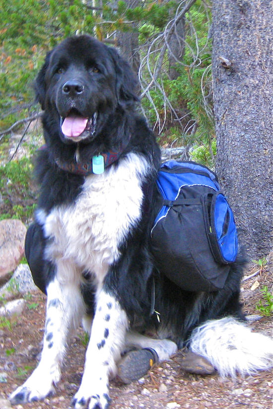
Instead, my heart was breaking. Baloo, my loyal companion for 6 years and 300 miles of section hiking the CT, had died in his sleep that night*. He was gone, his journey done, and I was devastated. He'd been my trail dog – carrying packs, fording rivers, romping in the snow, feasting on trout, slogging up trails to the high places, and gratefully enjoying the cool streams of the low places. We'd been together for countless hikes in every weather and every season all over the state. And now he was gone.
"Are you going to be OK? Are the trails well-marked for the first couple of days?" My wife Cathy was looking at me, seeing my desolation and wondering if I was still capable of taking care of myself. She'd told me last night that I should go on with the hike – I'd be even more miserable spending the rest of my vacation moping around a dog less house. And it's what Baloo would have wanted. She was right, as usual.
"Well, not exactly. The first two days have some bushwhacks. But … I promise I'll come back to you." And with that, I touched the amulet of dog hair next to my heart, turned up the trail and began to hike with tears streaming down my cheeks.
Although I was picking up the Colorado Trail where Baloo and I had left it last summer, I wouldn't be on the Trail proper for long. This stretch of the CT runs mostly along the Divide, then cuts across 5 miles of the northwest tip of the Weminuche Wilderness before dropping down to the Animas River.
This just seemed wrong to me – the premier trail in Colorado should do more than just slightly graze the premier wilderness area in Colorado. The Weminuche is the largest and most remote wilderness in the state, and arguably the most beautiful. I have the utmost respect and gratitude for those who laid out the Trail and brought it into being. I am sure there were good reasons and many debates about the best route. But I just couldn't see spending a week of hiking in this area and skipping the Weminuche. I'd spent 4 days hiking the Pine River country back in the 80's, and had always wanted to return. Now was my chance, and I was going to take it. One of the things about being over 50 is that you no longer expect second chances.
So I'd spent the winter making my plans and plotting my route. I'd start on the Jarosa Mesa, then drop down a gulch to North Clear Creek. I'd follow the creek valley up to its head, cross a low divide and meet up with the Lost Creek Trail, which could be followed down to the Rio Grande and the northern edge of the Weminuche. From there, the trail up Ute Creek would lead me into the heart of the wilderness, and I would take a circuitous route through Rincon la Osa, down the Pine River, up Flint Creek, down the Vallecito River, up Johnson Creek to Columbine Pass and Chicago Basin and an easy hike down to the Animas River to the tourist train, which I'd take back to the car I'd left in Durango.

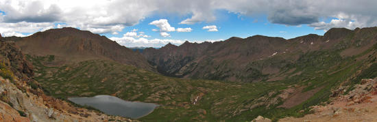
Route of the hikeSo it really is not the Colorado Trail, but I reasoned I could take the train up next year to Elk Park, and continue on the CT proper. I wouldn't have hiked the CT, but I would be hiking through country I had long wanted to see. Rather than sticking to the Divide, where I'd be short of water, short of breath and dodging thunderstorms – in addition to enjoying matchless views – I'd enjoy lush river valleys and trout-filled streams. Seemed like a more than adequate trade for the formality of having covered all of the Trail.
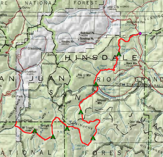
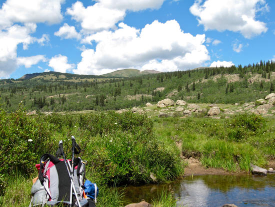
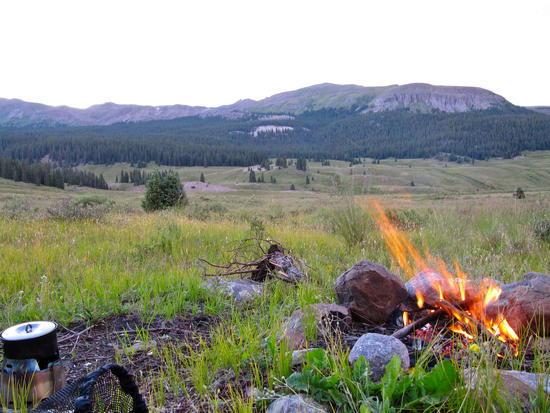
The day was fine and clear as I skirted around the south rim of Jarosa Mesa, immersed in expansive views of the Rio Grande Basin and the far peaks of the Weminuche to the south. I was looking for the remains of an abandoned trail that would cut down Buck Creek and take me to North Clear Creek. Although there was little chance of getting lost, I was hoping that the old trail would still be clear enough to save me the annoyance of clambering over deadfalls or thrashing through willow hells. This turned out to be the case, and I had an easy walk through pleasantly open glades as I descended. Once out on the flats, I turned up the side canyon of Kitty Creek to get out of the wind and made my first camp. The North Clear Creek basin is wide and open and empty – just the kind of terrain that makes you feel small and insignificant. Or to remind you that your friend and companion of so many hikes was now gone and vanished into the ether.
But my mind couldn't quite accept that he was gone. I was so accustomed to having him by my side that it seemed he was still there. Not right beside me, but somewhere in the middle distance, just out of sight, watching me. Not happy and not sad, but watching and waiting for my command, as always. But every direction I turned there was only sky and sage and wind.
The creek held some small trout, but I couldn't bring myself to cast a line to them – it seemed too frivolous, too casual and unmindful. I sat and watched them feed as the sky softened and then darkened altogether.

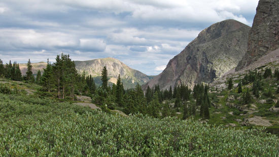
View south from JarosaMesa toward the Weminuche
Graves (of sheepherders?) on Jarosa Mesa
Looking down into the N Clear Creek valley
1st camp, on Kitty Creek
Sunrise on Kitty CreekThe challenge for the next day's hike was to find a route that was not closed off by private property. Like many river valleys in Colorado, the land surrounding North Clear Creek is in private hands, and by blocking access to the back country, turns our public lands into a private reserve. The topo map shows property boundaries, but the key question is whether the owners are ranchers or vacationers. The former generally don't care about hikers crossing their land so long as they are respectful, the latter do. The map shows trails and roads that could provide passage, but there is no way to know whether these are private or public throughways.
My plan was to follow the trail across the dam holding back the unnamed reservoir above Continental Reservoir and continue up County Road 103, but it was posted. I then walked up the west side of the valley until I came to a road passing between the Pearl Lakes which – if it were public – I could take up to the upper North Clear Creek valley. It wasn't posted, so I continued on, but then got a hostile reception from the manager of the cabin association who appeared to make no distinction between solo backpackers and itinerant beggars, as she warned me not to stop at any houses on my way off her property. Fortunately this way was the county road I'd wanted to follow in the first place, and I soon intersected the jeep trail leading back into the public lands of the valley.

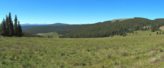
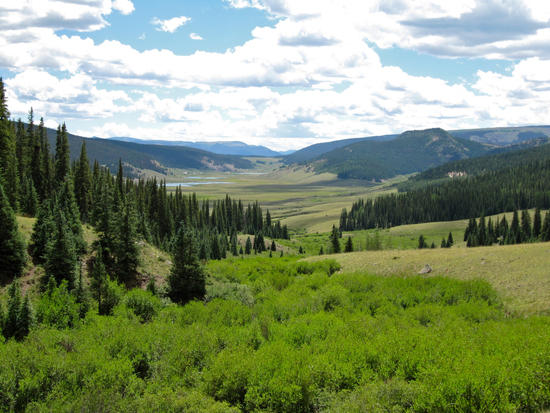
Path through N Clear Creek valleyOnce clear of the cabin association, I continued on an easy hike up the rocky valley. I watched the thunderheads build over the Divide as the afternoon progressed, and felt glad that I was not up there, exposed to the threat of lightning with no shelter at hand. Reaching the head of North Clear Creek in a brilliantly green round meadow, I continued onward and downward to meet the Lost Creek Trail, which turns out to be a popular ATV route. It began raining as I followed Lost Creek down to the Rio Grande valley. I decided to spend the night in the car campground there rather than hike another 3-4 miles to a plausible campsite along Ute Creek.
Looking up a thunderheads building on the Divide (and the CT) from N Clear Ck
Headwaters meadow on N Clear CreekThis turned out to be a big mistake. Once the temperature dropped a bit, horrible waves of sewage stench rolled down the gully, enveloping my tent in fumes that woke me several times during the night. The well-maintained campground outhouse was not to blame – I'd guess that one of the dude ranches on the other side of the creek had parked a septic lagoon nearby that kept belching out vileness. I broke camp early and quickly in the morning and headed for the ford of the Rio Grande, just a mile or so down the road.
Pinnacles above Lost Creek CG
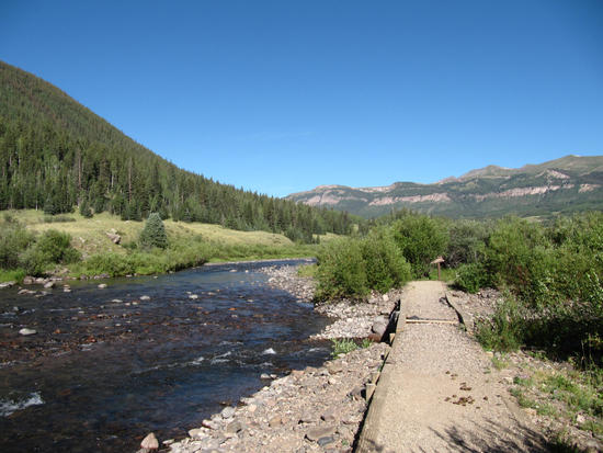
Ford of the Rio GrandeOnce across the easy ford, I was in the promised land at last. The hike from Spring Creek Pass was about 30 miles – pleasant enough, but only a prelude. Now I was ready for the real deal – the largest roadless area in the state, where I'd be on my own for the next 6 days.

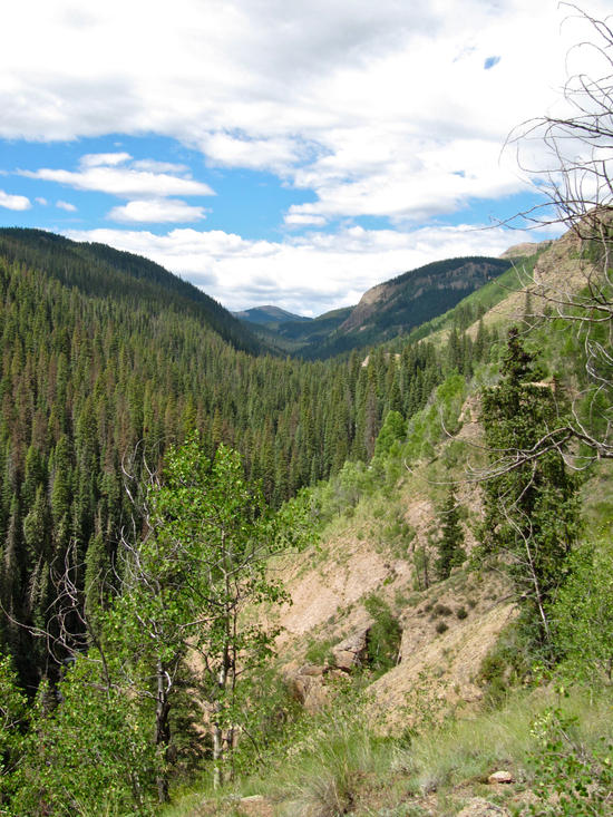
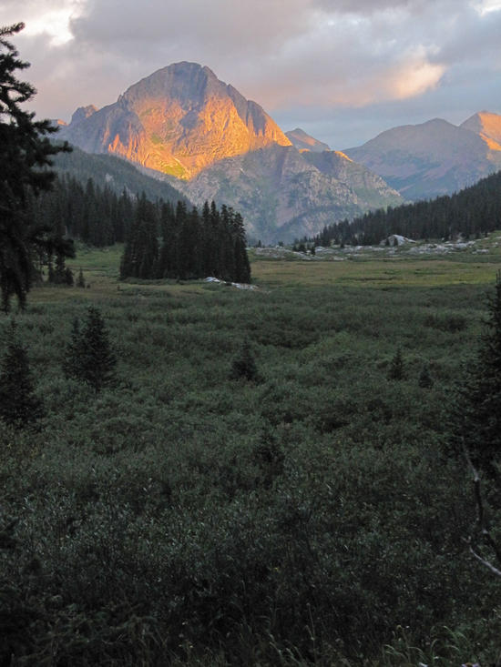
Looking up the Ute Creek canyon into the WeminucheThe steady climb up the Ute Creek valley revealed two features that were to hold for the rest of the hike – dying forests and abundant fishing. Most days I stopped for lunch at a likely spot, caught a cutt or brook, built a small fire and cooked and ate it on the spot. Elapsed time for the whole operation was never more than 40 minutes – the sort of thing that gives you the feeling, however illusory, that you could survive quite a while if need be.
That is, if you didn't get iced by a falling tree. The trail crews had done a great job of clearing the deadfalls off the trail, but it was evident that they would have plenty more work to do. In the north and central regions of the state it is the pines (mostly lodgepoles) that are being killed. Here it was the spruces, and 30 – 50% of the trees are dead or dying. The dense green forests of the Weminuche are gone, at least for the rest of my lifetime.
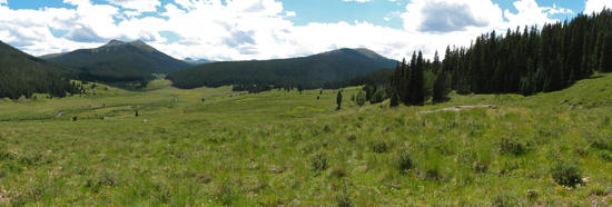
Just past the swamp called Black Lake, I broke out into the gorgeous valley where the forks of Ute Creek converge. This valley is also a key trail junction. The west fork can be followed to Beartown and a quick reunion with the CT and a quick exit from the Weminuche; the middle fork joins the CDT and thence to Ute Lake and the Vallecito River; I took the east fork, which leads to the Pine River and the heart of the wilderness. I made camp at the upper end of the valley, and after the evening's thunderstorm, sat quietly while contemplating the beauty that surrounded me.

Valley of the forks of Ute Creek
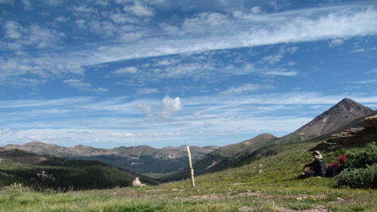
Camp at sunset on the E Fork of Ute CreekThe trail up to Ute Pass was the first real climb of the trip, scooting under the crags of the Rio Grande Window.
The soft sedimentary rock of the Rio Grande basin forms a "window" on the ridge
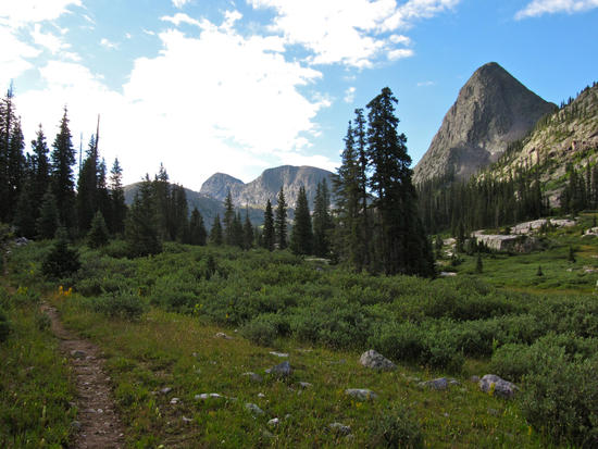
Looking back down the Ute Creek drainageThe view from the pass revealed the riches of the wilderness – forests, valleys, meadows and streams, all stitched together in a seamless display of beauty and wildness. The hike down through Rincon La Osa was an unbroken succession of wildflowers, clear springs, open skies and towering peaks. After leaving this hidden valley, the trail wound through a succession of canyons and meadows, emptying at last into the Pine River.
Rincon La Osa
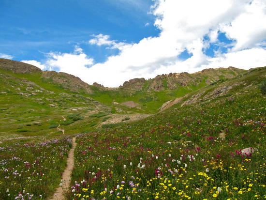
A carpet of wildflowers in the Rincon La Osa
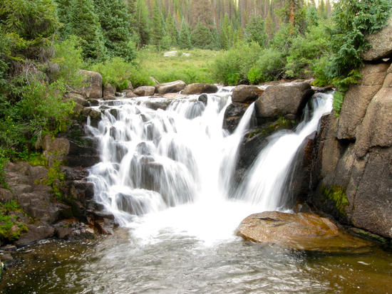
Waterfall on the Pine River, emptying into a trout-filled poolThis was the goal I had been daydreaming of not only through the winter, but for decades – to plunge into the heart of the richest wilderness in Colorado. I stopped below a waterfall to catch and eat my lunch. But I was not feeling the elation and satisfaction I had imagined. Part of the problem was the dying forest, which was in much worse condition in these lower altitudes. The other problem was loneliness – the farther I got from any road, the more I felt the void around me. Baloo was by no measure an intelligent dog – one of his favorite pastimes was dredging rocks up from streambeds and placing them on the bank – but his emotional IQ was high. He always seemed to know when I needed a laugh from his foolery, or when to sidle up and just be a friend. It had been years since I'd been without his companionship for more than a day or two, and I no longer seemed to have the resources to keep my own spirits high without him. I trudged on and made camp, but with waning enthusiasm. The high cirrus clouds I had seen at Ute Pass were now being followed by low nimbus, and an evening storm closed in just as I finished my dinner. As the wet dreary night dragged on, I felt more alone than ever.
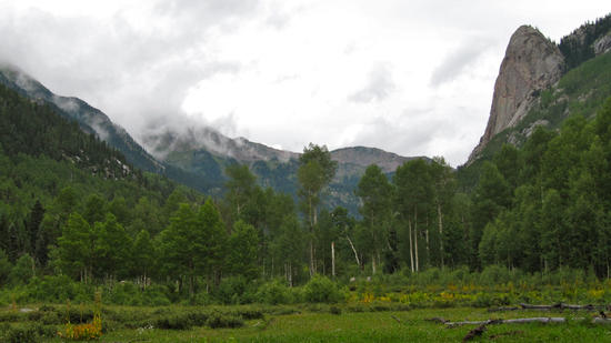
The morning was soggy and drizzly and I made no more breakfast than a cup of coffee and was quickly on my way. I had several miles of easy hiking down the Pine River, losing a thousand feet of elevation before climbing up Flint Creek. The clouds broke as I reached the junction, and I was greeted by the inspiring sight of the Pope's Nose, a polished granite tower rising up from the glaciated valley floor. A long steady climb brought me to swampy Flint Lake, and then the head of the basin. I'd planned to camp at Rock Lake, but found it too treeless and windswept for the conditions, and so continued down into the forest and camped along Rock Creek.
Pope's Nose at the mouth of Flint Creek
Looking back down the Flint Creek drainageMy choice was rewarded next morning as the storm clouds opened and the morning sun lit up The Guardian, a beacon leading me on to the Needle Mountains. The walk down Vallecito Creek was a parade past the dramatic peaks of this range. At Johnson Creek I crossed the only bridged ford of this journey, and settled into one of the finest campgrounds to be found anywhere – level sandy soil, a parklike spacing of fine trees, the beautiful river at hand, and everywhere a chorus of lofty peaks drawing my eyes upward.
Sunrise on Rock Creek
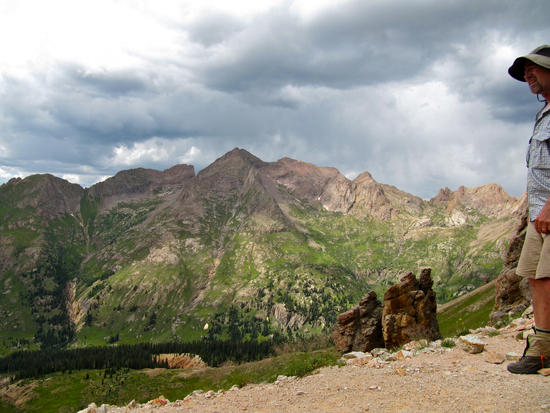
Peaks of the Needle Mountains rising above Vallecito CreekThe next day's hike took me from one of the lowest points on the trail (9100 ft) to Columbine Pass, the highest (12,600 ft). The warmth of the day made me grateful for the many cool springs along the trail. Coming straight down from steep side canyons, no filtering or treatment is needed, and I could enjoy the taste of the purest water imaginable for no more effort than reaching out my hand. The canyon of Johnson Creek opened up into Vallecito basin, pocked with mines at 12,000 feet and above. Although the mines are eyesores, they are still a source of wonder. What was it that drove these miners to search out these spots, and drag tons of mining supplies over the most rugged, harsh and remote terrain imaginable? Was it simple greed, or impoverished desperation? Those are the simple, obvious answers. Or was there more to it – was there a love of mining and the search itself? Whatever the answer, the miners seemed a race apart, whose like is no longer with us.
Trail up to Columbine Pass – every bit as steep as it looksThe trail wound up the ever-steepening walls of the basin, and topped out at last at the pass, revealing the grandeur of the Needle Peaks and Chicago Basin. This basin, surrounded by 14'ers, is one of the most overcrowded areas in Colorado, but I was glad to have seen it at least this one time. I soon found just how crowded it was, as every plausible camping spot was occupied for a couple of miles down the valley. But I eventually found a spot, and spent my last night accompanied by lurking mountain goats.

Johnson Creek drainage from Columbine Pass
Chicago Basin from Columbine Passheight="172">
Mt. Eolus
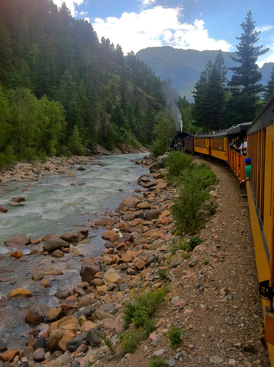
Goats in Chicago BasinI got down to the railroad by 11AM the next morning, and the conductor let me ride up to Silverton, where I checked in with my wife and enjoyed beer and tacos, before taking the 3+ hour ride back to Durango.

Train back to DurangoThe trip still leaves me with mixed feelings. I'll forever associate it with loss and grief, and eight days without human or canine companionship turned out to be too much aloneness, at least this time. But it was a great hike none the less, a trip into deep wildness that can be matched in few other places in the lower 48. Until I got to Chicago Basin, I passed no more than a dozen people, and half of those were horsebacking tourists being led by an outfitter. There was no way it could have been a happy hike, but I'm glad I had the immediate tasks of routefinding and the rhythms of the trail to occupy me. Wilderness has always seemed a home to me, and I'm glad that home was there when I needed it.
*Baloo was only seven, but that is late middle age for a Newfoundland. He'd been declining through the summer, and was having trouble walking and getting up on his own. I took him with us for a camping trip just before my hike, where he was surrounded by extended family for four days. He even rallied on the last day for a wade and swim in the Florida River, fetching sticks like old times. The next day he collapsed on the banks of the Rio Grande as we were driving to the trailhead, and died in his sleep in a tourist cabin that night in Lake City, next to the bed where Cathy and I were sleeping.

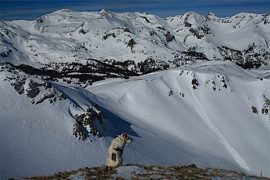
Always ready for a hike
Gone aheadSep 22, 2011 at 10:54 am #1782138Sorry for the loss of your buddy Baloo, Jonathon
Sep 22, 2011 at 12:28 pm #1782166Great post. I was up there this past summer too, but there was a bit more snow. Sorry for your loss.
Sep 22, 2011 at 12:39 pm #1782173Sounds like a great trip. I lost a buddy (Perkins) a year or so ago, who was an amazing trail dog. I know it can suck.
Sep 22, 2011 at 4:49 pm #1782270Great report! My first ever trip into the Weminuche started at the Rio Grande. I looped around the Ute Creek Drainage, gaining the CDT for quite some time. It was my first experience of not seeing a single soul for around 48 hours. Magical place for sure.
Baloo looked like a great dog!
Sep 22, 2011 at 6:21 pm #1782308Johnathan,
Thank you for sharing a beautiful trip. I'm sorry for your loss. I know he will be in your hearts always. It's quite obvious he lived a happy life as part of your family.Sep 22, 2011 at 10:31 pm #1782401A beautiful and very moving trip report! You have all my sympathy!
"We who choose to surround ourselves with lives even more temporary than our own, live within a fragile circle, easily and often breached. Unable to accept its awful gaps, we still would live no other way. We cherish memory as the only certain immortality, never fully understanding the necessary plan." Irving Townsend
Sep 23, 2011 at 3:58 pm #1782763I know this must have been a difficult trip to live, and then relive in writing, but it was extremely well written and moving. Thank you for sharing it.
I started backpacking because of an adventurous dog and can understand the hole that Baloo's passing has left in your life. I'm glad you were able to take some time alone to reflect on his life in a place that he would have loved.
You have my deepest sympathies.
Ike
Jan 10, 2012 at 5:21 pm #1822882I hiked the AT (many years ago( with my Doberman:

These past few years I have hiked in the Weminuche with, yes, my MinPin (still with me but retired from all but easy day hiking):
It is so different in the Weminuche with all the Engelmann dying. But it is still the Wilderness. Glad to hear you got back to it.
Jan 10, 2012 at 6:51 pm #1822924Jonathan,
Thanks for sharing not only your words and pictures, but a big chunk of your heart as well. We do so miss our four-legged companions, for they are so dear to us. Your cathartic trip was both a pleasure and sorrowful to read. They don't get any better than that. My heart goes out to you.
Jan 10, 2012 at 9:17 pm #1823003Thank you for sharing your story.
Jan 13, 2012 at 7:01 am #1824200Great trip report.
Sorry for your loss.
I have always wanted to have a dog to accompany me on backpacking trips. My current one is too old, and my other old friend passed away last year.
I have the Weminuche on my to do list for 2013, so this is a wonderful trip report to read for me.Ben
-
AuthorPosts


 height="172">


- You must be logged in to reply to this topic.
Forum Posting
A Membership is required to post in the forums. Login or become a member to post in the member forums!
Our Community Posts are Moderated
Backpacking Light community posts are moderated and here to foster helpful and positive discussions about lightweight backpacking. Please be mindful of our values and boundaries and review our Community Guidelines prior to posting.
Get the Newsletter
Gear Research & Discovery Tools
- Browse our curated Gear Shop
- See the latest Gear Deals and Sales
- Our Recommendations
- Search for Gear on Sale with the Gear Finder
- Used Gear Swap
- Member Gear Reviews and BPL Gear Review Articles
- Browse by Gear Type or Brand.
