Topic
Anybody hike sawtooth pass to big 5 lakes?
Forum Posting
A Membership is required to post in the forums. Login or become a member to post in the member forums!
Home › Forums › Campfire › Member Trip Reports › Anybody hike sawtooth pass to big 5 lakes?
- This topic is empty.
-
AuthorPosts
-
Jul 29, 2011 at 6:02 pm #1277402
On August 9th I am planning on doing this loop with 2 other people.
http://infolab.stanford.edu/~crespo/Pictures/sawtooth01/MineralMapT.jpg
Hike in the first day, hang out and camp for one or two days at the lakes, and then walk out the next day.
Just wondering, has anyone done this recently? What are the snow levels like? Any tips?
I have never hiked at this kind of elevation before, what should I expect? Also, how hard is the hike in terms of elevation gain?
I am also wondering if they have camps at any of the big 5 lakes, and if they have fire rings/allow fires? I want to cook fresh fish, but don't want to carry a frying pan for use with my stove unless I have to. Roasting over a fish over a wood fire would be easier, if possible.Jul 30, 2011 at 9:00 am #1764641In regards to fires Justin….Since you are at elevation I would check with rangers as to if you can have a fire. When you get your permit they will go over regulations with you. Since those lakes are close to a trailhead, I would assume that there are many places to camp around those lakes. I have never been there before but my assumption there will be places to camp. Above treeline and at a lake is to look for vegetation (trees, etc.) that is where you will usually find campsites. Looks like a fun trip. I have never done any out of Mineral King before. I have heard that the Marmots like your car hoses….they like engine coolant……
Also looking at your first day hiking it looks like you guys are in for a long day. I might be just a bit less ambitious the first day due to elevation and acclimating
Jul 30, 2011 at 10:08 am #1764654Call the Mineral King ranger station. The nice people there should be able to answer a lot of your questions.
That is an extremely ambitious hike for 2 days. (It's a 4-5 day loop for most.) The high-ish elevation at the passes is the least of it. Mineral King terrain is steep and rugged up-and-down, with little reprieve. The upper ~1500 feet up Sawtooth Pass is cross-countryish, slip-n-slide. This particular map, instead of going over the trailed Timber Gap, has you traversing Glacier Pass, Class 3 on the north side with some nasty steep snow. (I eyeballed Glacier Pass last year and decided I'd only ever consider it at the very end of a low-snow year.) After Sawtooth Pass and before Glacier Pass you also go over Blackrock Pass, a bit easier but still no joke.
Maybe a way to do it would be to just head over Sawtooth Pass on an out-and-back, and see how far you get. Columbine Lake and Lost Valley are both gorgeous places to camp if you can't get to Big Five Lakes. In fact, both of those places are more scenic than Big Five Lakes. I don't know anything about the fish situation there, though.
The whole terrain in there is gorgeous. Doesn't much matter where you end up :)
– Elizabeth
Jul 30, 2011 at 12:19 pm #1764679I have hiked across that country extensively back in the mid-1970's but haven't seen it since then. Once a year, I used to take a week-long loop over Franklin Pass to Little Claire Lake then over to Big Five Lakes Basin via the Big Arroyo and into Little Five Lakes Basin. On the way out I would cross country it a bit over the saddle just southeast of the uppermost Little Five Lake and into the Big Five Lake Basin. By staying high on the slope above Big Five Lakes basin, I would work my way over to the saddle btwn Big Five Lakes Basin and Spring Lake and drop into Spring Lake. This let me avoid Blackrock Pass coming out of Little Five Lakes Basin. I would time the trip to overnight at Spring Lake and then tackle Glacier Pass on the last day of hiking.
My typical timing for this trip was late in August or early in September and I never had any problems with snow along the route. Unfortunately, I don't know about the current snow conditions since my days of taking long hikes well above treeline in the High Sierra are now past me. Good luck up there. I still have found memories of the great high country I hiked thru out of Mineral King.
Jul 30, 2011 at 12:38 pm #1764682I went to Big Five Lakes in summer of '09. Really nice area. The trail marked in the Big Five Lakes area is semi-non existent. Tough to follow. But no matter, it's relatively easy XC.
We found plenty of places to camp. Not sure about fires. Fire regs are by basin by elevation. They're probably OK in Big Five because it doesn't get a lot of visitors, but check with Mineral King R.S. like everyone says. Fires are prohibited in Little Five Lakes Basin.
Getting all the way to Big Five Lakes in one day via the XC route over Glacier Pass is ambitious. It can be done; just depends on what kind of shape you're in. If you're used to 15+ mile days and XC travel, it shouldn't be a big deal. Using what I call Five Lakes Pass (described in a post above) is definitely a good idea. There are a couple of class 3 moves needed. Very no big deal to get over Five Lakes Pass. A bit steep going down the other side, but typical Sierra XC stuff.
I found Five Lakes basin to be well worth visiting. One of the highlights of our trip.
HJ
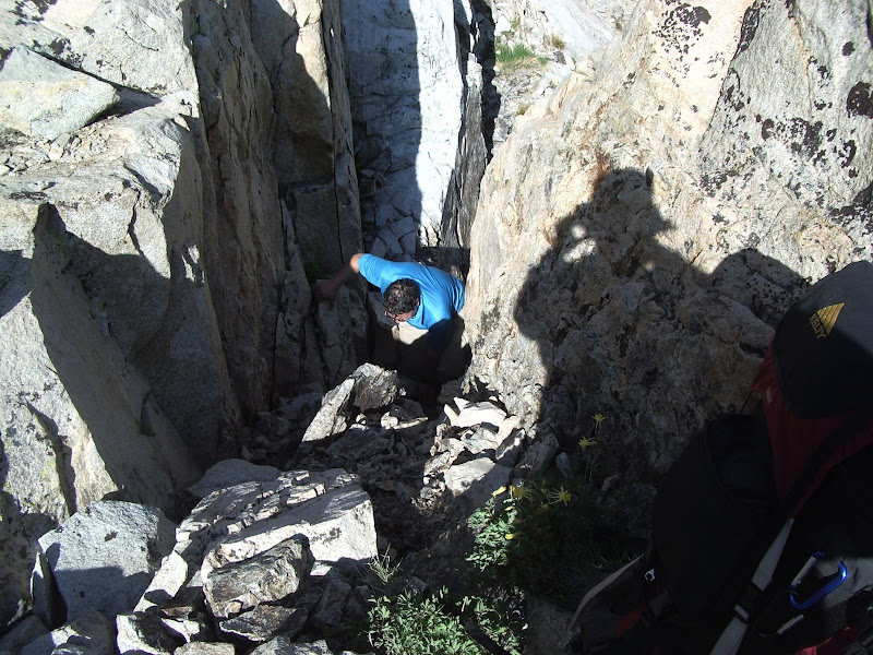
Jul 30, 2011 at 12:53 pm #1764683Ascending from the north Five Lakes Pass (between Little Five Lakes and Big Five Lakes). Generally class 2, with maybe one or two class 3 moves.

Five Lakes Pass from just below the pass.
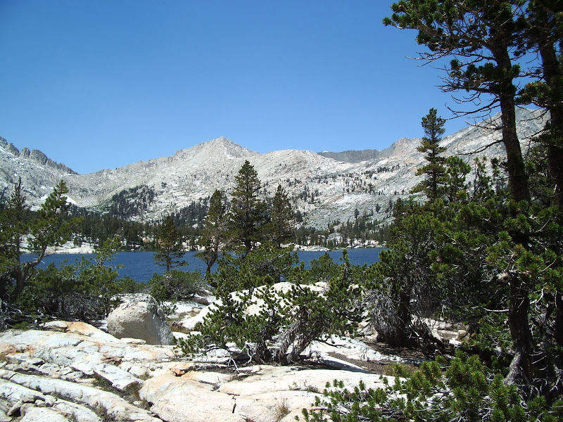
Looking out over the Big Five Lakes basin.
Beautiful Lake 10,214 in Big Five Lakes
Looking up canyon from lake 10,192.
Lake 9830 from the outlet stream.
HJ
Jul 30, 2011 at 2:14 pm #1764693Wow, thanks for all the replies guys. According the larger, national geographic map I have, it's about 11 miles to the lakes. I thought it would be a hard hike, but it's sounding pretty rough. While we are all in good shape and young, none of us are
accustomed to really long distance (20+ mile) hiking. Would we be better off sleeping at columbine lake and then taking it all the way to big 5 the next day? We are staying the first night by the trail head and going to wake up at 8 or 9 to pick up the permit. So we would have all day. Would anywhere in lost canyon be a decent place to camp? Honestly, I originally though that 11 miles would be very reasonable and not rushed. The most I have ever done in steep country was 15 miles in a day going up ascending 5 thousand feet(really straight up), but I was pretty kapoot after that.If we ended up at the lakes, would we be much better off coming out from sawtooth pass or would it be comparable (provided that snow levels were down) to come out the other way? (i terms of length and difficulty) While stepping in snow is not a big deal for us, anything technical, like requiring cramp ons, is a big no for us. Also, I noticed that galcier pass looks off trail. What is that solid black line coming off the north side of spring lake? I am assuming that's a stream or creek of some sort? Easy to follow? Am I going to get turned around trying to go over glacier pass if I have never been there before?
I'm not so concerned about finding a camp, but I figured If I found a camp and a fire ring, that would be a sure sign. I am assuming that if there were no camps in site, I could camp wherever (right?) I called the ranger station, but honestly the people sounded confused and maybe they didn't know what they were talking about. So I figured I would ask people here who had possibly camped there before and knew.
Here is the text straight for the official website.
SEQUOIA NATIONAL PARK
No campfires at the following locations:
Kaweah River Drainage
• Above 9,000 ft. elevation
• Hamilton Lakes Basin
• Mineral King Valley above the Ranger Station
• Pinto Lake
Kern River Drainage
• Above 10,400 ft. elevation
• Above 10,000 ft. elevation at these specific locations :
-Nine Lakes Basin & Big Arroyo areas
-At Lower Crabtree Meadow, within ¼ mile of the food storage locker
Tule River Drainage
• Summit Lake Basin
• Dillonwood Area"Mineral King valley above the Ranger Station" I have no idea if that would refer to big 5 lakes, I would think not considering its over some big hills, through some mountain passes, ect. Maybe you guys could make better sense of that text.
One of the lakes is at 9800 feet, well below any posted regs. In general, would you get in trouble for making a fire outside of a fire ring? Or would using a wood stove with a bottom to it be "ok" with the rangers? Obviously I would keep it small, stomp out all the coals into a fine powder, and bury it to not leave any trace.Anyways, thanks for all the info, it's helping a lot.
Jul 30, 2011 at 2:26 pm #1764696"I would work my way over to the saddle btwn Big Five Lakes Basin and Spring Lake and drop into Spring Lake."
That's actually an interesting idea. I will keep that in mind in case we need to take a shortcut.Jul 30, 2011 at 7:57 pm #1764775As for the glacier pass, the snow levels have been extremely high this year. Perhaps I would want to avoid that.
Aug 1, 2011 at 10:46 am #1765171Do you have R.J. Secor's book? "The High Sierra: Peaks, Passes and Trails." This is the authoritative book on x-country passes in the Sierra.
In case you can't get it in time, I'll read you some info on the passes in question.
1. Glacier Pass – yes, this is off-trail. From Secor: "11,080+ ft. Class 3. This route connects the Sawtooth Pass Trail with the Black Rock Pass Trail via Spring Lake…From Groundhog Meadow along the Sawtooth Pass Trail (8757 ft) leave the trail and hike directly up the slope above. (Alternatively, you can remain on the Sawtooth Pass Trail beyond Monarch Lake.) You eventually regain the Sawtooth Pass Trail below Sawtooth Pass. At the point where the trail switchbacks to Sawtooth Pass [note: it's more like a confusing smattering of 10 different use-trails], leave the trail and head for the saddle to the north. The north side of Glacier Pass is a short, steep cliff, which usually has a small snowfield until late in the summer; in the spring there may be a cornice blocking the way. Descend on the north side of the pass and go down to Spring Lake, circling it on its north side. Remain above the 10,000 foot contour and make a level traverse to the Black Rock Pass Trail."
"When approaching Glacier Pass from the north, follow hte north side of the stream that feeds Spring Lake to the tarns in the meadows below the pass. During low snow years it may be possible to skirt the snow on the right (west) side of the pass by climbing steep talus."
I hope someone who has done this pass can chime in. Having eyeballed it from both the north & the south sides, it looked very easy navigation-wise (everything is line-of-sight), but that snowfield on the north side looked freakin' steep and exposed, and still substantial in August last year.
2. Cyclamen Lake Pass – this is the pass that goes west from the Big Five Lakes basin, and then down to either Spring Lake or Columbine Lake. Secor's description starts at Columbine Lake. "11,145 ft. Class 3. This pass has also been called 'Hands and Knees Pass' and 'Bunny Ears Pass.' This difficult cross-country route leads from Columbine Lake to Big Five Lakes. (It is the author's experience that it is easier and faster to hike down the Sawtooth Pass Trail through Lost Canyon and then take the Big Five Lakes Trail.) From Columbine Lake, cross the shallow pass to the north and descend steep slabs and talus to the east shore of Cyclamen Lake. Make an ascending traverse from the lake to Cyclamen Lake Pass; this involves more steep slabs and talus. From the top of the pass…descend to Big Five Lakes."
3. The third pass, already mentioned by someone above, is the unnamed pass between the Big Five and Little Five Lakes basin. That one (to the eyeball) looked easy and fun. I wish we had done that, instead of taking the somewhat boring official trail through the woods between the two lake basins.
You actually sound like a strong group of hikers, but if you aren't sure how far you can go on day 1 given the altitude and the ruggedness of the trails (even the official ones) in Mineral King, I stick by my recommendation to just go over Sawtooth Pass on day 1 and see how far you get. The climb to the top of Sawtooth Peak is a must-do side trip, for many. Columbine Lake is a stunning place to camp! Lost Canyon is gorgeous too, although there were fewer obvious camping areas there, and it's meadowy so there may be skeeters. But Columbine or Lost Canyon or even the lowermost Big Five Lake are all attractive and convenient camping bail-outs should you not make it all the way into the main Big Five Lakes Basin on day 1.
From Big Five Lakes, you will have some options. Personally, I say don't miss the uppermost lake in Little Five Lakes Basin, nor the descent down Black Rock Pass to the west. Gorgeous. From at or below/west of Black Rock Pass, you'll have a line of sight to that snowfield below Glacier Pass. If it looks do-able, you can go out that way. If not, you do the longer walk, on-trail, via Pinto Lake and Timber Gap, back to your car. (This trail walk is only partially shown on the map you linked; but it's well-marked and will be fast walking compared to your last few days).
– Elizabeth
Aug 1, 2011 at 12:07 pm #1765203Thank you Elizabeth! I don't have a problem with snow, it's not the end of the world, but i'm not exactly prepared thrown on cramp-ons and ice axe my way up a slope.
I wonder if I go over the saddle between the big 5 lakes basin and spring lake, if there is anyways to get to mineral king without going over glacier pass? If it's impassible, we either have to come out the way we came or go the long way… keep going left and not take the turn off up the creek to spring lake, take the extra miles for a longer loop around. That's 11 or 12 miles from the big 5 lakes, but I don't see why we couldn't do that in a day unless the hiking is just really difficult.Aug 1, 2011 at 6:22 pm #1765339The alternate to Glacier Pass is the one I mentioned: Timber Gap. Basically, from Spring Lake you continue downstream (westward) along the Black Rock Pass Trail past Pinto Lake, and to a junction that then takes you south/southwest over Timber Gap back to your car. It is a lot of miles, and some elevation, but *all* of it is trailed, fast walking.
It'd be easy to see this option if you had the map. Get Tom Harrison's Mineral King trail map; plus the 7.5-minute Mineral King quad. Both should be available at the ranger station where you get your permit.
– Elizabeth
Aug 1, 2011 at 9:42 pm #1765399Ok. That's what was my initial plan, but to go over blackrock pass first. This sounds like a decent shortcut. However, I would like to do a full loop if we have the time/energy and go through blackrock pass.
Aug 12, 2011 at 12:56 pm #1768718So, unfortunately the trip ended in failure. The elevation just murdered us. It took us 6+ hours to get to monarch lakes. We had to take a long break at almost every switchback. Just brutal. We had to stop at the lakes around 4 because of elevation sickness.
The next day we attempted Sawtooth Pass but we were stopped in our tracks. We just couldn't do it. One guy was doing fine, but me and the other guy were doing bad. We could only take like 10 steps before we were panting and I was seriously losing concentration and motor skills. We just pulled out and called it quits.The elevation was the only thing stopping us. I have done things that were comparable or much harder at lower elevations and I was fine. For example, doing Mount Saint Helena, 5 miles, 3k elevation gain, in 2.5 hours and then 5 miles down. I have no idea why the elevation affected us so bad.
Anyways, pretty bummed that I couldn't get where I wanted. I will probably try again when I am in better shape and plan for much more time. Probably solo, so that I can go at my own pace and wont have to adjust to others or have others adjust to me because of variable reactions to elevation.
-
AuthorPosts


- You must be logged in to reply to this topic.
Forum Posting
A Membership is required to post in the forums. Login or become a member to post in the member forums!
Our Community Posts are Moderated
Backpacking Light community posts are moderated and here to foster helpful and positive discussions about lightweight backpacking. Please be mindful of our values and boundaries and review our Community Guidelines prior to posting.
Get the Newsletter
Gear Research & Discovery Tools
- Browse our curated Gear Shop
- See the latest Gear Deals and Sales
- Our Recommendations
- Search for Gear on Sale with the Gear Finder
- Used Gear Swap
- Member Gear Reviews and BPL Gear Review Articles
- Browse by Gear Type or Brand.
