Topic
Unsupported/Unresupplied/Thru-Hikes
Forum Posting
A Membership is required to post in the forums. Login or become a member to post in the member forums!
Home › Forums › General Forums › Philosophy & Technique › Unsupported/Unresupplied/Thru-Hikes
- This topic has 108 replies, 35 voices, and was last updated 8 years, 4 months ago by
 Cayenne Redmonk.
-
AuthorPosts
-
Nov 17, 2006 at 8:47 pm #1367530
Sam-In laymen’s terms:
RER-This stands for respiratory equivalence ratio. A participant wears a mask and sits on an exercise bike. As they pedal, the mask captures the amount of oxygen they are breathing in and the amount of carbon dioxide they are breathing out. The ratio of these two gases is then used to calculate the fat and CHO percentage being used as fuel. Protein is not used as a fuel source if you are taking in adequate calories. Based on the ratio of fast twitch and slow twitch muscles you inherited, you cardiovascular condition, etc., this set of numbers will vary for each person and sometimes significantly. For backpacking it is normally OK to just use the mean values.
MET-This stands for metabolic equivalent. When you are at rest the energy you burn is referred to you basal metabolic rate (BMR). When you exercise the amount energy goes up to some level. By dividing the energy exercising / the energy at rest the MET rate is determined. For a given activity, the Calorie expenditure and the mix of fuels are being burned are unique for each person. The MET ratio is surprisingly consistent. A large number of hiking and backpacking MET ratios for different speeds, terrain, and pack weights have been analyzed and published by various sources.
Nov 17, 2006 at 9:23 pm #1367532Richard,
Thanks for taking the time to work out the data on me.Remember that I also use
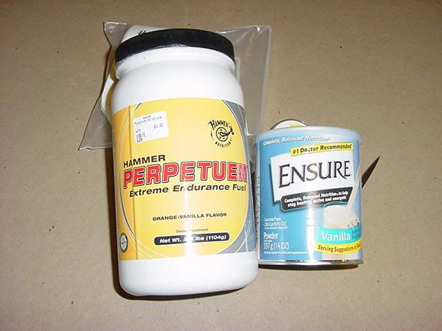
Hammer Perpetuem in all my water at half strength or about 130 calories per 1 liter of water.On my hike in Georgia last month I used both the Dry Ensure/ Carnation Drink mix for food and the Hammer Perpetuem in my water. This seemed to work really well.
While I am sure I could not do this in 3 re-supplies I might be able to do it in 5.
I did divide the 2175 miles into three segments.
1. Springet Mt, GA to Daleville, VA. 714.3 miles
2. Daleville, VA to Pawling, NY 716.8
3. Pawling, NY to Mt Katahdin, ME 743.9This could change but it would give you 3 segments.
IF, I was doing this in 5 resupplies I would want to apply a little stratagity according to the terrain. I would try a shorter first section to gain strength and get my trail legs. Then add mileage to each of the middle segments and then another shorter last segment or the Maine section. Some parts of the AT have terrain that would lend itself to higher mileage and could be longer than 1/5 the distance.
I think five resupplies would give me a pack weight of around 40 pounds on day one of each segment. I can’t even think about a pack weight of 70 plus pounds. A start date needs more thought and I might have to reschedule a couple of my up-coming medical exams. A start date of 1 April would be a good date for planning at this time. I would also plan between 100 and 110 days to do the hike. It would be nice to do it under 100 days and as the hike progressed that might even happen. Baxter State Park starts letting hikers climb Mt Katahdin on or after 15 May each year. A start date of around 1 April and a 110 days to hike the AT would put a person on Mt Katahdin on or about 19 July.
As an after thought some time also needs to be planned for the four resupply orgies, book signings, pod casts, TV interviews, etc, etc.
Nov 17, 2006 at 9:31 pm #1367534Bill-In between planning for your: four resupply orgies, book signings, pod casts, TV interviews, etc, etc <grin> I need one additional key piece of information from you or someone that has done this hike. What is the terrain like? You metabolic rate is the lowest walking moderately level ground (what % of the hike). It goes up in hilly terrain (what % of the hike?), and it is the highest when you are climbing a mountain range to get over a pass (what % of the hike?).
Nov 17, 2006 at 9:39 pm #1367535Richard,
I don’t think I am the best person to try and answer the terrain question.
Nov 18, 2006 at 7:07 am #1367552Richard, what is your background? You have a very analytical approach to problem solving, so I was figuring you are a scientist?
Nov 18, 2006 at 8:31 am #1367555John-I am not formally trained in any of the disciplines that I post to the forum on. My degree is a BS in Information Systems Management. My resume includes 14 years in software engineering followed by the remaining time in computer/software marketing and sales.
The forum topics I contribute to contain primarily self learned information. Take my theories with a grain of skepticism and challenge anything that appears wrong. Not that I needed to make that point <grin>.
Nov 18, 2006 at 11:22 am #1367577Do the folks interested in this thread have any good bookmarks of some common MET ratio tables located on the Web?
I’d be interested in applying my personal statistics into a table to see what my fuel consumption needs would be throughout a day, week, month.
Nov 18, 2006 at 1:14 pm #1367583Richard,
Can you work your model backwards? For instance, what parameters would sastisfy walking the PCT across Oregon and Washington, say, in a month and a half, without resupply?
I guess what I am asking is, if given age, and the other physical parameters that a person is “stuck with”, could you tell us what level of exertion or effort will be required to do a big challenge like 1100 miles in 6 weeks?
It would be interesting to know……
Nov 18, 2006 at 3:05 pm #1367587Roman,
Based on what you accomplished during the Artic 1000, your capabilities are obviously at the very elite end of the athletic spectrum… congratulations for your achievement. I don’t have your (age, weight, height, and VO2 max) stats. In the absence of this information I will use Ryan’s stats for your analysis. I will work backwards and then post the results within the next couple of days.
Richard
Nov 18, 2006 at 5:51 pm #1367598Food and Related Items for the Hike:
Since all my food has to be liquid, well I can eat a few soft things if I am careful, I have an interest in higher mileage between resupply stops. I can’t just walk into many stores and buy Dry Ensure. To do an AT Thru-Hike or a very long hike of any kind I had planned to do a lot of mail drops. In the early planning I thought about just doing my resupply when I walked through a place with a Post Office or a store that would hold a food drop for hikers. The idea of going into town after town has very little interest to me as I can’t eat the kind of food I would find there.
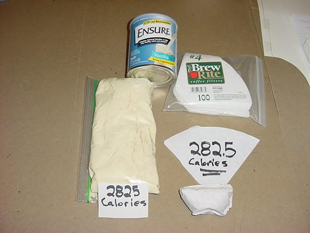
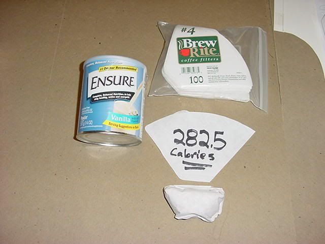
This idea of only a few resupply stops wither it is 3 or 5 or 10 plays into my food needs. I am sure I can not nor would I even try a 3 resupply AT Thru-Hike “this time”. I might think about 5 resupply stops. That would give me a average food weight at the start of each of the sections of about 33 pounds. I was surprised at the large volume that amount of food was going to take up in my pack. My Dry Ensure packs a lot of calories in a small package. A one serving size is 282.5 calories (2.29 ounces) will pack into a coffee filter and be about 2″ square for planning. The zip lock bag in the picture is 10 servings or food for one day (2825 calories). I am using Hammer Perpetuem in all my water and that will add about 520 more calories a day for a total of about 3345 calories a day.
Nutritional information for Dry Ensure:
Nutritional information for Hammer Perpetuem:

Multi-Use in action:
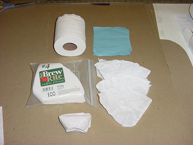
On the second half of my hike in Georgia last month I started packing my Dry Ensure in large paper coffee filters. It made my every 90 minute food stops go much faster. The paper coffee filters also turned out to make great TP. That saved a little weight and got rid of the filter. The paper filter will burn nice if I need something to start a fire with.
Nov 19, 2006 at 12:47 am #1367622Bill, that may be yet another “Fornshell-First”!! Very clever dual-use of the coffee filters.
Nov 22, 2006 at 2:33 pm #1368081I am new to this lightweight camping but I think you guys and gals are making this to complicated. What you need is an increase in knowledge and then you can go unsupported for long lengths of time. If you know your camping area you can learn the edible plants in that area. The food you carry can help supplement this gathering. It is now illegal in most places but at one time you could also hunt and set snares for meat.
Nov 22, 2006 at 2:53 pm #1368086In summary this analysis, concurs with Ryan’s assessment that the AT can be done unsupported in three segments by using ultra-light backpacking equipment and techniques.
The first chart is a composite of 4 simulations I conducted to answer the question, “What is the theoretical maximum unsupported backpacking segment distance for the AT?”
If this activity were an Olympic event, the record unsupported segment would stand at ~ 1035 miles. The average winner each year would probably be closer to the Artic 1000 team’s simulated results than the record holder’s.
The exceptional three athletes, who participated in the Artic 1000 event, would achieve ~ 921 miles. Their physiological characteristics, combined with there backpacking knowledge, are quite exceptional.
The average male is defined by ISO 8995 (2004). I have defined him in the simulations as Average 30 Year Old Male. He would be able to achieve ~754 miles. I also attached a physiological profile from the output of my simulator for this theoretical individual. I believe that the average BPL forum participant is closer to this profile than the other three.
I used Bill Fornshell to represent the physiology of an exceptional 66 year old. Bill’s VO2max of 42.46 is in the Elite class for his age range. Bill's number is ~742 miles. Obviously any individual with special diet requirements should consult their physician before attempting what the model suggests.
Bill defined the AT segments as follows:
1. Springet Mt, GA to Daleville, VA. 714.3 miles
2. Daleville, VA to Pawling, NY 716.8
3. Pawling, NY to Mt Katahdin, ME 743.9Each segment is less than what could be achieved by the average 30 yr old male using only what is in his pack. As long as he paces himself to the specified exertion rate, he shouldn’t require excess body fat.
In order to maximize the model execution time, I used table lookups extensively. The table values are rounded and consequently some totals will vary a few % from just adding up the reported substrate utilization.
This AT model is a prototype product which I designed. This is its first set of output scenarios. It is labeled as revision .1 to reflect the prototype status. If you see an unreasonable equipment assumption, suspect an error, or you have a suggestion for presenting the information more clearly, please email me with your suggestions. I will attempt to incorporate them, rerun the simulation in question, and post the new result. Each model revision will increase the revision level by .1. Only after a real AT unsupported segment attempt closely matches the model results would I feel justified to changing the revision level to 1.

Nov 22, 2006 at 3:13 pm #1368088 Nov 22, 2006 at 3:52 pm #1368091
Richard –
Those are some very useful charts. You’ve given a nice broad range of individuals to base oneself against. I haven’t heard many women chiming into our conversation but if they did they may feel left out.
Below is a Web site I found that suggest ways of calculating ones V02 Max.
Nov 22, 2006 at 4:05 pm #1368093Richard,
I really should be working but hey it’s almost Thanksgiving so what the heck.
I want to know, have you actually hiked any of the AT? I occasionally love to dwell in the land of the theoretical, metaphysical or the “way the hell out there”, but you’re numbers extend well beyond my rational limits. While I admit I don’t know the difference between a VO2 max and well most other scientific terms, I do know a thing or two about thru-hiking and the AT.
Case in point: Primary Surface – Hard pack dirt and rock.
I thru-hike the AT in ’77 at the age of 24 and did another 700 miles in ’97 and I don’t remember much “hard pack dirt” trail. The PCT yes, the CDT yes again, the AT seemed to have a lot of moss covered rocks, roots, boulders, steep sharp climbs and descents and the occasional flat but probably muddy section of trail. In ’77 I got so frustrated with the rock in Pennsylvania that my wife had a tee shirt make of my favorite saying while traversing that state, “Pave the AT in PA”.
As to the idea that your average 30 year old can carry a 76 pound pack for a distance of 36 miles over 12 hours over terrain like that seems to really stretch the imagination. My guess is your average hiker carrying those weights at that distance would be looking at knee replacement surgery by the time they were leaving Georgia after 2 days of hiking.
Having known and talked to hundreds of AT hikers over the years, my guess is that your average AT hiker currently carries an average 35+ pound pack and covers 8 to 10 miles a day, slowly gaining more distance as they get into shape. On the other hand your average PCT hiker has a slightly lighter pack and probably averages 15 to 18 miles a day at the start. The primary difference between the two is that the PCT hiker generally has a bit more experience and the trail is easier to maintain a consistence pace on all grades.
Brian Robinson trained daily for over a year to get into shape before he started on the AT. His pack probably never more than 25 pounds (due to frequent re-supply) and he found maintaining 30 miles a day difficult. Also while Brian ate a constant 3 pounds of food per day, he supplemented his diet by eating additional calories in town while doing re-supply. As a result his starting weight and ending weight after 7200 miles was the same.
What would be interesting is what kind of advanced training regime it would require to get into good enough shape to even contemplate such an endeavor. Physical conditioning is far more important factor in the success or failure during the early stages of a long distance than pack weight. Yet it’s rarely discussed, even in thru-hiker gatherings. Most thru-hiker are so busy doing all the things necessary to take off the 5 months to hike that conditioning generally gets ignored. The beauty of a long hike is that if you take it slow you can get into condition while on the hike.
Well back to work.
RonNov 24, 2006 at 7:01 am #1368244I tested the average female, as defined by ISO 8996 (2004), in my AT simulator. It shows 758 miles as the limit for unsupported travel.
 Nov 24, 2006 at 7:16 am #1368246
Ron wrote:
>> I occasionally love to dwell in the land of the theoretical, metaphysical or the “way the hell out there”, but you’re numbers extend well beyond my rational limits.
Six months ago, I might have agreed. However, after watching Roman walk unsupported for 620+ miles over the terrain of the Alaskan Arctic, I think someone with similar fitness could walk on a trail without support for 700-1000 miles.
Extrapolating from 600 miles in the Arctic, which requires navigation that is difficult on the microscale with high consequences for bad decisions (tussocks! brush! water!) and sopping wet ground cover, to 700+ miles on trails that don’t require navigation…shouldn’t be a stretch.
On the flip side, I’d argue that the AT’s hardpack is a liability on a trek like this. I have zero desire to carry a heavy pack on a paveway, knowing full well that each step is going to destroy my feet just a little bit more because the ground isn’t giving way at all and providing shock absorption.
This is why the AT or PCT will be “easy” hikes for speedy thru-hikes with light weight but very difficult walks to do any meaningful distance without support with a heavy pack.
600 miles in the tundra with no trails or 600 miles on the PCT/AT? I’ll take the softer ground of the tundra, thank you!
Nov 24, 2006 at 7:30 am #1368249Just curious, what were the cumulative elevation changes per linear mile traveled on your Artic Trek? *IF* not much, how will the dist. covered over that Artic Terrain cp. to the AT’s frequent elevation changes in some places. Also, correct me if i’m wrong, but i think, in BF’s case, he is planning his hike when the trails might be very soft and muddy at times and in places?
Nov 24, 2006 at 9:49 am #1368261Ryan,
I don’t disagree that a committed hiker can do amazing things. Both Brian and Matt’s single year Triple Crowns proved that point well beyond any words I can come up with. A year before Brian’s hike he told me his plans and I told him he’s crazy. So when we talked after his hike I consumed lots of crow.
Richards charts refer to the average 30 year old male and female (thanks to the recent addition). From my reading, this leaves the impression that if you fall into one of these categories you can load up with the recommended gear, food and head out for a 700 plus mile hike without re-supply. It may be true from the point of view of calorie consumption. I don’t know I’m not a physiologist. Though from practical experience, I’d say more calories are probably required than listed.
I do think it represents a starting point for discussion. But there’s a significant difference between walking 700 miles around a track and doing so on mountain trails over a wide range of conditions.
As to comparisons between the Artic hike and an AT or PCT hike, I lack the suitable knowledge. Having never hiked across Artic tundra I don’t know its effects on one’s hike. However, I do know the AT, PCT and CDT quite well and can pretty well predict how well the average hiker will fair on those trails. While it is relatively easy for a conditioned hiker to be able to sustain a 3 mile and hour pace going up or down hill on the PCT or CDT, the same can not be said about the AT. Both the PCT and CDT are reasonably well graded trails with the CDT being composed of miles of old jeep tracks and forest roads.
The last thing I’d like to point out is that your Artic trio were anything but average hikers. I thoroughly read through your posted training regimes. Assuming you maintained anything close to your stated regime, you’d fall well outside of the norms. The same could be said for Brian Robinson, I’m afraid I don’t know Matts pre hiking conditioning.
I would like to see more discussion on training or conditioning techniques in the pages of BPL, though I understand that it is quite difficult to do. The fact is that there has been little scientific study of long distance hikers either in terms of physiology or nutrition. I’ve known of a number of people who have attempted this only to abandon the effort. Long distance hiking isn’t a competitive sport and doesn’t attract the level of scrutiny of distance runners. Plus it’s extremely difficult to track a wide range of people over 1000’s of miles and for up 6 months.
Ron
Nov 24, 2006 at 10:34 am #1368266Ron –
Richard pointed out early on in this thread that he didn’t have any solid information regarding the elevation profile or trail quality of the Appalachian Trail and was hoping that information would be provided by someone such as yourself who has hiked it (preferably more than once).
Also when he refers to the “average hiker” I believe he is referring to only a handful of the statistics on the chart, age, V02 max, weight. The distance traveled per day could only be achieved through a lengthy training process such as Robinson’s.
Your opinion about the legitimacy of theoretical vs. actual hiking statistics is lauded but do take into account that for barriers to be broken down the theoretical must be contemplated and attempts at actualizing them undertaken.
What’s the saying?, “No pain no gain!”
Nov 24, 2006 at 2:27 pm #1368284Ron-Thank you for your valuable contribution of characterizing the relative trail surfaces for the AT, CDT, and PCT. I will factor in your AT trail surface characterization and rerun the model.
As Sam mentioned, I was aware that this information was needed to achieve better accuracy. I started to look at this theorectical problem on 11/17/06 after Ron Bell’s post in which he said in part, “I’d love to see someone do all the calorie and gear math to break it down to see what’s theoretically possible.”
Before beginning the task, I posted three times to this forum thread on 11/17/06 asking what the AT trail surface, etc. was like. I didn’t receive any response within the ensuing 5 days, I worked on the AT model part time. I posted the preliminary model results, sans the trail specific surface information, on 11/22/06.
Nov 24, 2006 at 4:49 pm #1368292Ron, we agree regarding differences between the AT and the PCT/CDT. I think the AT tends to get slammed because it’s the low elevation hike that everyone does. But my experience on those three trails indicates that the elevation changes alone give the AT some of its challenge.
Ridgewalks are hard. There are lots of ups and downs on the AT that really beat you up, even down south, that you really don’t have on the PCT. You have quite a lot on the CDT if you actually stay off the official route and enjoy the ridge!
Nov 25, 2006 at 4:12 pm #1368347The discussion of how far it’s possible to go without resupply is interesting. But I’m curious – why such a focus on preexisting trails (like the PCT and AT)?
If you’re going to be crossing roads and passing through towns anyway, why not resupply?
It seems like the real strength of this kind of thinking is for all those places in the world where resupply is difficult or impossible (like the Arctic trip). Being able to go 700 miles without resupply opens up all sorts of new possible routes in Alaska, Canada, probably Russia, maybe in the Amazon, etc…
Otherwise, aren’t you just carrying a heavier pack than neccessary?
Nov 25, 2006 at 4:31 pm #1368352Erin – I wholeheartedly agree. But the existince of the long trails are very helpful as a training ground for longer, riskier walks.
I “practiced” a few of these before I was comfortable doing a true roadless long walk.
And, I’ve had some long walks w/o resupply that have crossed 2-3 roads in 300+ miles, but the road crossings provided very inconvenient resupply options. This is common throughout my long treks in the Yellowstone Ecosystem.
-
AuthorPosts


- You must be logged in to reply to this topic.
Forum Posting
A Membership is required to post in the forums. Login or become a member to post in the member forums!
Our Community Posts are Moderated
Backpacking Light community posts are moderated and here to foster helpful and positive discussions about lightweight backpacking. Please be mindful of our values and boundaries and review our Community Guidelines prior to posting.
Get the Newsletter
Gear Research & Discovery Tools
- Browse our curated Gear Shop
- See the latest Gear Deals and Sales
- Our Recommendations
- Search for Gear on Sale with the Gear Finder
- Used Gear Swap
- Member Gear Reviews and BPL Gear Review Articles
- Browse by Gear Type or Brand.
