Topic
HRP (Pyrenees) July 2011
Forum Posting
A Membership is required to post in the forums. Login or become a member to post in the member forums!
Home › Forums › Campfire › Hiking Partners / Group Trips › HRP (Pyrenees) July 2011
- This topic is empty.
-
AuthorPosts
-
Mar 17, 2011 at 7:59 pm #1270700
There's a very good chance I'll be hiking the Pyrenees High Route this July east to west. I expect to start the 1st or 2nd and take about 30 days, solo. Another other lightweight backpackers in the vicinity who will be on the trail? Maybe some of our Spanish or French forum members?
Mar 18, 2011 at 2:05 am #1710620I hope to be on a short section of the trail around Vignemale for a few days in the 3rd week of July. I am not doing the HRP (I wish I had the time) just exploring and maybe bag a few peaks.
I am currently creating contour (topo) maps from SRTM data for the whole Pyrenees in Garmin .IMG format – would these be of interest to you?
Mar 21, 2011 at 5:14 pm #1712313I will be hiking west-east starting in early July. Why'd you choose to go east/west? Should be a great trek!
Stuart –
I am very interested in your geospatial project as I am considering taking a garmin with me on the trail this summer.Mar 22, 2011 at 5:14 am #1712532I'm hiking east to west because I'll be coming from the French Alps, and after my hike I'd like to chill in the Picos de Europa if I have time. Hiking east to west seems to make at least as much sense as west to east. Joosten never really justifies his west-to-east choice in the guidebook. I think the west is moister, so by starting in the east I'm giving some snow more time to melt:)
I should meet both of you along the way and look forward to the conversation. Look for a cheerful, bearded PCT transplant with a ULA Ohm pack and inov-8 shoes. Actually, the reflective umbrella will give me away long before you notice the rest… :)
Does anyone have any info on snow depths as a percentage of normal?
We can use this thread to discuss strategies for hiking the HRP in 2011. Let me start…
I have Joosten's updated guidebook. I will scan it and put it on my iPod Touch. I'm carrying a Solio iPod/iPhone charger (200 g w/cords). I am going to try to download other available maps and try to avoid having to buy maps for the trek.
I'll be taking a Katabatic Gear 30 degree Palisade quilt and Bristlecone bivy. Shelter: MLD Trailstar. I look forward to high winds. Pack: ULA Ohm. Expect to sometimes carry quilt in large stuff sack on back of pack to keep it stored semi-compressed to preserve loft. I want to take the Inertia X pad plus a Gossamer Gear 1/4'' pad for the torso, but this combo needs to be field-tested first. Otherwise, a motley and rather bulky GG pad combo (total weight ~ 250 g).
Ice & snow gear: CAMP Corsa (70 cm), Kahtoola Microspikes, Integral Designs VB socks (I have goretex socks, but they quickly stink up). I want to bag Aneto and some other obvious peaks along the way, and I'll be carrying these from the Alps anyway.
Rain gear: mountain poncho (design from BPL) – 200 g, Golite Chrome Dome (mainly for sun), MLD rain mitts, probably also MYOG rain chaps, waterproof socks (mainly to protect against frozen feet on snowy sections).
Clothes: Marmot Cocona Powerdry top and bottom, wind layer, shorts, T-shirt, and maybe Montbell down inner vest.
Mar 22, 2011 at 7:45 pm #1713096Richard, your ipod idea is genius. If I had not been given the maps at a very low price, I would have liked to have also tried that system. I am also using Joosten's book. I'm planning on taking my time to enjoy the culture and maybe do some peak bagging, so I should be on the trail for about 40 days.
As for ice/snow gear, I am not taking any. If a pass is bad, I will take the lower route. I'm not currently in a financial situation that would allow for me to purchase ice gear. Limited funds is also the reason I am not a true UL hiker. Although, I am moving in that direction. I went with the 70 L osprey over the 60 because it will be able to hold more of my other gear while I am backpacking around Europe before and after my HRP hike. I have measured my base weight to be about 7.5 kgs.
Preliminary Gear List: www. hrp11.blogspot.com
Mar 23, 2011 at 8:29 am #1713351I've done the HRP twice (first time in sections), and I've backpacked and climbed in the west Pirineos quite a bit as I live really close. I can help you with info not in the guide like bars and good places to buy food on the west side.
About the snow, this year has been really dry, less than half the usual, anyway there are zones that should be hiked on real crampons and maybe an ice axe, as Col de Literola an Col de Mulleres, it can be really dangerous without them, you can use a bounce box as they will be dead weight the rest of the trip.
If you are going to use alcohol stoves you can buy rubbing alcohol 96º (96% ethanol with bitrex) almost everywhere, this applies also to gas canisters but only in 420g size, the smaller sizes are difficult to get.
Avoid spanish maps, the good ones are almost imposible to get even if you live in spain, I recomend French maps.
Mar 23, 2011 at 8:56 am #1713369I'm seriously thinking about doing this, or the GR54 (or something similiar), depending on time off work in mid August – early Sept.
– is 40 days average for the HRP?
– Is the Joosten guidebook mandatory?
– Richard, are you scanning it in PDF format?– Are crampons and axe a "must" have?
– Can you mail yourself packages (food etc) along the way?
Thanks for any and all info.
Mar 23, 2011 at 10:28 am #1713418– is 40 days average for the HRP?
I did it in 32 days, and I'm not a fastpacker.
– Is the Joosten guidebook mandatory?
There are 3-4 guides: Two french, one British (Cicerone), and one spanish. I think Cicerone's guide is a translation, haven't seen the Spanish guide, and among the French I prefer the Joosten guide.
– Are crampons and axe a "must" have?
Depends on the conditions. As always depends on how much you know your gear, I haven't used the microspikes, only the Yaktrax, and the yaktrax is not enough for a few (2-3) passes unless you chop steps with the ice axe, I prefer to take aluminium crampons (grivel air tech light) and optional axe (grivel haute route or charlet moser snowalker) if I know that I'm going to those places in summer.
– Can you mail yourself packages (food etc) along the way?
You can send packages to an Spanish post office to yourself writing "lista de correo" after your name. You have 15 days before they send the package back, of course, if there is no sender adress, they can't send it back…
Mar 23, 2011 at 11:20 am #1713456How common is camping gaz (canister fuel) in the pyrenees? Would I be able to fnd it every 6 days or so on the HRP?
Mar 25, 2011 at 6:49 am #1714494If by camping gaz you mean the blue cannisters (french ones), they are easy to get in France, only in the "big" villages, they are hard to get in Spain. In Spain you will find the threaded cannisters, ussualy Primus or Coleman.
Mar 28, 2011 at 4:23 am #1715825Hi Richard and Martin
I will be starting the HRP (West-East) solo on 5 August so I might see you as you finish. I am starting then to minimise any issues with snow as will not be carrying crampons or ice axe. Catching the night train from Paris to Hendaye means an early start to the first day.
A wise move to use the Superfly so canister type will not be a problem. You can save a bit of weight and the horrors of packing the Superfly by screwing a Monatauk Gnat burner head onto the Superfly canister fitting and valve – it is a perfect fit.
There is a great writeup on the HRP on this site if you haven't already found it.
My base weight will be 6kg and I am planning to camp most nights but enjoy a meal and the camerarderie of the refuges when convenient.
Good luck with your plans.
MarkMar 28, 2011 at 6:50 am #1715851>> "If you are going to use alcohol stoves you can buy rubbing alcohol 96º (96% ethanol with bitrex) almost everywhere, this applies also to gas canisters but only in 420g size, the smaller sizes are difficult to get."
Is this suitable for stoves? Won't it cause soot? How large are the bottles usually?
Thanks for the information.
Mar 28, 2011 at 3:50 pm #1716182Hi Khader (and others),
My partner and I are going to start on the GR10 around June 1st. I've been looking at the snow levels on France Meteo, but don't really have anything to reference the levels by. Ideally we will get on the HRP much later in the Summer if weather permits, though the GR10 is our primary goal. I posted a partial gear list to get some advice and was warned that an ice axe and crampons would likely be needed if we start in June.I'm curious what your advice would be regarding snow levels and ice on the GR10. Should we be watching out for fresh snow and sub freezing lows just before we leave for France, or will we really not know anything for sure until a day or so before we get to the first of the higher passes (Horquette d'Arre around mid June)? Also, if we do not carry axes and crampons, will we be able to get on the HRP at all, even in July?
Thanks!
Mar 29, 2011 at 3:27 am #1716472Hi
I assume you are using the FFRP guides for the GR10. They will give fairly clear indication of potential snow dangers. Certainly departing 1 June you are likely to face some extended snow fields in many cols and are unlikely to be able to climb any significant peak without ice axe and crampons. If the snow fields are anything like those I experienced on the GR5 you will find trekking poles are of considerable benefit.
So much of this depends on the snow year and a couple of heavy, late season falls can dramatically alter the picture.
Mar 29, 2011 at 5:30 am #1716482You can get Camping Gaz and Coleman 220 canisters in the larger French villages. Look in the Supermarche and the Droguerie.
Some of these villages are a few miles off route (eg Laruns).Mar 29, 2011 at 5:48 am #1716489Last year there was significant snow at high levels on the HRP in early July. The snow was soft but steep in places, so if you can kick steps with boots you could manage without crampons, but an ice-axe is essential IMHO. Do not rely on walking poles, you cannot self-arrest with these!

Be aware that the snow can obliterate all trace of the path so you may need to navigate at times.
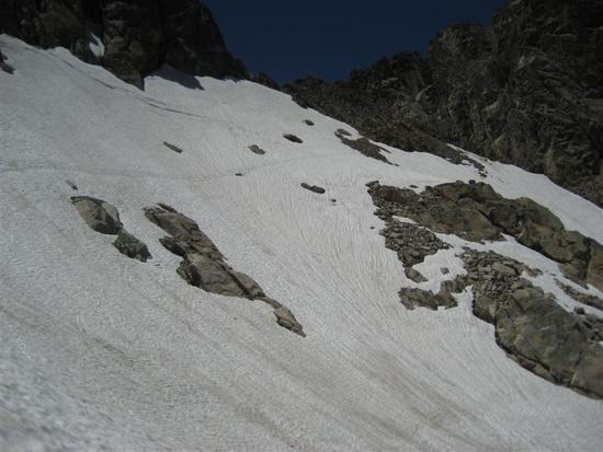
Mar 29, 2011 at 6:12 am #1716495Thanks for the info Stuart.
Do happen to know which pass that photo is of?Mar 29, 2011 at 7:39 am #1716524If you place your cursor over the photo, you should see 'Port du Lavedan'
Mar 31, 2011 at 10:37 am #1717780I've been 4 days in the Aspe (canfranc, Spain 2645m) zone, and there was almost no snow, on the next weeks I'll be going to several places, so I will keep you informed.
About the alcohol, it comes in 250ml, 500ml or 1L bottles and it soots a bit, but the meth you can find is usually really bad for stoves, I never use it.
Mar 31, 2011 at 11:56 am #1717824is anyone else bringing a canister stove?
May 1, 2011 at 5:02 pm #1731727Do you ever take a GPS when you hike in the Pyrenees? Would you recommend one for the HRP
May 10, 2011 at 6:04 am #1734921Hi guys,
My plan is to start the HRP on July 1st from Hendaye, with a 23 day schedule.
http://hrp2011.blogspot.com/I'm hoping to get my pack weight down to just under 10kg, and won't be carrying a stove this time. But I'll definitely take my Camp Corsa iceaxe, and probably Kahtoola Microspikes.
Chris
May 10, 2011 at 9:32 am #1734987Chris, I'll see you in mid-July then. By the way, what is the source of the Google map with the HRP route on your blog page?
May 10, 2011 at 3:51 pm #1735121In Europe I use a MSR Superfly as it takes both the screw on and Gaz pop fit canisters. This seems to be important as you are crossing from France to Spain and back. I found on the GR5 (full North Sea to Med trip) a few years ago that you could usually get one or the other canister type but rarely both in the same place.
I have modded the Superfly by removing the MSR burner head which is huge and unwieldy for packing due to the design of the pot supports. I replaced it with a Monatauk Gnat burner head. The threads are compatible. The Superfly is 132g but with the Gnat burner this reduces to 85g. I add a foil windscreen to complete the setup.
May 11, 2011 at 12:48 am #1735269Rick, I'll probably see you around halfway if you're hiking East to West. Happy to exchange cell no. if you want to liaise a meeting point. The Google maps on my blog were drawn by hand using the 1:50,000 French Rando maps. I'm guessing I'll need to chop down the 10 maps needed for the HRP, since it'll be too bulky to take the full maps.
-
AuthorPosts
- You must be logged in to reply to this topic.
Forum Posting
A Membership is required to post in the forums. Login or become a member to post in the member forums!
Our Community Posts are Moderated
Backpacking Light community posts are moderated and here to foster helpful and positive discussions about lightweight backpacking. Please be mindful of our values and boundaries and review our Community Guidelines prior to posting.
Get the Newsletter
Gear Research & Discovery Tools
- Browse our curated Gear Shop
- See the latest Gear Deals and Sales
- Our Recommendations
- Search for Gear on Sale with the Gear Finder
- Used Gear Swap
- Member Gear Reviews and BPL Gear Review Articles
- Browse by Gear Type or Brand.
