Topic
Gila Wilderness Group Trip- Memorial Day (3-4 days)
Forum Posting
A Membership is required to post in the forums. Login or become a member to post in the member forums!
Home › Forums › Campfire › Hiking Partners / Group Trips › Gila Wilderness Group Trip- Memorial Day (3-4 days)
- This topic is empty.
-
AuthorPosts
-
Mar 6, 2011 at 4:44 pm #1270137
Just putting this BPL PSA out there to anyone who may be in the southern NM area or is perhaps looking for a Memorial Day destination to get their feet dirty, jump start their tan, and shake the dust off their tarps.
Heading out into the Gila Wilderness for an estimated 3-4 days depending on the feedback and input from the individuals wishing to join. Trip details haven't been established yet but we're looking to hit a few key areas of the Gila Wilderness in a loop fashion, possibilities for fishing, hot-springs, bagging a peak in the Mogollon Range, and beautiful canyon hiking along the forks of the Gila River are all highlights to sweeten the deal in arguably the best season of the Gila. Only goals of the trip are to get to know some new faces in a unique environment, edify one another and perhaps share acquired UL techniques, and challenge ourselves as a group.
Trip Mileage: appx. 40-60 miles (15-20 per day)… of course this could very well change, the trip will mostly be on trail, will be challenging, but rewarding.
Possible Dates: May 27-30 or May 30-2… leaning towards the latter
So far there are 2 other individuals from BPL joining us, let's get some more!
If interested or have questions shoot me a PM or email: imeugeneius @ hotmail dot com
*I'm not serving as a guide since I'm not a guide, this is a mutual trip where feedback on all details of the trip are welcome and encouraged.
Mar 6, 2011 at 4:48 pm #1705219Eugene- if there is any way I can make it, I will. I had a blast last trip. The way things are going here, it's going to be August before we can get into the mountains :(
Mike
Mar 15, 2011 at 6:11 pm #1709437I will look into attending over the actual Memorial Day weekend – flying back from the Pacific/West Coast on evening of May 27th and starting work again June 2. I was thinking about soloing at my usual Pecos trip near Santa Fe that weekend, but Gila can work too.
ADD:
Email sent
Mar 16, 2011 at 11:41 am #1709761I'll definitely be watching this thread. I've already got a Gila trip planned for the end of the month, but I'm game for another. I'd also love to do the Skyline Trail in the Pecos.
Skyline Trail – http://www.mappingsupport.com/p/gmap4.php?q=http://dl.dropbox.com/u/1458/maps/NM/SkylineTrail.gpx
Mar 17, 2011 at 5:50 pm #1710465Bump.
Apr 10, 2011 at 3:49 pm #1722863Route Suggestion #1- Whitewater Creek-Mogollon Range (47-50 miles), 15,000ft. elevation gain/loss
Here's a link to the proposed route at TOPO! Explorer:
Whitewater-Mogollon Range loop- Gila Wilderness
For those going, emails have been sent, let me know what you guys think, your feedback, criticisms, suggestions, ideas, brainstorms, etc. will be most appreciated.
Apr 10, 2011 at 4:15 pm #1722889Eugene- looks like a great route! :(
Mike
Apr 22, 2011 at 1:38 pm #1728090I'm mostly contacting those who've expressed interest in going via email…. here's a bump for this thread if anyone is still interested in going on the trip.
So far confirmed or "mostly" sure they're going:
Larry Dyer (BPL)
Landon Schrock (BPL)
Eric Wheeler (BPL)
Justin McMinn. (BPL) …"95% sure I'll be able to make it" *email replied
Myself (BPL)
Marty Miera
Mike Moore (in spirit)*Update- currently the Gila is under a Stage 1 Fire Restriction, here's the latest, so far no park closures, but they're wisely restricting fire use due to carelessness of individuals:
Yellow Fire Update – Wednesday, April 20, 2011 @ 1:00 p.m.
Release Date: Apr 20, 2011
Contact(s): Wilderness Ranger District 575-536-2250
Yellow Fire Update – Wednesday, April 20, 2011 @ 1:00 p.m.
Wilderness Ranger District (575) 536-2250
Yellow Fire: Detected4/18/2011 in the Gila Wilderness,and located 7 miles northwest of the Gila Cliff Dwellings National Monument. The fire is approximately 115 acres in size with zero percent containment.
Resources assigned: 49 firefighting personnel are currently working to suppress the Yellow Fire at this time including 2 hotshot crews. 2 Helicopters are also being utilized for supplies and reconnaissance flights.
Fire behavior: The Yellow Fire continues to creep and smolder in grass and timber litter and is burning at a low intensity on both sides of the Middle fork of the Gila River and still with the most potential to burn to the south.
Cause of the fire is human and is under investigation.
Fire and Smoking Restrictions:
The Gila National Forest is currently at Stage 1 Fire Restrictions.
Stage 1 Restrictions:
Building, maintaining, attending or using a fire, campfire, charcoal, coal, or wood stove, except within a developed recreation site, or improved site.
The use of petroleum-fueled stoves, lanterns or heating devices providing such devices meet the fire underwriter's specifications for safety is allowed.
Persons using Forest Service designated campgrounds and/or picnic areas may have a campfire within a pre-constructed Forest Service fireplace of fire ring.
Smoking, except within an enclosed vehicle or building, a developed recreation site, or while stopped in an area at least three feet in diameter that is barren or cleared of all flammable material
For more information about current fire activity on the Gila National Forest, contact the public information officer at 575-533-6231 (Reserve) or (575) 536-2250 (Mimbres) or visit the website at http://fs.usda.gov/gila.
May 2, 2011 at 6:49 pm #1732234Here's another plot of the route that is easier to navigate. Switch the upper right hand menu from "Terrain" to "MyTopo" for a better map. I marked a few points of interest that where on my Garmin topo maps. I'll try to add a few more mile markers when I get more time.
May 2, 2011 at 7:08 pm #1732241Excellent Justin! Thanks for that, indeed, much easier to navigate than the TOPO Explorer route I slapped together.
May 2, 2011 at 9:58 pm #1732306I'd love to, but I'm not sure I'm in good enough shape to hang with you young guys.
May 12, 2011 at 8:18 am #1735736Gila under stage 2 fire restriction, fyi.
May 26, 2011 at 1:14 am #1741285I would love to do somthing in the southwest with you but It would have to be in june. I do believe nm is pretty much on shutdown because of fire but let me know if your intrested in making somthing else happen.~Kostas Lazanas
Jun 5, 2011 at 6:56 am #1745105Eugene- were you guys able to pull this trip off?
Mike
Jun 5, 2011 at 8:26 am #1745131Mike,
We were pushed out of the Gila, strict Stage 2 fire restrictions at the time of the trip meant 5 days of cold food.
A small group of us went north to the Pecos for some great spring conditions up high, which turned out to be an amazing alternative.
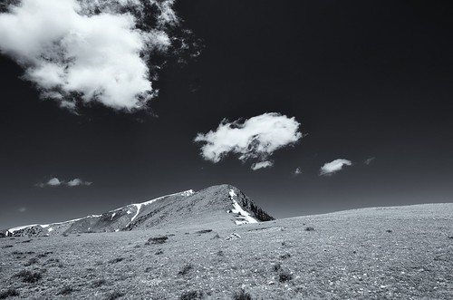
Here's one photograph I took from this past week, more to come in an article at some point.

Trailriders Wall, Pecos Wilderness, NM, 5/31/11
Jun 5, 2011 at 8:34 am #1745134Great! :) looking forward to reading about it, too bad about the Gila- hopefully the rain will come (we could have sent you a bunch!)
-
AuthorPosts
- You must be logged in to reply to this topic.
Forum Posting
A Membership is required to post in the forums. Login or become a member to post in the member forums!
Our Community Posts are Moderated
Backpacking Light community posts are moderated and here to foster helpful and positive discussions about lightweight backpacking. Please be mindful of our values and boundaries and review our Community Guidelines prior to posting.
Get the Newsletter
Gear Research & Discovery Tools
- Browse our curated Gear Shop
- See the latest Gear Deals and Sales
- Our Recommendations
- Search for Gear on Sale with the Gear Finder
- Used Gear Swap
- Member Gear Reviews and BPL Gear Review Articles
- Browse by Gear Type or Brand.
