Topic
Help from the North Carolina contingent
Forum Posting
A Membership is required to post in the forums. Login or become a member to post in the member forums!
Home › Forums › General Forums › General Lightweight Backpacking Discussion › Help from the North Carolina contingent
- This topic is empty.
-
AuthorPosts
-
Dec 29, 2010 at 10:55 am #1267059
My wife's family lives in the Raleigh area. I recently hit upon the brilliant idea of suggesting a family visit in March where my wife and daughters would spend the week with the in-laws while I explore the mountains. My wife and her family would love to have us move out there so all agreed willingly, hoping I would fall in love with the place.
So can anyone suggest a 4 day trip for late March that would showcase the best of NC? I hike solo and generally cover about 20-30 miles per day. I've been a flatlander for the last 7 years though, so will probably have to scale back on mileage to account for the elevation (figuring 60-80 miles total trip length).
I'd prefer to avoid AT traffic/shelters for this trip. I've been considering a back and forth on the Art Loeb trail, but would welcome some suggestions from those of you familiar with the area. Solitude and access to trout streams both considered a plus.
Dec 29, 2010 at 11:14 am #1678700The Art Loebe is a great trail, especially the northern section. On a clear day, you can see for miles easily spotting other landmarks. I have combined this trail with the Mountains to Sea trail and Big East Fork, both of which have decent sized streams.
I know you want to avoid AT traffic, but the Roan Highlands section is quite beautiful. You would be ahead of the thru-hike rush, but that section is frequented by overnighters, particularly Overmountain shelter. However, if we have a cooler March, it would be something to consider as it would thin out some of the weekenders.
Grayson Highlands in southwest VA is great (sometimes crowded).
And you could probably put something together doing over and through Linville Gorge while only dealing with crowds in specific spots (around Table Rock, etc).
Dec 29, 2010 at 11:44 am #1678712The Art Loeb trail is an okay trail. Personally I wouldn't want to hike it out and back just because it would get old (the same thing up and down). It's definitely a workout though.
I'd much rather do a loop, which in your case the Great Smokey Mountain National Park might be a good option just because you could put a good 60-80 mile loop together.
In my opinion some parts along the A.T. in NC are the best in the state. I like balds and there are some good ones. The Roan Highlands (section 6 I beleive) is pretty amazing. I've never hiked the whole A.T. so I'm not sure where the thru-hikers will be in late March. There are nice campsites that aren't near the shelters as well.
Dec 29, 2010 at 11:49 am #1678713Drive a little and hike the Foothills Trail in NW SC. Waterfalls, views galore, and great hiking.
Dec 29, 2010 at 12:05 pm #1678718If you want a real wilderness experience, avoid the Smokies. I love it there, it's one of my favorite places on the planet, but it's well-loved. If it were me, I would go point-to-point on the MST, maybe Craggy Gardens to Beacon Heights? Easy drop-off points on the BRP just outside Asheville, easy pickup point on the BRP near Grandfather Mountain. Lots of easy ways to bail out, but it still should avoid most of the dayhikers. This route would take you over Mt. Mitchell and the Black Mountain Crest; through the Mackay Mountain and Curtis Creek areas which see very little hiker traffic; across Linville Gorge; and through the Steels Creek and Wilson Creek drainages, both with great waterfalls. This route would be 80-100 miles, depending on entry and exit points.
Dec 30, 2010 at 6:09 pm #1679113Thanks Guys,
I will reconsider the Roan highlands given the overwhelming vote.The MST looks good, particularly around Linville Gorge and Mount Mitchell, but it appears that camping is only in public campgrounds along the Blue Ridge corridor. LNT (stealth) camping appears to be strongly discouraged- is this accurate?
I had initially picked the Art Loeb because it was described as "most strenuous" and covered a fair bit of ridgeline. This sounded good because I like a challenge and don't get to see much high country in Michigan. I may consider trying to make the North section into a loop with the East Fork and MST. (Besides, I really liked the book, Cold Mountain).
Any other suggestions would be very welcome.
Dec 31, 2010 at 2:07 pm #1679290I wouldn't rule out the Smokey mountains completely. It is the most visited park, but most people never go far. Plenty of secluded places to chose from. However it is not wilderness, so you have to plan the campsites. Brad Rogers is the resident expert on the GSMNP.
Roan Mountain is a wonderful place, but it only covers around 13 miles. It will not be very busy with AT through hikers because it is still a little early. What might be a good option is to park your car further north up the AT and start your hike at Roan Mtn. Several good shuttle services available.
Art Loeb and Shining Rock Wilderness are good options, but you would struggle to put together a big 60-80 mile loop.
The MST trail option mentioned is an interesting option, but you are correct in the camping options can be a pain.
My pick would be a big loop including Grayson Highland/AT/Mt Rogers area. I did a 40 mile loop which started at Beartree campground. Hiked to AT, then went north toward Mt Rogers. Continued on the AT through Grayson/Mt Rogers area until I reached the Iron mountain trail (old AT section). Hiked the IMT trail back to Beartree parking. I started mid morning day 1 and finish late afternoon the next day (40 miles). Later in the year, so I had more day light and some through hikers. Only saw 2 people on IMT. You could expand this option by starting in Damascus. Hike the AT north like I did and pick up the IMT. Other trails (I think feather ??) will take you all the way back into Damascus. I think that option is 60 some miles. You could always hike some side trails in the Mt Rogers area to extend your miles and find some secluded campsites.
My two cents. It's hard to go wrong with any of the options mentioned above and I hope you enjoy the trip.
Brad
Jan 1, 2011 at 6:44 pm #1679597I've hiked most of these places, and I highly recommend Scott's suggestion of the MST from Craggy Gardens to Beacon Heights. I did this section as part of a larger hike on the MST and it is supreme. You will not have to worry about avoiding the BRP camping restriction along that portion of the MST. Yes, it does have some portions on the BRP, but it would primarily be at the beginning of day 1 and the ending of your final day – you can easily time your route to avoid this problem. I would probably start at Balsam Gap though, since the area between Craggy Gardens and Balsam Gap is not overly spectacular by any means.
I did a couple of stealth camps in the BRP in a pinch with no problems since most of the trail is pretty empty. Yes, it is discouraged (possibly illegal?), but I wouldn't recommend it anyway since you are mostly on a ridgeline and finding a flat spot to camp is very difficult. Regardless, you shouldn't have to worry about this along this section.
If you are interested in doing this route, check out http://www.artshikingmaps.info for good, free, detailed maps of the route. The sections Scott suggests are 9-12.
The Wilson/Harper/Upper and Steels creek area on its own is amazing. I do a ton of dayhiking in that area and I never tire of it. Add to it Mt. Mitchell, Shortoff/Table Rock, and the Linville Gorge and its tough to beat those ~90 miles anywhere in NC. I should add that there is a fair amount of road-walking (gravel)involved in this section, but it is a bit of a relief at times since much of the rest of the trail is pretty rugged.
Jan 3, 2011 at 12:18 pm #1680141Thanks guys. I really appreciate all of the suggestions. I think I will go with the mountains to sea trail. I like the combination of ridgeline, gorge, and waterfalls- should be a good North Carolina sampler. Hopefully this works out and I get to try some of the other recommendations in the future.
I'll post a trip report to let you know how it went.
Jan 5, 2011 at 5:07 am #1680652I echo the above comments on the MST thru the Wilson Creek area in Pisgah NF, Grandfather ranger district. You could park somewhere around Hiway 181 where the MST trail crosses and go north down the Greentown trail where you'll eventually tie in with Upper Creek. SECRET: If you turn right at the creek junction(and not left where the MST follows Upper upstream), you'll follow a faint trail going downstream and soon crossing Upper to the left. On the other side and about 400 yards you'll reach a great campsite I call Burnthouse Camp. On one side of camp is Upper Creek and behind camp is a hundred foot water fall of Burnthouse Branch.
BONUS SECRET: If you follow Upper Creek downstream from this campsite you will reach a hidden gorge as good as any in the southeast. It's a rock canyon with water and cliffs.

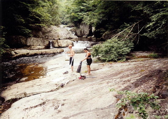
This shot shows part of the canyon in Upper Creek. The area is full of great swimholes.

Here's another shot in Pisgah.

Here's the top of the hundred foot falls I was talking about. There's a big rock ledge and the creek filters thru a million pieces of moss on a large rock face.
Jan 5, 2011 at 6:17 am #1680661Wow Walter and Craig, you guys really know my woods pretty well! Walter I thought I was the only person who knew about the area around Burnthouse Branch and Upper Creek; guess I was wrong!
Jan 6, 2011 at 8:05 am #1680981and the countless thousands of other BPL readers. It takes a truly selfless man to share his secret spots. Thank you.
Jan 6, 2011 at 8:50 am #1680996Ike let us know when you're in the area; I live in Burke County, not far from Linville Gorge and Wilson Creek. I'm up there nearly every week, so I'd love to come meet up with ya!
Jan 7, 2011 at 11:48 am #1681470Jan 7, 2011 at 1:35 pm #1681515Just thought I'd chime in with my recommendation for the Wilson Creek area as well. So many great falls and some really nice campsites throughout. Can't really go wrong. If you happen to find yourself further west, the Joyce Kilmer-Slickrock Wilderness is also amazing. That's on the border with Tennessee though so it may not be the best option if you're driving from Raleigh. NC is an amazing state to hike in. I was born and raised in Central Michigan (Mt. Pleasant) and the contrast between the two different ecosystems/terrains is great to experience. Have fun!
Jan 9, 2011 at 8:27 am #1682029Just fine tuning my gear list. What is the bug situation like in late March? Will I need to bring bug dope? Bear bagging yes or no?
Jan 13, 2011 at 4:57 pm #1683689The Smokies are awesome, and I don't think they're overused. Certain trails are, and the areas close to the roads are, but if you go back in the mountains, it feels like you're miles away.
Linville Gorge is a more rugged area. I haven't hiked there, but it's well-known as a beautiful and difficult region to backpack in. I think the difficulty is mostly with staying on-trail, but check it out!Feb 23, 2011 at 6:39 pm #1700762Brad – I've come across several of your postings and you seem to have a terrific grasp on the type of options I am pursuing for a 3-4 day trek next week. I am taking along my athletic dog (lab mix), and am considering either Art Loeb or Grayson Highlands. I can probably cover 12-15 miles / day given that I am in solid running / biking shape and occasionally do hike here in Raleigh.
I have done some overnight back country trekking, but am far from an expert.
I've researched both options extensively, and would value your insight. I originally wanted to do some loops in the Smokies, but unfortunately they don't allow does. Therefore, I'm looking for the next best thing.
Thank you very much.
Apr 3, 2011 at 9:14 am #1719274I just want to thank you all for the help with planning. I just completed my Mountains to Sea trek this week, and it was an amazing experience. A (very wordy) trip report is now posted.
-
AuthorPosts


- You must be logged in to reply to this topic.
Forum Posting
A Membership is required to post in the forums. Login or become a member to post in the member forums!
Our Community Posts are Moderated
Backpacking Light community posts are moderated and here to foster helpful and positive discussions about lightweight backpacking. Please be mindful of our values and boundaries and review our Community Guidelines prior to posting.
Get the Newsletter
Gear Research & Discovery Tools
- Browse our curated Gear Shop
- See the latest Gear Deals and Sales
- Our Recommendations
- Search for Gear on Sale with the Gear Finder
- Used Gear Swap
- Member Gear Reviews and BPL Gear Review Articles
- Browse by Gear Type or Brand.
