Topic
Gila Wilderness in the Fall
Forum Posting
A Membership is required to post in the forums. Login or become a member to post in the member forums!
Home › Forums › Campfire › Member Trip Reports › Gila Wilderness in the Fall
- This topic is empty.
-
AuthorPosts
-
Nov 8, 2010 at 4:05 pm #1265269
Here is a report for my trip to the Gila Wilderness Area. Thanks Eugene for the help planning this.
I was drawn to the Gila because it was remote and scenic and it wasn't likely to be snowed in in early November. My old stomping grounds in Colorado might have been open but they would be colder and I would have to bail out quick if it started to snow.
Day One West Fork Trailhead to Hell's Hole – 12 Miles

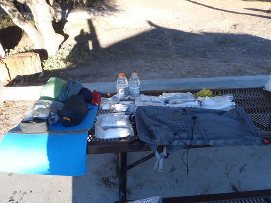
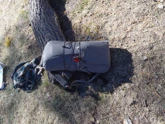
I spent the night in the Lower Scorpion Campground because it was too late to get on the trail. I woke up in the morning and used the picnic table as a place to organize my gear. I went through several gear lists for this trip. At first I was assuming Colorado like weather that would have involved possible single digits and the chance of a freak snowstorm so my gear list was pretty heavy. Eugene Smith assured me that it wouldn’t be that bad, lows in the 20s were more likely. I than swung to the other extreme and was looking at a gear list barely over 5 pounds. I ditched this list for a couple reasons. One thing I look at when I plan for a trip is how long I will be on the trail verses how long I will be in camp. For this trip I wanted to travel as far as I could during the day but I didn’t want to navigate canyons and river crossings in the dark. The fact that it was November meant I would be dealing with longer nights. I went light but not SUL. I had a rugged pack, seperate rain gear and a warm coat. My baseweight for gear was about 6.5 pounds plus food, two liters of water and a book to read. My total pack weight was an estimated 13 to 14 pounds for the three day trip.
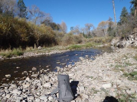
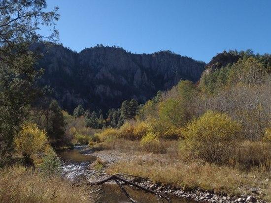
I was pleasantly surprised at how low the West Fork of the Gila River was. I’d been told New Mexico was in a drought so I didn’t expect it to be at flood stage. For the most part the river was below knee deep. The flood plain along the river was impressive though. For the water to cover some of the areas it had it must have been at least five or six feet deeper. At first I tried to keep my feet dry by crossing on rocks than realized this was hopeless. I crossed the river dozens of times throughout the day and my feet were constantly wet. For the most part it wasn’t a problem. My smartwool socks kept my feet comfortable and relatively warm and my trailrunners didn’t hold in much water.
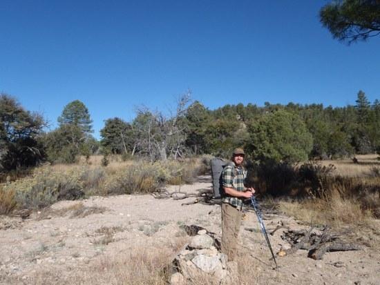
I used the sign post at the wilderness boundary to set my camera up for a self portrait. I was using my new Olympus Tough 3000 camera on this trip. After breaking four cameras I had desided to get something that was waterproof, dustproof and shockproof, even if image quality suffered a bit. Overall I was very pleased with the quality of the pictures. There are certainly better cameras out there but the Olympus was plenty adequate for my purposes.
I was surprised to find the hardwoods in their fall colors. Along the river bottoms there were a ton of oak and cottonwood trees that were turning yellow. Unfortunately I only got a couple of good pictures of the color. The sun was out and this made the stream crossings much more pleasant.

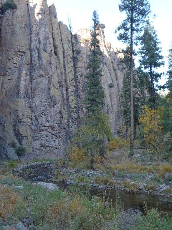
I tried to get a picture of the cave dwellings but they were hard to see with the shadow. In the large dark cave there were runs. In the smaller cave to the left by the pine tree you can barely see the remains of a wall. A ranger told me these were from the Mogallon People who apparently merged with other tribes before the arrival of the Europeans. This was also the general area where Geronimo was born so the area was some interesting history. Another historical character from the area was “Bear” Moore who killed a grizzly bear in hand to hand combat with a knife!

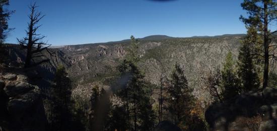
The trail climbed up onto a bluff above the river and I was able to take a couple of good panorama shots. The terrain here reminded me in some ways of the Lost Creek Wilderness in Colorado. The Lost Creek Canyon also has a lot of neat rock formations and is very rugged as well. I would not want to get lost in either place.

I like to keep track of where I am on the map but this was frustrating along the Gila because it was hard to find a clear landmark. There were lots of things to see but it was hard to distinguish one cliff from another on the map. When the trail did a couple of switchbacks and climbed up onto a knoll I was able to pinpoint where I was a bit better. Navigation was always a bit of a challenge however although the trail junctions were all well marked. After passing the knoll I thought I’d be clever and keep track of where I was by counting stream crossings. Unfortunately even the updated USGS maps where not detailed enough to make this work. In approximately five miles I crossed the Gila 26 times!
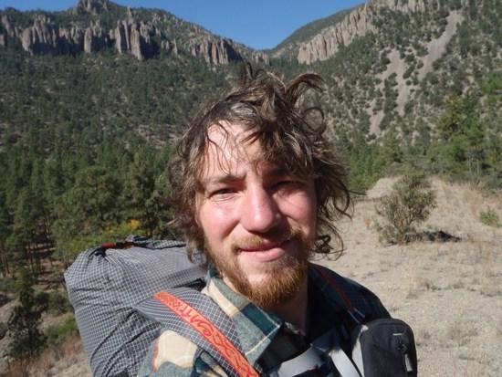
I had no idea I looked THAT bad! And it was only the first day too.
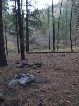
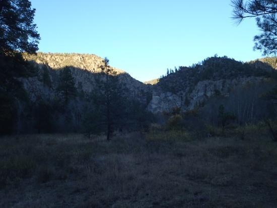
As the sun began to set the temperature began to draw and I started looking for a good campsite. I found one that would have worked but it was not particulary desirable. I wanted to keep going but I didn't want to be hiking the canyon and wading the river in the dark. As the canyon got darker it was harder to read the bottom of the river and I almost twisted an ankle. As the tension between finding a campsite before dark and reaching my destination of Hell's Hole grew I picked up the pace. Finally I saw the canyon open up a bit which was a welcome sign. I found a nice campsite next to the trail split for Hell's Hole.

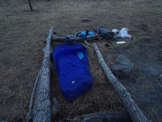
In the summer I go to bed when the sun goes down and get up at sunrise. In the fall however the nights are too long for this and I end up waking up at 2:00 AM bored. My solution is to stay up later at night. I built a fire and stayed up till around ten reading and cooking summer sausage on a stick than went to bed. I was warm enough in my Golite UL 20 quilt and down jacket but I woke up at about 4:00 AM with a sore back. I was sleeping on packed dirt and I wished I’d brought my thermarest. I felt like I could have used a bit more insulation underneath. I wasn’t sure what the R value of my cheap foam pad was but my back seemed to be the only spot that wasn't warm enough.
Day 2 Hell's Hole to the Meadows 12 to 13 miles
I began packing as soon as I realized the sun was coming up but the canyon remained in shadows for a while. I would be hiking across a dry mesa toward Woodland Park and the Rangers had warned me that a lot of the springs and ponds where dry. I drank my two liters of water and got more at the river right before heading up the trail. I had just waded across the river and the combination of wet legs and wet hands and stopping movement for a few minutes gave me quit a chill. It wasn’t’ a problem but it was a sobering moment. If I got wet out here I could be in real trouble real fast. I decided that in the featue I would pay attention to what I was doing more.
The hike up involved some steep switchbacks but fortunately it wasn’t really high elevation so I wasn’t having to worry about altitude sickness or acclimatizing. I welcomed the workout because it helped me warm up. Soon I was stopping to shed layers.Once I got onto the mesa the forest was open enough to let the sun through and I began to warm up. The forest on the mesa top was mixed but mostly Ponderosa Pines. Also known as “Yellow Pine” these trees have a faint vanilla smell. I understand that certain Native American tribes ate the inner bark and made medicine from the sap. The trail was easy going for the most part but occasionally it was overgrown with grass so I had to make sure I didn’t wonder onto a game trail.
The pond at Woodland Park still had water in it but it was nasty and I would have had to wade through mud to get too it. I still had water left so I decided to wait till I got to Prior Creek and see if there was water there. I did see a horse that had apparently strayed.
I ate lunch at Prior Cabin and tanked up on water. I don’t know the story behind this cabin but apparently it was built by the Forest Service back in the early 1900s. I understand it’s preserved for historical purposes and not really used. It was locked up so you can’t stay in it. I’m not sure I would want to anyway. I imagine it would be full of mice. The spring was just barely flowing but the water was clear except for a few bugs.
I unpacked my pack and let the quilt air out than repacked it. I’d put a lot of stuff in waterproof bags and I needed to take some of the air out to make things fit better. My new pack performed very well but it was almost too small for a trip this long with extra insulation.

Heading towards the Meadows I began to get some impressive views of the Middle Fork of the Gila River. Time permitting I was hoping to follow the Middle Fork back out. I was feeling a couple of sore spots on my feet but kept pushing on, a mistake I would later regret.
I followed the trail down to the meadows and found several very nice campsites. However it was a bit early and I was hoping to explore a bit more. I was hoping to get as close to Little Bear Canyon as possible before camping for the night. This would put me in a good spot to hike out the following day with time to get home. Unfortunately my feet were beginning to hurt and the trail was rugged with a lot of creek crossings. I went about a mile than pulled out the map. I had two problems. First I was going too slowly to get anywhere near Little Bear Canyon by dark which would mean more to do the following day when I needed some time for the drive home. Another consideration was that I didn’t feel like camping again in a narrow canyon on hard ground. I wanted a softer spot where I could get the sunlight faster in the morning. The map showed the canyon would be narrow for a long time. The brush was also thicker which meant when it got dark I would have to take what I could get for a campsite. I decided it wasn’t worth it and headed back to the meadows. On the way back I saw a sign I’d missed that said it was 8 ½ miles to Little Bear Canyon which was farther than I’d thought it would be. There was no way I would have got that far.
My campsite was nice but the ground was hard. I raked up some Ponderosa Pine nettles and piled them up between some logs. I got them about 2 or 3 inches thick than put my mat ontop. This made a much softer and warmer bed for the night.
Day 3 Meadows to West Fork Trailhead 9 miles
I woke up the next morning feeling much better thanks to the pine nettle mattress. I debated following the Middle Fork back but decided not to. I could have made it in a long day but with my schedule it would have just pushed my drive home back too far for comfort. The alternative to the Middle Fork was to cross the mesa back to the West Fork of the Gila near the trailhead. I hit the trail fast and hike till I was warm than stopped to doctor the blisters. For whatever reason these were the worst blisters I remember having, ever. This was funny because this certainly wasn't my longest or most difficulut trip. I don’t know if it was the shoes, the terrain or my wet feet. I wore sandals for a lot of the summer so I may have lost some of the calluses on my heals.
I spent most of the morning in the Ponderosa forests. The trail was gently and not overly rugged so I made good time.

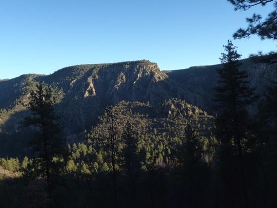
I had been afraid I was missing out on scenery by skipping the canyon hiking but I was pleasantly surprised by the views as I came to the edge of the mesa.
Once I was back in the West Fork Canyon I quickly hike the last couple of miles to the trailhead arriving by 1 PM.
I chatted briefly with a ranger who asked if I was a CDT hiker. Apparently I looked about as scruffy as one and they were basically the only ones out on the trail. I considered staying for a tour of the Gila Cliff Dwellings but I really needed to be getting home so I headed out. I did get a final picture doing the “hey mom I’m an Ultra Lighter,” pose.
Gear Thoughts
Pack
I was happy with the way my pack worked. It was just barely big enough for this trip, any more and I would have used my Jam. When it was stuffed to the brim it was less comfortable but as it emptied out it was much better. I fixed a problem from an earlier pack by making the torso longer which made it way more comfortable.
Quilt
My Golite UL 20 Quilt kept my warm down to an estimated 25 degrees. The first night I was warm enough but not toasty. The second night with my improvised mattress under me I was much more comfortable and warmer as well.
Camera
Overall I was happy with how my camera worked. It seemed that it struggled a bit more than my old Nikon in tough lighting situations (too bright or to dark). Once I got the hang of the adjustment it did a bit better. For most of my shots I couldn’t tell the difference.
Reading Material
I normally don’t bring a book but it was a nice thing on this trip. I could read by the fire until I got tired than go to bed and sleep most of the night. This was a huge improvement over past trips in winter when I would usually wake up very early in the morning and have to wait for sunrise.
Maps
Apparently there are no Nat Geo maps of the Gila. The Forest Service sells a map of the wilderness area that shows the trails but its not detailed enough in showing the terrain. They also sell USGS maps. I bought the wilderness map and two USGS maps that showed most of where I was going. I wanted the detail but I didn’t see the need to buy maps to cover the whole area. The larger map was convienant for quick checks at trail junctions and it was insurance in case I ended up was off course in an area not covered by my two USGS maps.What I’d change if I went back
If I did this trip again I would probably bring more synthetic insulation and less down just because you’re around water so much. I never really needed my raingear or my tarp although the rain suit was useful as an extra layer. I might use a poncho tarp instead and add a synthetic vest.
Overall it was an awesome trip. I was very impressed by the Gila Wilderness. The scenery was very good, it was rugged and remote and there are lots of options for loop hikes. The entire time there I saw only one person in the wilderness area. The Gila is definitely and awesome destination and I hope to get back and spend a week or so there someday.Nov 8, 2010 at 7:36 pm #1662365Luke,
I thoroughly enjoyed this report, thanks for carving out the time to assemble your experience. It's very gratifying to see someone's experience in the Gila as these are very rare here on BPL, the Forks of the Gila are prime canyon country for year round exploration as you showed. You nailed it, pinpointing your location in the Gila can be tricky, the maps aren't very accurate, and are best used for reference, but it keeps the crowds at bay.
I like the look of your pack, did you make it? Very nice pack weight for a 3-day in the Gila during fall, mind sharing a little more? I like your idea about synthetic gear use in the Gila, I've since picked up a synthetic winter jacket for that reason, my dilemma is the air is so dry there that down works so well and is ideal assuming you keep it dry, you just have to be judicious in your packing and take extra precaution crossing.
It was very interesting to read your thoughts on selecting a campsite in the canyon, as I struggle with this every time I enter the Gila, I'm always nibbling at the bone trying to find "the" campsite and it's easy to keep telling yourself "just one more bend and crossing and I'll stop…. ok… one more". Your first day leg to Hells Hole reminded me exactly of my trip last April there that had us doing one more crossing in the increasingly waning daylight, I was tired, the spring meltoff crossing was navel high, and I was intent on getting to Hells Hole with dry gear before sundown. We camped exactly where you did, pretty ideal spot. The West and Middle Fork are relentless, like you said, 26 crossings in 5 miles and eventually you just stop counting. I think we counted over 100 crossing from the headwaters of the Middle at Snow Lake to the Gila Ranger station 2 springs ago. The Gila tears shoes up, and feet, you can easily retire a pair of trailrunners there after 5 days or so of exploring. It sounds like the cold crossings, gravel, sand, dirt and pine got the best of your feet perhaps, the constant cold wet water and dry air and trail combination will work your feet raw pretty quickly.
It sounds like you made a smart decision heading out on the mesa instead of walking out the rest of the Middle on Day 3, however I think you would've been just fine hiking a few more miles down to the Little Bear Canyon junction and hiking up and out and back down to Spider. You would've been able to take a hot dip in Jordan Hot Springs. I like your idea of the Poncho tarp as a shelter, for 3 season use in the Gila it would be ideal.
Luke, I hope you make it out there again soon, hopefully next time we can connect up and do something in the upper elevations of the West Half of the Gila in the Mogollons. Shoot me a PM when and if you find yourself down here again. Awesome trip report.
Nov 8, 2010 at 7:58 pm #1662373I think I'm in agreement with you on the packing dilema Eugene. I used mostly down because it worked so well there. My only synthic insulation is a 16 oz REI jacket. Its kinda thin for 25 degree weather. In Colorado I would layer it over a 9 oz vest. Unfortunately I left that vest at my parents house in VA so for this trip I brought a 20 oz down jacket in place of the REI jacket and vest. At some point I want to get a kit and make a snythic pullover thats a bit lighter and maybe a vest to layer on top of that. Since you asked about the packing list I'll see if I can post it.
Pack (homemade) 11
Sleeping
Quilt (Golite UL 20) 16.5
Equinox Bivy 6.5
Pad 7Shelter
Tarp (homemade 1.1 Nylon)8
Stakes 3
Cord 1Clothing
Windshirt 3
coat (down) 20
Rain coat (Virga) 7.5
Rain Pants 4
Gloves 1
Socks 1
Balaclava/hat 3Kitchen
Aquamira 1
Bottles 2Misc.
light 2
Lighter 1
rope 1
First Aid 1
Camera 5
Total 105.5Yes the pack was homemade. It was based on a previous pack that was sort of based on the Jay Ham pack in "Five yards to SUL" so the design has evolved a bit. It weights about 11 oz. It was designed to be more rugged that my SUL pack but still small and light for my short trips.
I agree that I'm always "nibbling" and going one more bend.. to find that perfect campsite. I didn't mention but I also noticed a lot of wear and tear on my shoes.
Yes a poncho tarp would have been ideal considering there was almost no chance of rain.
I'll let you know if I come back out there, maybe this spring? I'll be sure and keep you posted. Shoot me a PM so I know how to get ahold of you. I would love to check out the Mogollons.Nov 8, 2010 at 11:28 pm #1662434Luke,
Really enjoying seeing your photos and the great narration about your trip.
Hope you post up more trip reports of your future trips as this one was just a pleasure to read.
Thanks for sharing your journey and taking the time to post up the photos and write your story.
Really nice to see other parts of the country through your eyes.
-Tony
Nov 19, 2010 at 6:54 pm #1666238nice report and nice homemade pack! :)
Eugene also helped me w/ my trip into the Gila (mine was a spring trip)- I chose that area for similar reasons- our backpacking doesn't really get under way until July, so the Gila was a great choice
I'm definitely going to be back, lots more to see
Nov 19, 2010 at 10:38 pm #1666283Thanks Tony, your trip reports about the Sierras have been inspiring, I'll have to check out some of your areas if I'm ever back in CA.
Mike maybe we'll cross paths there some day. I would love to do a really long trip through the Mogollans and the canyons and possibly crossing back into the Aldo Leopold Wilderness as well. Lots to see there.Dec 1, 2010 at 6:34 am #1669673Thouroughly enjoyed this trip report.
Dec 1, 2010 at 6:44 am #1669679I'm hoping to hike that area some day soon.
Jan 17, 2011 at 12:30 pm #1685123Very nice photos and trip report. I enjoyed the report about Prior cabin and that area. I'm planning a 7-9 day trip this summer that might include a trip to the cabin and the Woodland Park area. (I've done both the North and West forks of the Gila but never between them.)
I have hiked the Gila Wilderness several times, but I'm not a true ulta light backpacker yet. Climbing up the hills out of the canyons makes me want to be one; especially going up to the Crest of the Mogollons. I'm slowly shedding some weight, but I still take extra stuff "just in case" and because I usually hike solo in the wilderness.
I also lost a pair of boots along the West Fork of the Gila. The combination of the rocks and constant soaking in the river caused a blow out in the sides of both boots after two days. (OK, they were a bit old, but still they were in good shape when I started!) Since that trip I now use old running shoes down in the canyons when constantly fording the rivers and creeks.
All my hiking has been in the summer, trying to squeeze in trips between the end of May (I teach in a high school) and the onset of the monsoon season in July. Plus avoiding any major forest fires that tend to break out in late June in the forest. I didn't have to worry about the cold, but the rivers were a bit higher.
Thanks for the nice report.
Jan 19, 2011 at 11:19 am #1685897Good trip! I was a wilderness ranger there for several years. The choice of shoes is difficult. For the river, I always wore an old pair of Chuck Taylor high tops. The high tops keep the sand and gravel out of the shoes and they are fairly quick drying. But, if that is all you brought you have to be very careful on the rocks if you leave the canyon and head over the mesa like you did.
Prior Cabin does get used by the New Mexico Game and Fish when they patrol during the hunting seasons and sometimes by the Forest Service. It's nice to crawl into the cabin and not have to worry about setting up a camp. As I understand it, the building on the east side is original to early settlers and NMG&F built the one on the west sometime later. The porch was added to it in the late 1980's.
-
AuthorPosts


- You must be logged in to reply to this topic.
Forum Posting
A Membership is required to post in the forums. Login or become a member to post in the member forums!
Our Community Posts are Moderated
Backpacking Light community posts are moderated and here to foster helpful and positive discussions about lightweight backpacking. Please be mindful of our values and boundaries and review our Community Guidelines prior to posting.
Get the Newsletter
Gear Research & Discovery Tools
- Browse our curated Gear Shop
- See the latest Gear Deals and Sales
- Our Recommendations
- Search for Gear on Sale with the Gear Finder
- Used Gear Swap
- Member Gear Reviews and BPL Gear Review Articles
- Browse by Gear Type or Brand.
