Topic
Lost Coast
Forum Posting
A Membership is required to post in the forums. Login or become a member to post in the member forums!
Home › Forums › General Forums › General Lightweight Backpacking Discussion › Lost Coast
- This topic is empty.
-
AuthorPosts
-
Jun 14, 2010 at 7:00 pm #1260158
Howdy all,
I have some general questions about the Lost Coast I was looking for guidance on…
I've read a few trip reports, but all the starting and ending locations seem to vary.So:
-What is the "official" start and end of the Lost Coast hike? I typically see Mattole as the start and Black Sand as the finish, for a total of ~25 miles one way. Is this the typical "thru" hike of the Lost Coast? What is the complete hike?-Would I likely be in for crazy rain if I went out on July 1st?
-Is this trip open to surf fishing?
I'm considering a yo-yo to spare myself a car shuttle and simply be out a little longer.
Any tips on doing this trip (I'm aware of high-tide issues)?
Thanks.
Jun 14, 2010 at 9:37 pm #1620137The Lost Coast is divided into the King Range National Conservation Area, on the north end, and the Sinkyone Wilderness State Park, on the south end. King Range portion is mostly Beach and Sinkyone section is in the woods, on the ridge above the ocean.
Mattole River is the northerly end of the King Range Portion of the Lost Coast. Shelter Cove is the end of the beach trail at the southerly end of the "beach" portion. The King Range NCA actually extends about seven miles south of Shelter Cove to near Point No Pass.
July should have mostly good weather. Maybe some fog. Always check the weather before you go. The Lost Coast is no place to be caught in bad weather.
You'll need a bear canister. There are bears at Big and Miller Flats. Raccoons are a problem also.
Go and have a good time. Do pay attention to the tides. I've gotten stuck and had to wait for five hours.

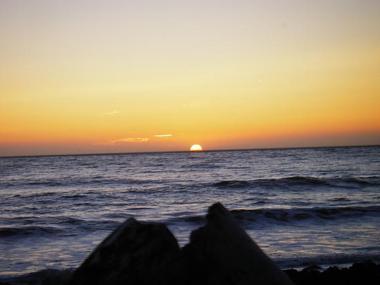
Sunset at Cooskie Creek.
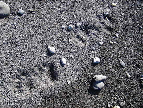
Bear Tracks south of Shipman CreekJun 14, 2010 at 9:52 pm #1620144Saltwater fishing is OK. Freshwater creeks are off limits. Some areas of the Mattole River are also open to fishing. Weather should be good in July. Last few here have been not rainy at all. Can be hot.
Jun 14, 2010 at 10:03 pm #1620148I did a few nights on the Lost Coast a couple of years ago in Feb, specifically the Kings Range Area and loved it. Snuck in between storms and had great weather with very few people.
Next time I go up to that area, I'll be going to the Sinkyone Wilderness area because there is no canister requirement.
From the BLM web site about Sinkyone: "Food Storage: Bear canisters are NOT required in the Sinkyone Wilderness State Park but take proper precautions when storing food. All scented items (food, lotions, toothpaste, hygiene products, trash, etc.) should be stored away from your campsite, NOT in your tent."
Jun 15, 2010 at 7:39 am #1620219Thanks for the info everyone, I appreciate it.
Forgive my ignorance, nobody around here stocks maps for the Lost Coast, I have one in the mail…
Thoughts so far:
A. Starting south of Shelter Cove (Point No Pass?), going up to the Mattole River and then heading back the same way. It sounds like that would put my total mileage at a bit over 60 round trip.
B. Starting further south in the Sinkyone and going to the Mattole and back? Don't know what this trip would entail mileage-wise as I'm map-less right now…Any better trip ideas incorporating the Lost Coast?
Here's my situation:
*7-8 days to spend in the area. I have about 10-11 days but am including drive times and a layover in Sausalito with a friend.
*I don't mind doing a yo-yo if it saves me the money and the hassle of figuring out a shuttle. I think I'd prefer car to car.
*I enjoy 25+ mile days in the Sierra with big elevation, etc…I know the going on the Lost Coast can be slow because of tides and sand/rocks, but suffice to say I'm confident I can log mileage at the higher end of the curve. Thus I think a long yo-yo or loop of some sort is reasonable.Again, thoughts are greatly appreciated.
Jun 15, 2010 at 8:42 pm #1620468Utilizing the inland trails can really kick up the mileage and effort. Once you get your map(from the BLM?) you will see the possibilities. I could assist with a shuttle if you so desire. I have not yet done the Sinkyone section, but I'm sure some here have. I think that section is a little over 21 miles.
Jun 15, 2010 at 9:11 pm #1620482Thanks for the offer Ken, it's very generous of you.
I get my map tomorrow so I'll be able to make more sense of this. Since I have the time, now I'm considering yo-yo'ing the whole thing, including Sinkyone. Sounds like it would put the total miles, round trip, at ~95…that's very mellow mileage for 7-8 days. I figure if I'm driving 10+ hours to get there, I might as well do more than the 25 mile northern section.
I might PM you some specific questions if you don't mind.
Thanks again.Has anyone here done the Sinkyone section?
Jun 15, 2010 at 9:29 pm #1620487Craig. Glad to help in anyway I can. PM away!
Jun 15, 2010 at 10:50 pm #1620499I have hiked both the King Range and the Sinkyone portion of the Lost Coast. With the amount of time you have it will be easy to walk both the Kings Range and Sinkyone. I used to live near there and have extensive knowledge of the trails, shoot me an email if you have any questions. The Sinkyone is an amazing walk that includes giant redwoods and plenty of wildlife. The Roosevelt elk herd (usually near Needle Rock) is particularly awesome!
Jun 16, 2010 at 8:10 am #1620563Well gosh darn, now I'm getting excited!
A day or two in the giant redwoods followed by a few days of fishing the beaches – and then reverse- sounds like just what I need right about now.
Thanks guys.
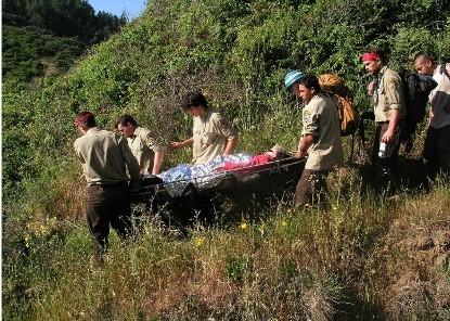
Jun 16, 2010 at 12:33 pm #1620630Here is a pic of the Sinkyone views just watch for tics.
The trip started great.
But ended bad
 Jun 21, 2010 at 6:12 pm #1622126
I'm finalizing my Lost Coast plans as we speak. Looking to do a leisurely trip with plenty of time for surf fishing and hanging around on beaches…So far the general idea is as follows:
Day 1 (July 2): Begin at Usal Camp at southern end of the Sinkyone Wilderness. Spend night one somewhere in last 3/4 of Sinkyone.
Day 2: Sleep somewhere passed Shelter Cove
Day 3: Stay somewhere in the Spanish Flat vicinity
Day 4: Reach the Mattole, stay in that area.
Day 5 – ?: Head back to the car and sleep at any of the cool spots I missed on the way up. I'll likely be moving faster at this point.I was hoping I could confirm the following with anyone that's done the northern section:
1. According to the info I have, the spots impassable at high tide are:
-Punta Gorda
-Sea Lion Gulch to Randall Creek
-South end of Miller Flat to north of Gitchell CreekIs this right?
2. Any recommendations on websites to find tide tables/time conversions for the area? All the links I've been given are dead. I'm assuming everything is based off of Shelter Cove?
Any other tips appreciated.
Thanks all.
Jun 21, 2010 at 6:19 pm #1622130Jim post pics like that, and you need to tell the tale
Jun 21, 2010 at 7:15 pm #1622163PM me your address and I will pop a tide book with the corrections in the mail to you. Did you get your map? The one from the BLM is very good and the packet( $5)they provide normally comes with some extra info and a tide book.
http://www.blm.gov/ca/st/en/fo/arcata/kingrange/krnca_maps.html
Some additional information here as well.
Jun 21, 2010 at 7:33 pm #1622169You're cool Ken, Thanks.
Jun 21, 2010 at 8:47 pm #1622205Ken, To make a long story short we were heading back to base camp and crossing a log over a gulch my wife sliped and fell about 8 feet and shattered her ankle. 8 screws and a plate kinda put it back together. We were lucky that a Backcountry Trails CCC Crew came along. She is still hiking (slowly).
Jun 21, 2010 at 10:24 pm #1622248Craig,
Make sure your sun hat has a stiff brim. The predominant winds are from the North/North West so you will have a head wind while traveling north. This can be a pain if your not ready for it. Sunglasses and a hat with a stiff brim are recommended.
Jun 22, 2010 at 9:57 am #1622360Craig, knowing that you like big climbs, I'd highly recommend a detour up into the King Range, including a summit of King's Peak. It's steep, but not inordinately so, and the view you get of the coast is stellar. Provides nice variety.
Oct 13, 2010 at 11:18 am #1654162I'm not sure if this is the best place to put this, but my friends and I are going backpacking in Lost Coast next weekend (Oct 22/23/24) and we want to try and avoid bringing two cars since there's only 3 of us (which means one person will be driving 5+ hours alone).
I know about the official Lost Coast shuttles and we are considering that as our backup plan, but does anyone know of a cheaper shuttle option?
Also, regarding bear canisters, I read that there are some at the NCA Rangers Station. Are those for purchasing or renting or borrowing? If we rent/borrow them, do we have to return them at that station or is there some place to return them at the trail end? Should we depend on that or should we just bring our own bear canister?
Any help will be greatly appreciated! Thanks so much!
Oct 13, 2010 at 11:36 am #1654169If you find out more about the shuttle clue us in. I'm looking at going out the next weekend after you are. It's a longer drive for me but it's been on my list of trails since I saw an early Backpacker article about it.
Oct 13, 2010 at 11:54 am #1654185Have you contacted the BLM office in Whitethorn, CA? They're the permiting station for your hike. They'll answer your canister questions.
Did you try to contact Rosanne Beijan about shuttle services? Unless you take two cars and do you're own shuttle, you should support the local shuttle services. Rosanne is the best that I've used for my Lost Coast trips.
Good Luck! And pay attention to the tide tables. You did download those, didn't you? And check the weather for the Lost Coast at the time of your trip. It's potentially life threatening to meet up with a southerly storm, on the Lost Coast. Mother Nature bats last.
Have a great trip.
Whales off Spanish Creek, Lost Coast – September 2007 -
AuthorPosts


- You must be logged in to reply to this topic.
Forum Posting
A Membership is required to post in the forums. Login or become a member to post in the member forums!
Our Community Posts are Moderated
Backpacking Light community posts are moderated and here to foster helpful and positive discussions about lightweight backpacking. Please be mindful of our values and boundaries and review our Community Guidelines prior to posting.
Get the Newsletter
Gear Research & Discovery Tools
- Browse our curated Gear Shop
- See the latest Gear Deals and Sales
- Our Recommendations
- Search for Gear on Sale with the Gear Finder
- Used Gear Swap
- Member Gear Reviews and BPL Gear Review Articles
- Browse by Gear Type or Brand.
