Topic
WInter multi-day trip Mt. Rogers
Forum Posting
A Membership is required to post in the forums. Login or become a member to post in the member forums!
Home › Forums › Gear Forums › Gear Lists › WInter multi-day trip Mt. Rogers
- This topic is empty.
-
AuthorPosts
-
Dec 20, 2009 at 12:24 pm #1253353
A friend and I plan on hiking 17 miles through the Mt. Rogers/Grayson Highlands area the 29-31st.
We will do about 5 mi the first day, so only dinner that day, second day 10 miles, third day only 2 miles out so only breakfast. So really it's just two days of food.
Elevation is 4500-5500 the whole way.
Temps I am planning on at this point are based on this week…single digits at night and twenties during the day…but if the forecast improves, it might end up being around 15-20 at night and thirties during the day.
If the weather ends up improving by next week, I may be able to take my 20 degree bag (Golite Adrenaline) and save a pound.
Think I'll be warm enough around camp with baselayers, 300 weight mitts over thin liners, Dome Perignon, neck gaiter/balaclava, Down Inner Pants under convertible pants, WM Flight, and MicroPuff? The Micropuff is sized to layer over the Flight.
Critiques welcome!
Dec 20, 2009 at 1:11 pm #1555659I think that list looks pretty good. It’s not the lightest, but you aren’t doing many miles anyways, and as I am sure you well know the weather can get nasty up there this time of year. I have a friend that lives at the foot of the mountain and I know they had about three feet of snow the other day. It will be cold and windy.
My thoughts are:
For your hiking layers, be sure you don’t overheat in that. I would have to replace that hat with a more breathable fleece hat like the MH Micro Dome for hiking and I would probably just wear one baselayer top and windshirt instead of two. I would probably forgo the base layer pants too as I am fine even in the 20’s with just my Sierra Convertables while moving. I might need more than liner gloves at those temps though. I generally go up to 200wt fleece gloves when it is that cold, but I tend to have cold hands anyways so take that for what it is worth.
With your camp clothes, I might just take the Flight Jacket and not the Micro Puff as well. You can always get in your sleeping bag if you get too cold. I also prefer 300wt mittens to gloves, they just keep my hands warmer. You could probably ditch the Buff since you already have the Balaclava. I too have been experimenting with produce bags as vapor barriers and so far they seem to work reasonably well.
Are you doing the AT – Pine Mountain Trail loop?
Dec 20, 2009 at 1:45 pm #1555677Thanks…good stuff…I changed the hiking hat to my lighter weight one because you are right…it does get a little hot with the MH hat on while hiking. And I'll just keep the wool buff but ditch the R1 Balaclava since they are redundant and the buff is a bit more versatile.
So far I've seemed to do okay hiking in the twenties with this baselayer setup, but I'll have to see how it goes this time.
I kind of like being able to stay out of my bag as long as possible on winter nights since the nights are so long…hence the two insulating layers. The Flight by itself only seems to keep me warm to 25-30 degrees when stationary. I'll give that some thought.
I have really liked the produce bag idea…it works well to roll into camp, change into dry socks with the liners over them, and then put the wet boots back on; much more comfortable around camp.
We're doing Elk Garden to Fox Creek on the AT.
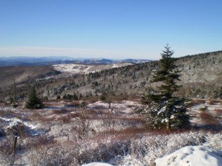
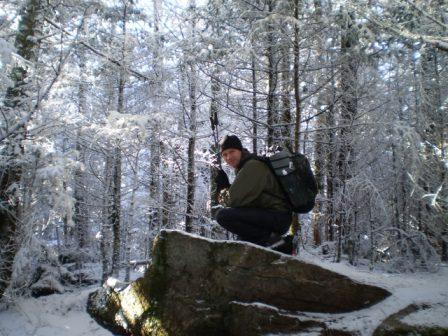
Dec 20, 2009 at 7:05 pm #1555755Jonathon, I'd say you are good to go with your list. I did an overnighter to Mount Rogers on Nov 30/Dec 1. I'll be honest the weather caught me a bit off guard, but me and my buddy were fine. My base weight was 6.5 lbs of nearly all MYOG gear.
The weather started as heavy rain leaving from Greyson Highlands right at 40 degrees, but the time we reached 5000 feet it was all snow, whiteout, and 50 mph gusts. We did decide to go for a trail shelter instead of our lightweight tents (MYOG tent weighs < 13 oz). This was the first time I have ever slept in a shelter. Through the night I'd say that shelter was hit by 70mph gusts and the temp dipped to 15 degrees.
Sleeping was a bit tough. I was using a torso length 3/8" thinlight pad and my 21 oz MYOG quilt. My friend used a Marmot Hydrogen 30 and ridge rest pad. We slept on the cold side but were ok.
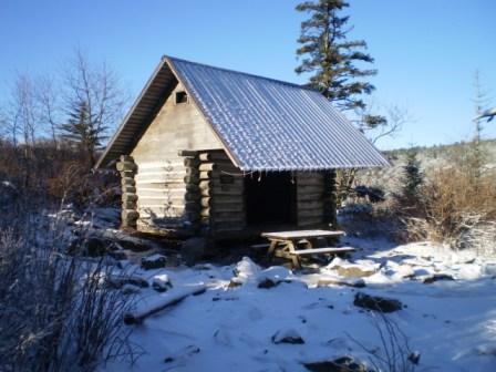
Here are a few pics of the Thomas Knob shelter.

Here is the main items in my gear (most everything > 1.5 oz)…
Packed:
* MYOG Ray Jardine Pack (9.3 oz)
* MYOG tent (13 oz) didnt use
* MYOG quilt (21 oz)
* MYOG thru-hiker Kinsman Pull over (8.5 oz) and Mimimus Vest (5.3 oz)
* 3/8" Thinlight pad torso length (3.5 oz) – I wish I had taken more pad
* Heiny Pot and V8 can stove (1.5 oz for both)
* GPS (5.35 oz)
* cell phone (2.35 oz)
* camera (4.35 oz)Worn:
* BPL merino LS top
* BPL merino shorts
* REI Sahara Pants
* Golite Reed Pants (worn entire time, but did not merino on legs)
* OR Zealot (worn entire time)
* Fleece Cap
* Fleece Gloves
* Smartwool PHD low hiking socks
* Montrail Masochist ShoesJamie
Dec 20, 2009 at 9:13 pm #1555784Your list looks pretty good, but you might consider insulated gloves with the liner gloves rather than just the fleece.
A word of warning – use caution with where you park and what you leave in your vehicle. That area has been known for a lot of break-ins at trailhead.
Dec 21, 2009 at 5:47 am #1555817I've heard warnings about parking long term at Elk Garden Junction. Vandalism is high, including a theft of a vehicle.
Dec 21, 2009 at 5:52 am #1555818Well, that's a shame…not really any other good place to park in the area from what I've seen…I guess I'll just take all valuables out and hope for the best.
Dec 21, 2009 at 6:10 am #1555819I always park at Massie Gap.You have to pass a Ranger kiosk so it is 100% safe.From there the hike to the AT is maybe 1/4 mile.Lots of good loop hikes.From Elk GARDEN,Go up hwy 58 north to the Greyson Highlands State Park.Have fun!
Dec 21, 2009 at 7:51 am #1555831I can vouch from Massie Gap and have parked there numerous times without indecent, you should also have safe parking in Damascus and at the Mt. Rogers Visitors Center on VA16. There is a small lot at VA603 but I don't know about the safety of it. The parking lot at Elk Garden is a big nice lot, I haven't heard of any break-ins but I am not surprised there have been some, it is way off by itself. I hate a thief!
Dec 21, 2009 at 11:00 am #1555903I would not recommend leaving your car at VA 603. I know of a few people who have had their car stolen or broken into a that lot
Dec 21, 2009 at 11:47 am #1555913Well, I called Mount Rogers Outfitters to see about a shuttle from Fox Creek and they told me that they haven't had any problems there or at Elk Garden in quite some time. In fact, they said a couple of their staff have been regularly leaving cars there almost every week in the last few months without incident.
They seemed to think it was no big deal.
Still trying to decide…
Dec 21, 2009 at 2:34 pm #1555967Jonathon, The area did have a history of break-ins a while back, I can not speak of the current. It is likely that law enforcement has put forth an effort to correct that matter. I can not imagine that the Damascus area wants to me know for crime against hikers.
I will tell you that the Massie Gap area feels like the safest place I have ever left my truck. You do have to pay $2/day (weekdays) and $3/day weekends so make sure to bring some cash so you can self register if the ranger station is not open.
If you want a loop that is close to 20 miles that leaves from massie gap just let me know. Also Massie Gap will garauntee that you see the ponies.
Jamie
Dec 21, 2009 at 5:18 pm #1555994Jonathon,
I agree with the rest on not leaving a car at Elk Garden. I hike this area a lot and you have plenty of good options.
– If you are set on the trip you outlined then use the shuttle service.
– I typically park at Massie Gap and have done a lot of loops. I have never had any issues.
– I have also parked at Beartree Lake in the fisherman's parking lot without any issue. It's a quick hike to the AT or Iron Mtn trail. Makes for a excellent long loop. You can also do a point to point and choose from many shuttle pickup locations (whitetop, elk garden, massie gap, fox creek, etc).Massie's Gap allows you to start at a higher altitude whereas Beartree is a low elevation start. If the snow is bad and the access roads are closed you can start your hike low where parking and roads are better.
Your hike looks to be around 17 miles, so you could easily put together a loop from Massie's Gap at that distance. The crowds are gone so you would have the area to yourself. Their are great campsites around the AT at Rhododendron gap, Bearpen Trail, Scales Trail, Stone Mountain on AT, etc.
You can also park at Massie's Gap after dark and do a night hike over Wilburn Ridge without any issue.
As the others have said check the weather often because it changes fast. I had a trip planned to this area last weekend. On Wed it looked like light snow and cold temps. By Thursday afternoon they were calling for 2 feet of snow and extreme cold. Be prepared to have a great time or maybe postpone your trip.
Probably more than you wanted.
Dec 22, 2009 at 4:58 am #1556121Thanks for the good info. I am certainly reconsidering the route and may start from Massie Gap just to make things easier.
I am following the weather closely…at this point it looks like we may be snowed on a bit while we're up there, which is great! I am glad I wasn't around this last weekend though; I'm sure it was beautiful to watch all of the snow fall but you really couldn't have gotten anywhere and it was bitter cold.
Dec 23, 2009 at 11:29 am #1556454I will add one more option that you may or may not be interested in. What about Roan Highlands on the AT? You could park securely at Mountain Harbor Hostel and have them shuttle you to Carvers Gap (13 miles) or Hughes Gap (18 miles) and walk back. I think the area is as pretty as or prettier than the Mt. Rogers area.
Dec 23, 2009 at 11:57 am #1556459Good call, I just hiked the Carver's Gap to 19E section three weeks ago with this same hiking partner and neither of us has been to Mt. Rogers!
Roan Highlands is definitely one of the most beautiful places I've been.
Dec 23, 2009 at 2:32 pm #1556485Jonathan: My warnings about Elk Garden came from an April hike in 2008 and Mt. Rogers Outfitters and some other hikers were the source of info. Plus there were warning signs on the trail back a ways from the road. I parked at the main park entrance and spent three days doing a loop hike. The rhododendrons were in full bloom. What a beautiful hike. The Scales is a big field, nice for camping.
Have fun. Mt. Rogers itself has no view, but it is not a long spur off the AT.
Not too far south from the Tom…shelter (pictured above) the AT goes over a stone wall. If you head downhill off the AT from that spot you will find other nice tentsite and trails.http://outdoors.webshots.com/album/571488418DTNLCy
You might guess why I'm headed back that way next spring!
Dec 23, 2009 at 2:46 pm #1556489My only problem with The Scales is it is always full of campers and motor homes every time I am up there. There is a nice camping area near Deep Gap past Thomas Knob Shelter. I was last up there over Labor Day and Old Orchards spring was flowing nice but the springs at Wise and Thomas Knob were stagnant and not flowing. I ended up pushing 24 miles that day to get to Deep Gap for water. I imagine there should be plenty of water up there this time of year though.
Dec 23, 2009 at 4:50 pm #1556504Bradford, Funny I was up at Mount Rogers this past labor day. I wonder if we crossed paths. I spent my first night in Lewis Fork Wilderness Sunday night past where the trail heads NE from Deep Gap (camped at creek). The next day I headed North past Cherry Tree Shelter did the Rowland Creek Falls loop then AT back down past old orchard and camped where the AT hits Pine mountain trail on north side.
Jamie
PS I was able to get water at Thomas Knob on the Sunday of labor day (not flowing much though, maybe alot of people tapping it). I was also able to get water their on Dec 1 (3 weeks ago) and it was flowing fine.
Dec 23, 2009 at 8:15 pm #1556540Perhaps we did, but I was technically only in the Grayson Highlands/Mt Rogers area on Saturday. Here was my itinerary: On Friday Sept 4th I went 18.4 miles from Mt. Rogers Visitors Center on VA16 and made camp just before the climb up Iron Mountain, then on Saturday Sept 5th I went 19.6 miles from my campsite near Iron Mountain to a campsite just past Deep Gap. And on Sunday Sept 6th I went from my campsite near Deep Gap 25.8 miles to Damascus.
I could have gotten water at Wise Shelter but it looked pretty rough, (if I had wanted to backtrack a bit there was a creek not to far north), but had plenty at that point. I was going to stop and camp just past Thomas Knob Shelter but the water was pretty crummy there too and there were a group of girls up there at the shelter with a couple of very unfriendly dogs, so I moved on to Deep Gap.
Here are my pics
BTW: I'd love to meet up with some of you in the area and do a hike sometime. Going UL has definitely cut down on my hiking partners.
Dec 24, 2009 at 12:08 pm #1556712Brad, It sounds like you and I hike similar distances and styles. I too have hard time finding lightweight folks to head out for a few days. I'd definately be up for meeting some folks in the area. I have half toyed with starting a BPL Southeast Hiking Club. It seems like there are a fair number of us that Hike VA/NC/GA/TN areas.
Jamie
Dec 24, 2009 at 1:05 pm #1556732If you end up starting something like that count me in. I have posted a few trips on the trip announcements page with little interest, and have missed a few trips there myself because I like many probably don't frequent that area enough. It seems like, though there are a few of us here in the Southeast, that there are many more here out west or in the northeast.
Dec 24, 2009 at 1:17 pm #1556736There are certainly a number from the MidAtlantic, but I once (not too long ago) posted in the forum about perhaps starting a BPL MidAtlantic chapter, only got one response.
I'd be up for some trips further south. Not a lot, as the drive is quite a long one, but I'd certainly like to know about them!
Dec 26, 2009 at 7:58 pm #1557177So we would quit hijacking this thread, I created one in the General forum.
Dec 28, 2009 at 8:23 pm #1557692Looks like the lows will only be 15-18 Tues night and 25-30 Wed night so I'll be able to save a pound and go with the Golite Adrenaline 20 instead of the zero degree bag!
I can wear my MB Down Inner Pants and Micro Puff Pullover with Integral Designs Hot Socks to bed if I need to stretch it down to 5-10 degrees.
Also since there is no snow forecast, we will bring and share weight on the Seedhouse SL3 since my hiking partner's solo tent is 4 lbs on it's own so it will help him out.
-
AuthorPosts
- You must be logged in to reply to this topic.
Forum Posting
A Membership is required to post in the forums. Login or become a member to post in the member forums!
Our Community Posts are Moderated
Backpacking Light community posts are moderated and here to foster helpful and positive discussions about lightweight backpacking. Please be mindful of our values and boundaries and review our Community Guidelines prior to posting.
Get the Newsletter
Gear Research & Discovery Tools
- Browse our curated Gear Shop
- See the latest Gear Deals and Sales
- Our Recommendations
- Search for Gear on Sale with the Gear Finder
- Used Gear Swap
- Member Gear Reviews and BPL Gear Review Articles
- Browse by Gear Type or Brand.
