Topic
Catskill Traverse
Forum Posting
A Membership is required to post in the forums. Login or become a member to post in the member forums!
Home › Forums › Campfire › Hiking Partners / Group Trips › Catskill Traverse
- This topic is empty.
-
AuthorPosts
-
Dec 18, 2009 at 11:43 am #1252909
Hi all,
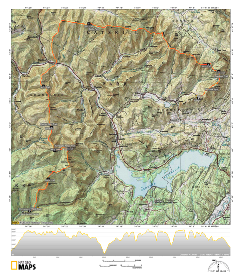
I've spent some time mapping out a hike that links the Burroughs and Devil's Path ranges of the Catskill Mountains. It's approximately 47 miles long with a ton of elevation gain (over 19,000 ft). On the Burroughs range, it's about half on and half off trail, and it's mostly on trail for the Devil's Path range. I haven't been able to find any info on someone having done this route before, which I find surprising given how much it stands out on a topographical map of the area. I'm planning on hiking it S-NE over 3 days from January 6-8. If this sounds like your kind of fun, and you have the time (I'm on winter break from school), drop me a line!

The route is a bit hard to see here, but it starts at the bottom-left and heads north then east to the upper-right.
Dec 18, 2009 at 1:08 pm #1555275Very cool, Devin. I spent a lot of time in the Catskills when I was in college, and I've been planning to get back there at some point…. someday.
I won't be able to make it this time around, but let me know how it goes. I'd love to do a bigger backpacking trip in the Catskills eventually.
Dec 18, 2009 at 7:01 pm #1555346You might find Erik Schlimmer's One Big Push on his website interesting. All 3500 foot Catskill peaks in one 6 day trip…
Dec 18, 2009 at 7:40 pm #1555354Hi Devin,
If the weather pushes you off for any reason, and you end up doing it a bit later, please let me know! I'd certainly be up for it!
Take care,
Doug
Dec 19, 2009 at 6:56 am #1555409Thanks for the link, John! I wish he had included a map of his route; I'm imagining some kind of cat's cradle criss-crossing the ranges.
Ryan, Doug: Thanks for the well-wishes. I'll be sure to post a TR, assuming all goes as planned. And, Doug, I'm actually hoping for a bit a of bad weather, but if it is put off for any reason I'll let you know.
Dec 22, 2009 at 12:01 pm #1556192Do you have a bigger map or a link? Looks like Peek, Table, Lone, Rocky, Balsam Cap, Friday, Cornell, Witt, GL, Panther, Sherill, North Dome, St. Anne's, Westkill, most of Hunter, Plateau, Sugarloaf, Twin, and Indian Head and then out past Overlook.
What is your plan?Start at Peek rd…Camp one maybe Cornell col, or just past Witt…camp two maybe Diamond Notch or so. Something like that?
Kudos for coming up with that, it's an ambitious trip that would bring you through a lot of really nice country. Are you familiar with any of the route? If not I can give you a few tips as far as bushwhack routes go. I think snow/weather conditions, and whether or not the trails are broken out are going to decide whether this is a very challenging trip or a masochists dream.
I'd encourage you to post this over at adkhighpeaks.com, you'd be sure to get some really detailed and up to date info; the people over there are super helpful and knowledgable about the area.
Good Luck.
Dec 22, 2009 at 5:44 pm #1556280Hi Kevin, unfortunately the image is big, about 6 megs, and larger than my Flickr account will allow me to retrieve after posting. If you send me a PM with your email address, I'd be glad to send the full-sized version.
As it is, it looks like you have the gist of the route. My plan is to camp somewhere on Panther the first night and somewhere on the Devil's Path the second. I have a relatively flexible schedule, so I'll also bring food for a third night if it bleeds into day four.
I've hiked in the Adirondacks, but not in the Catskills. Any info on bushwhacking routes would be greatly appreciated. I have had some trouble figuring out what snow conditions will be like this far out, but I'll be bringing snowshoes just in case. I've kept my eye on the VFFT forums for trail condition info, but I'll also give adkhighpeaks a look.
Thanks for the encouragement! I know its an ambitious route, but I'm really looking forward to it.
Dec 24, 2009 at 4:55 pm #1556767If you're planning on camping near Panther, Giant Ledge is the place. There are some nice campsites really close to the cliff. Great place to catch sunrise.
Snowshoes are very likely to be a must. Microspikes would be great. Crampons you may or may not need, but it would be wise to carry them, particularly for Sugarloaf, Twin, and Indian Head. There is a section of vertical and very steep rock on Cornell, but it can be bypassed by going into the trees.
Heading to Lone, you should leave the trail on the way up Table, @3600 feet or so and contour around to the ridge connecting them, it's really thick on the top of Table. There is a faint path.
Heading to Rocky and over to Balsam Cap is straightforward navigation-wise but the forest gets really dense so that'll be slow going.
From BC to Friday there is a fairly distinct herdpath. It may be obscured by the snow, so the idea is to drop down off the ridge to the east and follow a bench maybe 150 feet below the ridge where the forest is much more open before angling back up for Friday.
I haven't been through there, but the section along the ridge from Friday to the trail on Cornell is said to be about as thick as it gets, difficult and time consuming. If it gets too frustrating, I've heard of people descending a bit to the west toward the Neversink until the trees open up enough to permit travel without bloodletting and then regain the altitude heading up to the Slide-Cornell col.
I think the rest of the route is what you'd expect by looking at the map.
Like you mentioned, keeping an eye on trail conditions over at VFTT is a good idea, and also check out the relevant trip reports there and adkhighpeaks.
If there's anything else you're wondering about let me know.
Best of luck! Keep us posted.
Dec 27, 2009 at 5:52 pm #1557441I am free and would be very interested in doing such a trip. I have actually been trying to get out for a little while now, but my brother is lazy. My email is [email protected]. I have done about half of the devil's thumb, but it was so long ago that I only seem to remember ice. The ice was not good and I did not bring any extra traction. Fortunately, the tree limbs were abundant and I left my claw marks on many a sapling. If your still looking for a partner, howl my way.
Dec 30, 2009 at 1:27 pm #1558103*(This is a response to email received and pertaining to said emails contents. I sent return email twice, but my email is on the frits and I was not sure it was received. Please reply here on BPL if you got it. If not then I will give you my cell number on here, but I would rather give it by email if possible(more secure). The other option would be to email me your number and then I could give you my number by phone.)*
1. As far as snowshoes are concerned, I just carry a pair of homemade rigs. They are not much, just spread out the weight so I don't sink as deep. Not as good as the real thing, but they do okay where needed and don't weigh much. As far as grip on ice goes I don't plan on carrying full crampons. I have a pair of montrail vitesse to which I have added sheet metal screw studs. Their is a crack of ice that might require front points, but apparently it can be skirted around through the trees. I may or may not carry a single bpl pole for support when needed(won't need actual ice axe). This technique me saves 1-3lbs. (Note-I assume that at no point will be roping up. While sometimes advisable on steeper spots, not really necessary here.)
2. As far as dark hiking goes it would best to do so in the early morning when colder, as opposed to warming up by day only to cool down again before making camp.
3. I also think getting there the afternoon/evening of the 5th is a good idea. It would be nice to already have some elevation out of the way and to have already put ourselves in the proper state of mind to start out next day. My schedule is also flexible and while I could go through the 9th, I too would rather be done on the 8th. I am also only 3-3.5 hours from trail. Where are you from Chris? If Philly area or north jersey then maybe carpool? My map quest goes through Jersey followed by the New York State Thru Way and could pick up if possible.
4. I could definitely use copies of maps, but if not my fat ass will follow. Do you think we should each carry our own compass/map copies or will one take point?
5. As far as shelter goes I prefer to sleep alone. No offense, just a light sleeper. When weather is this cold I usually opt for a wilderness type rig(natural material shelter). They are quick to make(half hour) even in dark if you know how and are far warmer than a thin piece of nylon. I combine with a quick fire and am toasty as mice in the walls. (Note-I always carry an emergency blanket as a backup tarp, but have never yet had to use it.) Town temps are 10 low and subtract 5 for elevation(much more if windy and it has been lately). Wilderness shelters tend to stay above freezing once your body heat has warmed them up, where as a one layer tent only adds maybe 5-10 degrees. This would require a much warmer/heavier bag(0-20 degree)(2-3lb). This technique saves me 2-4lbs(shelter weight + less insulation).
6. I also plan on eating big before and after to minimize food weight. Also I have a few extra pounds that I wouldn't mind killing off(aah holiday food).
7. I highly doubt we will see much if any running water so I plan to melt all. My fire does the evening and morning melts. I usually drink a liter before start of the day then only carry one. This lasts until lunch when I use a 32oz metal bottle over esbit. Again I down one liter and carry another. Takes 15-20 minutes give or take 5 to make both and get moving again. Thats four liters over the day that lasts until making camp where fire means I can drink all I want and rehydrate. (Note- wood stoves are nice for melting water, but don't expect it to make much of a camp fire and it takes almost as long to get it burning well with wet wood as to just make a small real fire-assuming some sort of dry tinder is packed in) This technique saves up to a 1/2 pound of fuel and cook kit weight, plus 2 pounds water weight.
8. I usually bear bag, but in winter I usually sleep with since I am by a fire. In winter I worry more about the little critters who tend to steer clear of the human fire gods. (Note-bear vaults and similar are no safer than bagging-like all animals there are dumb aggressive bears and those which are "smart than the average"-human. This technique saves me a 1/2lb.
9. As far as water purification goes, boiling kills everything and even if we find running water it would be best to warm it up. Otherwise you will waste more time and energy than boiling requires due to chilling your insides.
Other questions-
1. I assume the plan is to leave a car at either end. When we meet up who is the carpool mom to other end? Two possibilities exist. 1. Two cars will initially drive to other end in which case we will all have to carpool in one vehicle back to other two. 2. We leave two cars at one end and all carpool to start in which case only one of us will have to be dropped off at his car. The third will be able to drive straight on home.
2. If something where to go wrong does your route incorporate bail out options. Not to whine and snivel, but stuff happens.
3. Communications-cell phone, radio, etc… I assume we each have something, but will we carry three or share one in case of emergency. (Note-cell phone may or may not get a signal.)
Dec 30, 2009 at 5:43 pm #1558165Hey John,
Both emails made their way to me, so I'll get back to you there.
-
AuthorPosts
- You must be logged in to reply to this topic.
Forum Posting
A Membership is required to post in the forums. Login or become a member to post in the member forums!
Our Community Posts are Moderated
Backpacking Light community posts are moderated and here to foster helpful and positive discussions about lightweight backpacking. Please be mindful of our values and boundaries and review our Community Guidelines prior to posting.
Get the Newsletter
Gear Research & Discovery Tools
- Browse our curated Gear Shop
- See the latest Gear Deals and Sales
- Our Recommendations
- Search for Gear on Sale with the Gear Finder
- Used Gear Swap
- Member Gear Reviews and BPL Gear Review Articles
- Browse by Gear Type or Brand.
