Topic
Trip this summer near Mt. Tyndall – suggestions please?
Forum Posting
A Membership is required to post in the forums. Login or become a member to post in the member forums!
Home › Forums › General Forums › General Lightweight Backpacking Discussion › Trip this summer near Mt. Tyndall – suggestions please?
- This topic is empty.
-
AuthorPosts
-
Mar 30, 2006 at 7:57 pm #1218196
I am planning my trip for aug 21 – 27 and have 3 entry points under consideration:
Onion Valley/Kearsarge Pass/Forrester Pass
Shepherd’s Pass
Army Pass
The first two get me to my primary destination the quickest – I’m heading to the upper upper Kern area
Secondarily, though, might want to explore Wrights Lakes area and/or checkout Wallace Lake
Anyone been up that way much? Would love some ideas/suggestions/reports
thanks!
Mar 31, 2006 at 8:05 am #1353891Cary,
I’m familiar with the Kearsarge and Shepherd Pass trails, Wright lakes and upper Kern.
Between the two passes I prefer Kearsarge. It has many picturesque views of lakes that the dryer Shepherd Pass lacks.
The Shepherd Pass trail offers better views of the Owens Valley and the north face of Mt Williamson is very imposing.
Wright Lakes is very near the site of the highest observed tornado in the US. One of the most frequent travelers in the Sierra was fortunate(?) enough to get pictures of it here.
I’d be glad to answer any other questions you have.
Robert
Mar 31, 2006 at 5:13 pm #1353923 AnonymousInactive
Hi Cary,
I would suggest Shepherd Pass for the following reasons: 1) It is the most direct route into the Upper Kern(about 18 miles); 2) It has very few bear problems if you can make it beyond Anvil Camp the first day and bivy either at the Pothole or at an excellent bivy site about 1/3 mile above the Pothole on the left side of the trail. Look for a small grove of stunted pines. There are several prime sites nestled among the trees. Be warned, this is a long first day, but the views are awesome and you can pretty much count on no bear problems, which is not always the case down at Anvil Camp or Mahogany Flats. Bears are also a problem at trailhead, so keep a clean car if you decide to go this way. This is the only trail on the East side that I know of where bear canisters are not mandatory. The only problems I have with Kearsarge Pass is that the whole area is crawling with bears and you will have to drop down into the Bubbs Creek drainage and then go back up to Forrester Pass (~13,400′) before dropping down to Tyndall Creek and intersecting the same trail that goes over Shepherd Pass. It is beautiful, to be sure, but much longer and would chew up quite a bit of your time which, IMHO, would be better spent in the Upper Kern, which is hands down my favorite place on the face of this planet. If you go in over Shepherd Pass, you should be in the Upper Kern by the middle of your second day, no sweat. There is a good campsite on the south side of the lake where the High Sierra trail comes up out of the Kern Canyon, but I would recommend going north to the unnamed lake with 3 bays about a mile north. Several good campsites there and it is ideally situated to be a base camp for beautiful day hikes. Another advantage of going via Shepherd Pass is that the trail goes right by past a side trail to Wright Lakes Basin. It doesn’t intersect with the main trail, but if you head for the saddle on Tawny Point, you will pick it up. It deposits you right in the middle of Wright Lakes Basin. One other thing: if you go in via Shepherd Pass, be sure to reserve your permit early as there is a 15 person daily quota and it can fill up early in July/August. Army Pass is the longest option and lots of bears enroute. Good fishing at Crabtree Lakes, though.
Best of luck.
TomMar 31, 2006 at 8:05 pm #1353928Thanks.
I’ve gone in Shepherd’s before and was kinda considering maybe an easier way in (plus the snow field seems harder – meaning scarier – to me on the way up than down)
However, I am still tempted to go that route for the reason you gave.
I’m also researching the trout eradication efforts – I don’t want to wind up at any dead lakes. Couple years ago we did a basecamp in Humphreys – I even scouted it the year before and picked it partly for it’s excellent fishing. We wound up base camped at a lake that had been gilnetted and de-fished ONE WEEK PRIOR.
Whether the eradication efforts are right or wrong, I really wish they would make a list easily available so we can steer easily away from the fishless lakes (or to them I suppose if you don’t want to see golden trout).
I’ll have a new hiking partner and don’t have his ability figured yet. I think he’ll be okay over shepherd’s though. I’ll be in better shape than last time – and last time I did it “old school,” with plenty gear and food for 9 days + (I think packs were close to 60lbs).
only other thing is I thought it’d be neat to do a different way out than in – but I guess if I go in/out same way, solves problem of figuring out the shuttle.
if this is your favorite place (mine too) maybe you’d like to come along?
Mar 31, 2006 at 8:09 pm #1353929email me if you want to talk fishing
Apr 1, 2006 at 8:54 am #1353942Cary,
An option for a big loop would be to use Harrison Pass to cross the Kings Kern Divide on one leg of the journey to Wright Lakes and Forester for the other leg. This would take you through the true Upper Kern and the basin that includes Lake South America. The only section that you would repeat would be between Kearsarge and Onion Valley.
I wouldn’t take a newbie or weak hiker to Shepherd Pass because of the 5,800 ft of elevation gain. Add in the 500 ft drop beyond the saddle that needs to be regained and you have a very strenuous workout.
I was at the Wright Lakes in October. The only lake I got near was the middle of the three most northern. It was teaming with trout at that time.
Robert
Apr 1, 2006 at 9:01 am #1353944But how much of a trail over Harrison is there? I have been wanting to go through that drainage and over to Lake S. America now for a few years. If I understand correctly the Harrison Pass is class 2-3? I will be in that vicinity Aug.21-25. Whitney Portal to Onion Valley. I would vote for Kearsarge. Sheppard is quite arduous, and that climb is killer. Kearsarge is much more moderate and quite pretty too. My two cents.
Apr 1, 2006 at 9:14 am #1353945on North side – haven’t done it but I’ve seen pictures. It is done a lot though.
We tried coming in over Millies Footpass from Lake Reflection/East Lake on year. Monsoon was upon us and by the time we got to the shoulder below the Millies Pass steep chimney, it was pouring rain (for 4 hours) with lightning striking the peaks above us – one strike sent an air blast straight down, knocking my father down.
While we were huddled, trying to either wait out the worst of the storm and/or decide if we should even try it that day, an outward bound group came down from Millies and said there was a huge boulder near the top of the chimney that moved when they touched it – they had ropes & climbing gear and were able to belay each other around the boulder but said we’d be foolish to try it.
So we never made it to the Kern that year.
Couple Caveats – will be sleeping high elevation near Reno (probably around 8-9K feet) sat night & will stay somewhere higher sun night before first trail day (horseshoe meadows, onion valley or maybe bristlcone forest camp). should have some elevation acclimation for first day then. will also test my partner on increasingly tougher 1-3 day trips over next few months.
Apr 1, 2006 at 3:55 pm #1353953Well the campsite at Onion Valley is quite nice and the views are awesome there. If I was coming up from Reno then I would drive direct to Onion Valley. Before I got there though, I would pick up some nice stuff to BBQ for dinner at Onion Valley in Bishop.
Thanks for the info and story. Very cool . I have wanted to go through Millie’s Footpath too.
Apr 1, 2006 at 6:12 pm #1353958and start a day earlier, but I’m working a race near Carson City on Sunday morning the 20th – will be leaving from there around 1pm or so to drive south.
I think I’ll have to pick up trail permits – or do they mail them now if you make advance reservations?
That would be supercool.
Apr 1, 2006 at 6:37 pm #1353960AnonymousInactiveLots of points to discuss. I’m a bit unclear how one would string together Harrison Pass and Forrester Pass going in over Kearsarge Pass to get to Wright Lakes. Would you drop down Bubbs Creek to Junction Meadow and up to East Lake? Or to Vidette Meadows then up by Vidette Lake and over Deerhorn Col? Either way it would be a long trip and not leave much time for the Kern if you only have 7 days. Harrison Pass is class 2; I’ve been over it 3 times south to north. Not very difficult. Definitely easier than Millies Foot Pass. The Shepherd Pass headwall should be snow free by late August, Cary. Got to go to dinner now, more later on fishing in the area.
TomApr 1, 2006 at 8:21 pm #1353964AnonymousInactiveHi Cary,
You can reserve your permit by phone. They mail you a confirmation letter with a reservation number. You can present this to any ranger station in the area and they issue the actual permit. The most convenient one for you coming down from Carson City would be the White Mtn Ranger Station in Bishop. But you would have to get there by closing time on the 20th. 5 PM, I think, but you should check to be sure. As for fishing, the best lakes in the Upper Kern are the 3 bay lake I mentioned in my first post and Lake South America. All of the streams have trout, but they are small(but good eating) and you almost have to use flies. There are usually a lot of trout congregating around the northwest inlet of 3 bay but they go mostly for flies. Wright Lakes have a lot of trout that tend to be on the small side. If you have time to get over to Wallace Lake and Wallace Creek, the fishing is a lot better, and the fish bigger. It makes a very nice day hike from a camp in the middle of Wright Lakes Basin. Actually, the best fishing I have ever found in the Kern Basin is farther south at Crabtree Lakes. Middle Crabtree Lake has a lot of hybrid Golden Rainbows up to about 18 inches and they are full of fight. They do the Rainbow thing-multiple cartwheels, lots of fun on a light line. Lower Crabtree Lake is also full of fish, but they are smaller. If you follow the outlet from Lower Crabtree down about 1/4 mile or so you can find wild onions in the boggy areas-they are great for stuffing trout. Only problem is that you pretty much have to go in over either New Army or Cottonwood Pass and then cross country over McAddie Pass to get there in any reasonable timespan. It’s pretty much a separate trip, although you could go in that way and come out over Shepherd Pass with a shuttle pickup. I did that one time. It is nice 8-9 day trip, which leaves time for a couple of days fishing. One last thought: don’t waste your time fishing in Milestone Basin. Mostly minnows. It is a beautiful area to hike in, however. Thanks much for the invitation. Unfortunately I’m already booked for 2 trips in there in September. If you’re still interested next year, let me know and we can try to set something up. Best of luck.
TomApr 9, 2006 at 10:06 am #1354456Now just have to get in shape for that climb in. This weekend I impressed upon him the amount of uphill climb & steepness involved and he seems motivated to do some hill training now (since he lives in SF he should have access to some steep hills).
Acclimation – my friend said he will ride with me weekend before (I have to work Sunday morning in Carson City area) – so we’ll leave after work Friday and have 3 nights at elevation before first trail day on Monday – Tahoe area first 2 nights and probably Onion Valley Sunday night.
3 nights at elevation should pretty much keep the elevation sickness at bay if we eat/drink/sleep well. I got sick just before the pass first time I went and was lucky to recover enough to go on, but was a bit weakish for the rest of the trip & have had elevation sickness pretty bad a couple of times, so it’s always a concern.
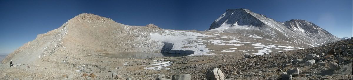
Apr 9, 2006 at 1:07 pm #1354480Cary,
That is a good decision to acclimate at Onion Valley the night before. It is one of the reasons I prefer Kearsarge over Shepherd. I thought I would post a pic from my trip through Shepherd Pass in October to help motivate your buddy.
 Apr 9, 2006 at 5:30 pm #1354504AnonymousInactive
Hi Cary,
One last thought: It can get pretty hot going up to Anvil Camp once you’re into the Shepherd Creek drainage, and heat can complicate staying hydrated which, in turn, can increase susceptibility to altitude sickness. With this in mind, you might consider getting a real early start, using headlamps, and try to get close to Anvil Camp before the sun starts to really heat things up(around noon or so). Beyond Anvil Camp heat isn’t nearly as much of a problem, due to the elevation and a good chance there’ll be an afternoon breeze coming off the Pass. Hope you have a great trip!Apr 9, 2006 at 8:03 pm #1354520Thanks for everyone’s input – all was taken into the math equation to determine best trip.
Yes – I remember the heat mid-day at Mahogany flat a few years back with my 50pound pack.
If I can get up early (will be tired after working a race sunday am & then driving down afterwards), plan is definitely to start early.
Biggest factors for going this way wound up being – 1)same entry/exit so no shuttle hassle to worry with 2)fastest way into upper kern so more time spent chasing big golden trout & exploring the area 3)no bear canister required.
Still not thrilled about that climb, but once over the top it’s all heaven. Love that upper Tyndall Creek with the view across to Milestone & other peaks. Also HATE the snow crossing at the top of the pass, but will certainly be nicer with an ultralite pack.
Apr 9, 2006 at 8:04 pm #1354521that shot makes Tyndall look like an easy walk-up!
Apr 10, 2006 at 5:33 pm #1354591AnonymousInactiveHi Cary,
If you do run into icy snow coming off that last switchback just before the pass, you should be able to scramble up the scree above the trail and top out just north of the normal route. Chances are you’ll see footprints where others have done it. It definitely isn’t worth chancing if you don’t have crampons, as it’s a long, rough ride down the chute if you lose it.Apr 24, 2006 at 8:03 pm #1355423I climbed kearsarge via onion and on to Forester then out the Whitne portal in 1970. It was a wonderful hike and I plan to repeat it in the next 10 years. its all good.
Dec 15, 2006 at 2:18 pm #1371169AnonymousInactiveThe best, most scenic part of the hike, in my opinion, up to Forrester thru Vidette Meadow begins at the intersection with the side trail to Center Basin. It is really a beautiful hike. I would like to avoid the descent down into Vidette and back up thru all of that lost elevation. Has anyone come over into Center Basin from Kearsarge Lakes via University shoulder? Is this a reasonable alternative to going around thru Vidette Meadow? Standing at lake level, it looks like an easy hike from the lakes up to the shoulder of University Peak but the south side of the shoulder looks somewhat dubious on the map. Secor mentions this route as a ski route. Does anyone have any experience with this as a hike?? Thanks for your anticipated replies, John
-
AuthorPosts
- You must be logged in to reply to this topic.
Forum Posting
A Membership is required to post in the forums. Login or become a member to post in the member forums!
Our Community Posts are Moderated
Backpacking Light community posts are moderated and here to foster helpful and positive discussions about lightweight backpacking. Please be mindful of our values and boundaries and review our Community Guidelines prior to posting.
Get the Newsletter
Gear Research & Discovery Tools
- Browse our curated Gear Shop
- See the latest Gear Deals and Sales
- Our Recommendations
- Search for Gear on Sale with the Gear Finder
- Used Gear Swap
- Member Gear Reviews and BPL Gear Review Articles
- Browse by Gear Type or Brand.
