Topic
Foothills Trail Notes – April
Forum Posting
A Membership is required to post in the forums. Login or become a member to post in the member forums!
Home › Forums › Campfire › Member Trip Reports › Foothills Trail Notes – April
- This topic is empty.
-
AuthorPosts
-
May 18, 2009 at 7:36 pm #1236402
As Adam McKinney drove away from the trail head atop Sassafras Mountain on South Carolina's Foothill Trail, I was tempted to run after him and beg off.
There is always a bit of trepidation before launch and this time it was heightened by uncertainty caused by arthritis in my cervical spine. The question of wisdom loomed large even after weeks of physical therapy and fairly disciplined exercise to relieve symptoms in my neck and arms. However, Adam did drive off and the die was cast and off I went with the usual blend of excitement and niggling worries.
The Foothills Trail runs along the Blue Ridge escarpment on the border of North Carolina, South Carolina and Georgia. It's been described as the "most unsung, under-used, and under-rated long trail in the Southeast." What could be better? As a Maine Yankee ready for a break from a long and snowy winter, April in the southern mountains sounded pretty good!
Putting the trip together was fairly easy using the information on the Foothills Trail Conference website. I contacted Adam through info on their shuttle page and he turned out to be a fantastic chauffeur and guide to fine diners on the back roads between Oconee State Park and the trip's start. On his recommendation, I began from the summit of Sassafras rather than Table Rock State Park. While it felt like a bit of a cheat, I'm always open to advice from those who've gone before.
The trail map published by the FHTC is widely available and is well done. The inserts are helpful around sometimes confusing trail heads and would have saved me a mile or two if I'd had the smarts to use them more carefully. I did not find the guidebook especially helpful but gleaned a few nuggets from it; if you like detailed trail descriptions you'll likely enjoy it. Long Trails of the Southeast by Johnny Molloy provides a well written and sufficiently detailed overview.
The trail is 76 miles long. An optional spur to Caesar Head State Park adds 10 miles. It can easily be linked to the southern terminus of the Bartram Trail on the Chattooga River, and hence to the Appalachian Trail at Wayah Bald near Franklin, NC.
Compared to the rock garden trails of New England, the walking is smooth and easy and gradients are on average relatively gentle. I was able to hike about 75 miles including side trips in 7 easy-going days with lots of stops for photography, late starts, and dawdling.
It is well-maintained, with fully engineered bridges, stairs steps on many steep slopes, etc. While some have noted that the stair treads make it difficult to find a natural stride, where they have blown out in a couple of spots, the trail is a mud-slide – my sense is that they contribute greatly to erosion control.
Day 1 – Sassafras Mountain to Eastatoe Gorge

First steps were at noon. My journal comments on those nagging concerns, and then gets to the point. The woods were quiet except for spring birds. A grouse broke from cover with characteristic booming wing beats. The temperature rose and fell as clouds passed under the sun. Budding leaves and tree flowers colored the hills with vivid green, crimson and orange. Dogwoods shone like white lanterns through the woods. Ephemeral spring flowers were in full bloom and profuse in number and variety. All was well with the world, in spite of any worry stones I chose to carry in my rucksack.Starting from the summit of Sassafras opened time to walk into the Eastatoe Natural Heritage area, a worthwhile 5 1/2 mile side trip. While I don't know ferns from shinola, the fact that Eastatoe Gorge is home to several rare ones added a little extra spice to the walk. The glory and diversity of the southern Appalachian hardwood forest really began to sink in as the afternoon wore on; there are more tree species per mile than you can shake a New England stick it. And a grand-daddy Maine Sugar Maple looks like a young pup tulip poplar.
Nuts and bolts:
> There is a campsite just below the Chimneytop Gap road crossing that is nicely placed for those who start at Table Rock. Look for the big boulder below the trail. However, there was just a trickle of water in a nearby seep even after heavy rain the day before.
> Camp in the Eastatoe Gorge was upstream of the trail junction; there are several possible fairly lightly used campsites along with more heavily impacted sites right on the stream.
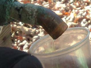
> Water was readily available from small streams and seeps. There was a very heavy rain the day before. My guess is that there are times when this is a fairly dry section.Day 2

After a chilly night with a 3/4 moon shining through my tarp, I rolled out at 7:30. Thing is, it was still dark dark at 6:45 and pretty darned dark at 7:00, so add a little procrastination and that seemed like a humane and civilized time to crawl out of the mummy's womb. After firing up the wood stove (bush buddy) and sitting back with a nice tall cuppa, I remembered that it's Easter Sunday and a glorious one at that. Not a cloud in the sky, crisp dry air…life is good. I gave thanks.The morning pace was more ambling that purposeful and I stopped often to photograph and ponder. It was after 11 when I finally got back to the FHT itself and began the traverse along Flatrock Mountain.
The trail climbs fairly steadily but with very few sections that I'd call steep – and these all have stairs built in courtesy of Duke Energy who donated the land I'm walking on.
Though the trail does not go over the summit, there were lovely views through the woods. While it was difficult to get good photos of the landscape because of the gauze of limbs and spring leaves veiling it, it was never the less spectacular. I'm not sure that I would do it any time but the spring. The combination of color and the open forest canopy before leaves close in the green tunnel is beguiling. I lunched at a stream crossing for 45 minutes of soaking feet in water, face in sun rays and socks and boots in drying air.
Eventually, the trail dropped into the Laurel Fork watershed and followed this lovely stream for 3 or 4 miles to the evening campsite at Laurel Fork Falls. Along the way it threaded through more spectacular woods of pine, poplar and hemlock. It passes a smashed still that doesn't appear all that old. If you're interested in the distilling aspect of southern Appalachia, check out the book Our Southern Highlanders by Horace Kephart.
I arrived at the falls by 4 and spent the afternoon setting up camp. I split wood (Mora knife) in anticipation of overnight rain as high clouds rode under sun and started to lower. Dinner was a leisurely pot of chicken stew. Well-being is a snug tarp, warm sleeping bag and dry wood. The worries about neck and spine, while far from groundless, evaporated in the doing of the day.
Day 3

A steady rain started at about 1:00 AM. I have the habit of waking up and checking that nothing has drifted out from under the tarp – an instinct honed by years of using down sleeping bags. Everything was a-okay, so back to sleep I went. When I did wake up for the day, it was solid gray and solid drip. In keeping with the relaxed pace of the trip, I read, wrote and dozed for a while before finally rousing and packing up the bulk of my gear.I cooked breakfast under the tarp with the Bushbuddy stove. I know folks have used one in a tent vestibule, but it smokes if you overload it with fuel, which I seem to have the habit of doing.
The relaxed start paid off in that by time breakfast was done, the rain stopped. While the day remained heavily overcast and moist, no more rain until I was settled into the evening camp.
The day's walk was largely along old logging roads that contour across the terrain at grades that are gentle by necessity of function. Imagine controlling the decsent of several tons of logs… The large and awe-inspiring trees along Laurel Fork were replaced with younger, scragglier ridge-top woods of chestnut oak and pine. While evidence of the hand of man is never absent, the trail covers remote terrain that is lightly traveled.
Navigation in this section would be difficult if not for the blazes. The trail is built on a confusing skein of logging roads. The map is somewhere in the neighborhood of 1:64000 and while excellent doesn't provide enough detail to unravel the tangle. Fortunately the FH Trail Conference has done an EXCELLENT job of marking and maintaining the route.
I stopped briefly at Rock Creek for photography and then on to the Toxaway River. In the 1/2 mile or so before the bridge, the white blazes have been chipped into a collection of ghouls' faces in an array of moods from foul to friendly. Someone had a lot of fun creating the gallery – pretty cool!
Lunch on the bridge in spite of a chilly breeze; it's always nice to be in the open for a few minutes after hours and days in the woods. The weather continued to threaten and with 5 miles to go I became more focused on making distance. Aside from a couple of stops for photography and taping my feet, the remaining daylight was devoted to focused walking.
My destination for the evening was the campsite at Bear Gap, but the first drops of rain coincided too well with arrival at a lightly used but established site on Cobb Creek. At least I think that it was Cobb Creek. I have to admit that as the trail snaked in and out of drainages and my mind wandered along, I did not keep particularly careful track of where I was.
The tarp was up and wood collected before real rain began to really fall. At some point during the set up, I sat on my glasses. A little bend here, some duct tape there and I was ready for the back country fashion show.
Day 4

It rained on and off most of the night and got serious at about 6:00 AM. Determined to wait it it out if at all possible where I was dry and cozy, I continued my career as a backcountry man of leisure. At 8 there was some lightening and maybe a glimpse of blue, but years of experience convinced me that it was nothing more than a sucker hole and I continued to lounge. Cook up a little coffee, read a little, write a little, snooze a little, day dream and think about moving. For most of the morning, the pattern continued to be rain punctuated by downpours.Finally at 11, I packed up and headed on my way. At 12 I put the tarp back up for lunch and another round of waiting it out. It was strenuous. This is the first time that I've ever been so determined to stay more or less dry. In part it was an effort ease the physical impact of carrying a pack by breaking my usual pattern of up and out early, hike all day and stop at dusk. Miraculously it paid off – the rain stopped for good as I packed up lunch. While it showered occasionally and leaf drip was constant, I walked along talking to the weather and explaining how nice it would be to have a nice sunny, dry afternoon. And so it came to pass. As always, the rain intensified color and my appreciation of the changing light as things lifted slowly.
Once I got going, there was no more time for dawdling. I didn't really start hiking in earnest until about 1 and had about 12 or 13 miles to cover. There where some real highlights however. The section along Bearcamp Creek included a white pine stand that could have been right out of northern Minnesota if not for the mountain holly, rhodadendron and magnolias that were scattered throughout.
This sense of having stepped back into the north country recurred time and again over the course of the trip. It was evoked in the dense shade of hemlock, but most compelling in those stands of white pine with the red-flecked carpet of partridge berry. Really lovely. For more about the twining ecology of north and south along the Appalachian spine, read Mountains of the Heart (Scott Weidensaul).
From Thompson River to the campsite near the Whitewater River took about an hour. I slowed my pace again, stopping to listen to the birds and reflect that even on a backpacking trip that's devoted to becoming immersed in nature, I rarely stop all activity and still all thought and just listen and observe. It is an act of deliberate focused attention.
I arrived at the campsite as the shadows lengthed to find it filled to overflowing with one group of kids from Brevard College and another group of youth at risk whose leaders were not exactly encouraging about me shouldering in – though in fairness not rude about it either. So much for solitude.
I did manage to find a flat patch of ground and enjoy a crystal clear evening with a nice strong, day wind that indicates the passage of a front and predicted dry weather for at least the immediate future.
Day 5

The wind blew most of the night hard enough to rattle tree bones; one of the trip leaders mentioned being awake all night worrying about falling trees and branches. Not me… I must have developed a hard crust of complacency somewhere along the way.Morning dawned crystal clear and cold enough to pull my wool cap as far down over my ears as it would go. Up and at 'em early enough to enjoy the crisp air and a stroll beside the tumbling and well named Whitewater River. While Whitewater Falls may be the highest east of the Mississippi and is certainly impressive, it was the walk along the river below the falls that I most enjoyed. More soaring pines and a couple of White-tailed deer thrown in for spice. One of those "don't move – let's see how long you can hold a deer's curiosity" kind of moments that always seem longer than they really are.
I got to the overlook to the falls in time for lunch. It's one of those beautifully constructed Forest Service jobs built to attend to car-driving tourists. No one was there when I arrived and I spread out to enjoy food and drink, dry damp socks, and so on. Shortly after that, the first clean, polite and well-coiffed family arrived and I was transformed from a self-reliant outdoors guy with great self-esteem to a complete dirtbag in the second that the auld fella spent looking me up and down. And so it goes.
The walk up Grassy Knob passed in a post-lunch, strong sun daze that was highlighted by a spring gushing cold and needed, and several park benches (I swear it on a stack of Bibles) perfectly placed for lounging and taking in the expansive views over Lake Jocasse. From the summit, it was a long, fast and pleasant walk to SC 107.
I arrived at the road crossing at 4:30 and continued, with the intent of stopping at the first campsite that sruck my fancy. The tightly squiggling topo lines did not bode well but I placed my trust in providence. Providence came through three hours and 7 1/2 miles later on the banks of the Chattooga at Burrells Ford. Fast, focused set-up and pot cleaning in the light of dusk and then to bed.
A logistical note on this section – camping sites with water are scarce as hen's teeth. There is one at Round Mountain Gap. Other dry sites are scattered between the gap and SC 107 with just a few springs and seeps between for water. Between 107 and the summit of Medlin Mountain, I did not see a flat patch of ground, but I suppose one is there somewhere. There are dry sites on Medlin; the nearest water is just before the Fish Hatchery road crossing. It's approximately 15 miles from the Whitewater River to Burrells Ford on the Chattooga.
Day 6

Another day of sunny leisure mosying along the Chattooga from Burrells Ford to camp on the flats upstreem from the Rock Gorge. I don't think that I covered 5 miles, but there was plenty of time for photography, a side trip to King Creek Falls, long lunches and lounging on bedrock ledges.My journal for the day is sparse, noting only that I flushed a turkey on the flank of Round Top and stopped at Big Bend Falls. I remember reflecting on the differences between traveling along a river and riding on its back. Paddling was a first and abiding love and I thought longingly of the thrill of capturing the energy of flow on a couple-hundred square inches of paddle blade and soaring.
The flats where I camped is the last site on the Chattooga, but the next morning revealed a scattering of nice, little used options along Pigpen Branch another mile or so farther on.
Day 7

Through-out the trip I'd held low expectations for the last day's walk to Oconee State Park. I had no good reason for this and don't know where or how I copped the attitude. It proved miserably inaccurate, as prejudice so aften is.Spring had advanced over the week and 2000 foot elevation loss from the start on Sassafras. Leaves were still tender but furled less tightly. If the rushing water was the center of attention yesterday, the forest recaptured the stage today.
The first highlight came at the crest of Dodge Mountain in a stand of Tulip Poplar. This tree more than any other captured my fancy. Even the latin name Liriodendron tulipifera has a certain liquid quality about it. The tallest hardwood in North America, it reaches 150 feet and 7 feet in diameter at "breast height," which is to say above the butt swell. Big trees. It's in the Magnolia family, which causes cognitive dissonance when compared to the understory branch of the family. Its name captures two of the lovely aspects of the tree – the yellow and orange blossoms do resemple tulips, and the luminous spring green leaves flutter in the slightest breeze very much like Quaking Aspen, or "popple".
The trail also passed through several dry and sunny stands of pine and oak with a solid carpet of blueberry. Oak-pine forests are fairly common on dry, exposed sites on the edge of the Southern Blue Ridge escarpment.
Which is precisely what the trail does along the east facing slopes of Dodge and Long Mountains, where there are expansive views (throught the trees) out toward the Piedmont. You're walking along the crest of the southeast face of the Appalachians – literally at a defining edge of a rope of mountains that stretches to Newfoundland over 2000 mile to the northest. It's very cool!
I dipped back into cool hemlock woods along Tamasee Creek, where there are occasional campsites. From the Clear Branch watershed, the trail climbs briefly back over the shoulder of Long Mountain, where the view expands to fill the horizon for one last time before the trail enters Oconee State Park. By mid-afternoon, I was back at the car, hot, tired and thirsty, but very pleased with the rewards of the past week. The Foothills Trail is truely a great hike! Time to celebrate with cold beer and hot burritos!
May 19, 2009 at 4:53 am #1502094Great report, it is one of the trails we have talked about for sometime but have not gotten to. Need to put it on the list for this winter.
May 19, 2009 at 7:12 am #1502111Jack,
Thank you for an extremely well written chronicle of your journey. It picks up the reader and places them in your shoes. The photos were also very professional.
May 19, 2009 at 10:53 am #1502175Thanks so much for taking the time to post that report. Are you a professional photographer- if not you should consider it as your pics are amazing. Admitting that there's no way I'd get as good of pics even if I had the same equipment I'm curious what photographic equipment you use? Thanks again for a great report!
May 19, 2009 at 1:36 pm #1502212Great trip report. I have hiked most of this trail in sections on weekends but hope to hike the entire trail this Summer. Did you choose the Sassafras to Oconnee route for any particular reason as opposed to starting at Oconee?
May 19, 2009 at 3:31 pm #1502222Nicely done! [applause]
Awesome hike and I can't wait to go back.
I did it in Oct '07 but started at Oconnee and ended at Table Rock (Adam shuttled me also, did ya'll eat at that little joint near Oconnee)?
I'd like to go in the winter when the leaves are off the trees to check the view. Also want to lengthen it by bypassing Table Rock (very spectacular place to end and strenuous climb if starting there) and continuing to Caesar's Head.My avatar pic is from that hike, at Table Rock.
May 19, 2009 at 4:08 pm #1502230I also got to examine that "still" up close.
I think it's just an old water heater that washed down that hill.
It's possible that it was used as a still, but it doesn't look
like any of the ones I have seen, and the pipe down the center doesn't make sense.
Just thought I'd mention it, because I had examined it when I went by it, after reading about it in the guide.
May 20, 2009 at 3:21 am #1502390Hey Chris – thanks for the insight on the still…having never seen one in action, I have no idea what makes sense. A little less "romantic" as a water heater, but still interesting.
Re the cafe between way to Table Rock – thats the one. Nice folks.
May 20, 2009 at 3:24 am #1502391Keith – I'm not even close to a professional photographer. I just took the time to work on it on the FHT.
Gear was a Panasonic FZ 28, a spare battery, a small tripod, a polarizing filter and a neutral density filter. Total wght about 3 pounds.
May 20, 2009 at 3:27 am #1502392Bill – I'm lazy and the trail looses elevation starting from Sassafras. Not enough to matter all that much I reckon :)
May 22, 2009 at 5:10 pm #1503064As nice as these photos are, you were pretty stingy with them. It'd be great to see the rest of the photos.
May 23, 2009 at 9:42 am #1503122Jack, I really enjoyed reading your trip report. Excellent writing and superb pics. I, too, would love to see some more pics. By the way, would you buy the Panasonic FZ 28 (or updated version) again? Thanks for posting your trip report. –Mike
May 25, 2009 at 3:27 am #1503329Thanks for the compliment Tom! Here's a link to the photo album on line.
http://picasaweb.google.com/jackoutside/FoothillsTrailApril10182009?feat=directlink
May 25, 2009 at 3:50 am #1503332Hey Mike
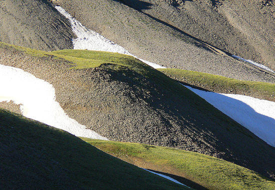
I would absolutely go for the FZ28 or something like it again. I enjoy the "superzoom" mostly because I really like pulling in landscape "textures" – this as an example from the Absarokas in Wyoming. This was shot across a ravine; there is no way that I could have taken this without a long telephoto.

The macrozoom on the FZ28 also worked well for flowers.
So I am pretty satisfied with it. The downside is that it weighs 13 oz. but it's worth the versatility for me.
May 25, 2009 at 4:40 am #1503336Jack, you have some great photos there. I especially like the fiddlehead and the Bellwort, but it's not limited to those.
May 26, 2009 at 12:58 pm #1503673I am just starting to get into photography and have to ask:
How did you do those shots of the flowers and keep an even black background?
Are they night shots or did you bring a black card to place behind them?
thanks
–scott
May 26, 2009 at 6:41 pm #1503758You can get really shallow depth of field shots by opening up your aperture all the way, say F 1.8, F 2, depending on your lens type and what your camera offers. Either do that manually or set it to a macro setting which essentially emulates the above. You get a lot of light fall off with a wide open shutter and you get those nice forefront focused images with blurry backgrounds. This is one method, a common one at least.
May 27, 2009 at 6:39 pm #1503984Scott – the nice thing about the camera that I used is the telemacro feature. The droopy yellow flower (bellwort) is about 1" long sitting on a stem 4 -5" tall. The shot was taken from about 3 1/2 feet away with the equivalent of about a 400mm lens. Most cameras can't focus that close at that focal length…so a big part of the success of that shot rests on gear.
As to technique, the trick is to find a blossom in the sunlight that can be shot against a shaded background and then underexpose. Because you want to use the fastest shutter speed possible to keep details crisp, use the widest aperture available. Again…the camera you use and how "zoomed out" you go dictates this.
Here's another example shot under high-noon conditions which are lousy for photography – the "deep shadow" is just the shade from a tree. This one's a bit overdone, but it makes the point. The exposure info is 1/000 of a second and f2.8a and "ISO" = 100… which tells a lot about how bright the lighting was.

Compare that to this – same place, same kind of flower, same kind of shade. This time though, the blossom was in the shade rather than in full sun. The numbers were 1/200 of a second at f3.4 and ISO 400…this is several orders of magnitude of more light being used to expose the shot. Someone who is a real photographer can probably figure out how many orders… but it's a big difference.
May 18, 2010 at 5:13 pm #1611021This just tickled my funny bone. Gillian Welsh has a tune called Acony Bell (http://mog.com/music/Gillian_Welch/Revival/Acony_Bell) which I am fairly sure is a reference to Oconee Bells, (http://plants.usda.gov/java/profile?symbol=SHGA) which grows along the trail.
Hee Hee. A pointless post but like I said my funny bone is tickled and its better than working.
Jun 11, 2013 at 2:37 pm #1995678….this article as it was linked from a forum on Whiteblaze.net.
One of the best trip reports I've had the pleasure of reading on this site.
I'm planning on doing this trail soon.
Great photos!Jun 12, 2013 at 10:28 pm #1996123Great report, and your photos are excellent. I used to bring my SLR but 3lbs make it nearly impossible to keep my base weight below 10lbs. I especially like your time exposures. keep up the good work.
Cheers!
jt
-
AuthorPosts


- You must be logged in to reply to this topic.
Forum Posting
A Membership is required to post in the forums. Login or become a member to post in the member forums!
Our Community Posts are Moderated
Backpacking Light community posts are moderated and here to foster helpful and positive discussions about lightweight backpacking. Please be mindful of our values and boundaries and review our Community Guidelines prior to posting.
Get the Newsletter
Gear Research & Discovery Tools
- Browse our curated Gear Shop
- See the latest Gear Deals and Sales
- Our Recommendations
- Search for Gear on Sale with the Gear Finder
- Used Gear Swap
- Member Gear Reviews and BPL Gear Review Articles
- Browse by Gear Type or Brand.
